Give us feedback!


 See all

Our philosophy is simple. We want to encourage you to dream. BIG! Then we help you plan your trip, get the most out of it while you're traveling and help you share your experience with friends.
Join Now It's FREE
Dream Packages
Duration: 4 days
Price: $1026.70
Price: $1026.70
Duration: 10 hours
Price: $224.21
Price: $224.21
Duration: 6 days
Price: $606.00
Price: $606.00
Duration: 10 hours
Price: $199.57
Price: $199.57
Related Categories
- Australian National Parks & Reserves
- Canadian National Parks
- Canyoneering
- Day Hikes
- Guided Hikes
- In the Mountains
- Mountaineering
- Mountains
- New Zealand Great Walks
- New Zealand National Parks
- Parks & Reserves
- Rock Climbing
- South African National Parks
- UK National Parks
- UNESCO Parks & Preserves
- US Historical Parks (NHP)
Dreams Still To Do
Checked-Off Dreams
Dreams Still To Do
Checked-Off Dreams
Advertisement
Explore Hikes & Treks
-
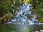
Hike to Chemerong, Berembun & Langsir Waterfalls, Terengganu. Malaysia
One of Malaysia’s highest waterfalls are located in a remote district of Dungun, Terengganu, Malaysia. The waterfalls are: Chemerong Waterfall 1214 feet (370 meter): This waterfall takes a 1-2 hours of jungle hiking depending on experience. At the waterfall hikers can continue to follow trail to a nearby mountain, Mt. Berembun and Langsir and Berembu waterfall... -
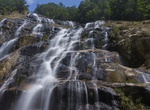
Hike to Chenuis Falls, Mount Rainier National Park
Chenuis Falls is a secluded waterfall in the northwest corner of Mt. Rainier National Park, accessible only on foot by crossing the glacier-fed Carbon River. -
Hike Cherry Canyon Trail, Santa Rosa Island, California
A loop hike with riparian vegetation and views of Bechers Bay. Other trails branch off of the Cherry Canyon trail allowing for visits to Black Mountain, the campground, and Water Canyon beach. -
Hike or Bike Cherry Cover Overlook, Santa Catalina Island, California
This is a nice easy hike from Two Harbors along the flat road to the West End. About 2.25 miles round trip. -
Hike Cherry Valley, Santa Catalina Island, California
Cherry Valley is named for the native cherry trees, Prunus ilicfolia, which grow there. The seat of an early mining, where the hillsides are honeycombed with tunnels. From 1862 to 1964 the Island was swarming with prospectors for precious metals. The seat of the excitement seems to have been at Cherry Valley. Every foot of ground from the sea to the summit of the hil... -
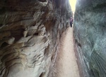
Hike Chesler Park Loop/Joint Trail, Canyonlands National Park, Utah
The Chesler Park Loop/Joint trail is 11 mi (18 km) round-trip trail in the Needles District of Canyonlands National Park. It's a moderate hike, very scenic and provides a multitude of route options to choose from. There are a lot of interesting rock formations along the hike. Three miles along this trail brings visitors to a saddle overlooking Chesler Park, a scenic ... -
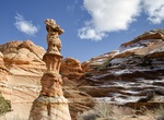
Hike to Chess Queen (The Totem Pole), South Coyote Buttes, Arizona
The Chess Queen (The Totem Pole), is located a few hundred yards east of Cottonwood Cove, in Vermilion Cliffs National Monument, Arizona. It is just outside the boundary of Coyote Buttes South, which requires a hiking permit from the BLM. -
Hike or Bike Chicago Lakefront Trail, Chicago, Illinois
The Chicago Lakefront Trail (abbreviated as LFT) is a foreshoreway for walking and cycling, running 18-mile (29 km) along the coast of Lake Michigan in Chicago, Illinois. The path connects various beaches and recreational amenities located along the lakefront and also serves as a route for bicycle commuters. The trail is located wholly within the Chicago city limits a... -
Stroll Chicago Riverwalk, Chicago, Illinois
The Chicago Riverwalk is an open, pedestrian waterfront located on the south bank of the Chicago River in downtown Chicago, Illinois. It spans from Lake Shore Drive to Franklin Street. Called the city's 'Second Lakefront', the Riverwalk contains restaurants, seating, boat rentals, and other activities. It is currently being expanded to 9 blocks and is scheduled for co... -
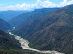
Explore Chicamocha Canyon, Chicamocha National Park, Santander, Colombia
The Chicamocha Canyon (Cañón del Chicamocha) is a steep sided canyon carved by the Chicamocha River in Colombia. With a maximum depth of 2,000 metres (6,600 ft), an area of 108,000 hectares (270,000 acres) and a length of 227 kilometres (141 mi), the canyon is the second-largest worldwide. The canyon is situated in the departments of Boyac&aacu... -
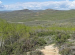
Hike Chicken Creek Nature Trail Loop, Fossil Butte National Monument, Wyoming
This trail is easy to moderate. There is some shade on this trail while the aspen trees have leaves on them. Pack sunscreen bug spray, a hat, and plenty of water.This trail winds through sagebrush and a spring-fed aspen forest. Wildflowers are plentiful in spring and many animals including birds, marmots, elk, pronghorn, and occasionally moose can be seen along the tr... -
Hike or Ride Chief Ladiga Trail, Alabama
The Chief Ladiga Trail is a rail trail in Alabama. It is the state's first rail trail project. The 33-mile (53 km) trail stretches from the Alabama-Georgia state line to Weaver. The Chief Ladiga is on the same rail corridor as the Silver Comet Trail in Georgia as far as Piedmont, Alabama. From there it parallels an abandoned Southern Railway line for a few miles west ... -
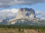
Summit Chief Mountain, Glacier National Park, Montana
Chief Mountain (also called Old Chief Mountain) is located in the U.S. state of Montana on the eastern border of Glacier National Park and the Blackfeet Indian Reservation. The mountain is one of the most prominent peaks and rock formations along the Rocky Mountain Front, a 200 mi (320 km) long overthrust fault, known as the Lewis Overthrust, which extends from centra... -
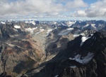
Trek Chigmit Mountains, Alaska
The Chigmit Mountains are a subrange of the Aleutian Range in the Kenai Peninsula and Lake and Peninsula Boroughs of the U.S. state of Alaska. They are located at the northeastern end of the Aleutian range, on the west side of Cook Inlet, roughly 120 miles (200 km) southwest of Anchorage. The closest major towns to the range are Kenai and Homer, across Cook Inlet on t... -
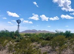
Hike Chihuahuan Desert Nature Trail, Big Bend National Park, Texas
Both natural and cultural history are evident at Dugout Wells. On this easy desert stroll you will see remnants of human settlement and typical Chihuahuan Desert habitat. A shady oasis with cottonwood trees and tables at Dugout Wells provides a good area for picnicking and bird watching. Begin at Dugout Wells, 6 miles southeast of Panther Junction.


Price: $779.00