Give us feedback!


 See all

Our philosophy is simple. We want to encourage you to dream. BIG! Then we help you plan your trip, get the most out of it while you're traveling and help you share your experience with friends.
Join Now It's FREE
Dream Packages
Duration: 14 hours
Price: $341.00
Price: $341.00
Duration: 2 days
Price: $469.00
Price: $469.00
Duration: 6 days
Price: $606.00
Price: $606.00
Duration: 30 minutes
Price: $263.77
Price: $263.77
Related Categories
- Australian National Parks & Reserves
- Canadian National Parks
- Canyoneering
- Day Hikes
- Guided Hikes
- In the Mountains
- Mountaineering
- Mountains
- New Zealand Great Walks
- New Zealand National Parks
- Parks & Reserves
- Rock Climbing
- South African National Parks
- UK National Parks
- UNESCO Parks & Preserves
- US Historical Parks (NHP)
Dreams Still To Do
Checked-Off Dreams
Dreams Still To Do
Checked-Off Dreams
Advertisement
Explore Hikes & Treks
-
Walk on Clark Dry Lake, Anza-Borrego Desert State Park, California
Located off of Rockhouse Trail road is Clark Dry Lake. No driving on it. So just get out and hike for some great photos. It is surrounded by 3000-6000 foot high mountains (Coyote Mountain to the west with Rabbit & Villager Peaks to the east). Naval Outlying Field Clark's Dry Lake was a United States Navy facility built for World War II. The site had two runways an... -
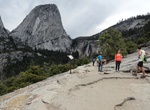
Hike to Clark Point, Yosemite National Park, California
Take the John Muir Trail from Happy Isles Trailhead to Clark Point, which offers a great alternative hike to Nevada and Vernal Falls. -
Hike Clark's Creek Trail, Grays Harbor County, Washington
Clark's Creek Trail is a 2.2 mile heavily trafficked loop trail located near Puyallup, Washington that features a river and is good for all skill levels. The trail offers a number of activity options and is accessible year-round. Dogs are also able to use this trail. -
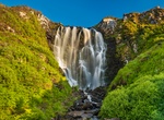
Hike to Clashnessie Falls, Sutherland, Scotland
Clashnessie Falls is 15m high and located in the hamlet of Clashnessie near Stoer in Sutherland, Scotland. -
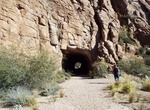
Hike to Claypool Tunnel, Superior, Arizona
The abandonedClaypool Tunnel,located near Superior, Arizona, was built in 1922 for US Route 60.crucial link in theMiami-Superior Highway,replacing the Apache Trail as the primary route between Phoenix and Globe.It was later replaced by theQueen Creek Tunnel,completed in 1952 The area around the tunnel also offers scenic views and opportunities for exploring the surro... -
Hike Clear Creek Trail, Grand Canyon National Park, Arizona
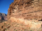
The Clear Creek Trail is a 8.4 mi (13.5 km) hiking trail on the North Rim of the Grand Canyon National Park, located in the U.S. state of Arizona. The trail begins near the Colorado River at the bottom of the Grand Canyon, about 0.5 miles (0.8 km) north of Phantom Ranch at a junction with the North Kaibab Trail. From the junction with the North Kaibab Trail, the ... -
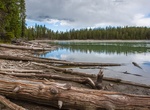
Hike Clear Lake Trail, Yellowstone National Park, Wyoming
From Uncle Tom’s Point parking area, this trail takes you through large rolling meadows and forested areas to Clear Lake (2.25 mi/3.6 km), a hydrothermal area. -
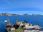
Hike Cleetwood Cove Trail, Crater Lake National Park, Oregon
Hike down Cleetwood Cove Trail from Rim Drive to this cove with dock for boat tours. The only legal access to the shore of Crater Lake, this is a strenuous and steep switchback trail with a steep grade (11%). -
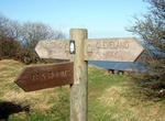
Hike Cleveland Way, North Yorkshire, England
The Cleveland Way is a National Trail in the historic area of Cleveland in North Yorkshire, northern England. It runs 110 miles (177 km) between Helmsley and the Brigg at Filey, skirting the North York Moors National Park. Development of the Cleveland Way began in the 1930s when the Teesside Ramblers' Association pressed for the creation of a long-distance path in the... -
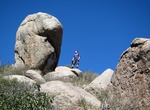
Hike Clevenger Canyon North Trail, Ramona, California
Clevenger Canyon North Trail goes threw boulder fields with some rocks standing on its end. This hike is about 5 miles east of the Wild Animal Park directly off the 78 Hwy. You start off heading down to a creek and then up up up to great views of the surrounding mountains and orange groves. -
Hike Clevenger Canyon South West Trail, Ramona, California
Clevenger Canyon South West Trail is a 4 mile out and back trail located near Ramona, California. -
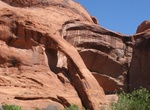
See Cliff Arch, Coyote Gulch, Utah
Near the end of the Coyote Gulch hike is Cliff Arch, a jug-handle style arch in the north wall of the canyon. It is only reachable by hiking Coyote Gulch. It is located within both the Grand Staircase-Escalante National Monument (upper sections) and the Glen Canyon National Recreation Area (lower sections). -
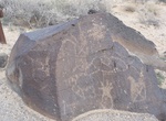
Hike Cliff Base Trail, Petroglyph National Monument, New Mexico
Cliff Base Trail is located in the Boca Negra Canyon section of Petroglyph National Monument. The Cliff BaseTrail has a restroom at its trailhead as well as an interpretive shelter which provides information about Boca Negra Canyon. Located off of Unser Boulevard, ¼ mile north of Montaño Road, this canyon provides quick and easy access to three self-gui... -
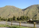
Summit Cliff Mountain, New York
Cliff Mountain is a mountain located in Essex County, New York. The mountain is part of the Marcy Group of the Great Range of the Adirondack Mountains. Cliff is flanked to the southeast by Mount Redfield. Cliff Mountain stands within the watershed of the Opalescent River, a tributary of the Hudson River, which in turn drains into New York Bay. The north and west sides... -
Hike Cliff Shelf Nature Trail, Badlands National Park, South Dakota
This loop trail follows boardwalks and climbs stairs through a juniperforest perched along the Badlands Wall. A small pond occasionally exists in the area and draws wildlife, such as deer or bighorn sheep. Climbs approximately 200 feet in elevation. Please stay on the trail.

Price: $371.99