Give us feedback!


 See all

Our philosophy is simple. We want to encourage you to dream. BIG! Then we help you plan your trip, get the most out of it while you're traveling and help you share your experience with friends.
Join Now It's FREE
Dream Packages
Duration: 2 days
Price: $398.24
Price: $398.24
Duration: 12 hours
Price: $224.21
Price: $224.21
Duration: 4 hours
Price: $129.99
Price: $129.99
Duration: 4 days
Price: $1457.59
Price: $1457.59
Related Categories
- Australian National Parks & Reserves
- Canadian National Parks
- Canyoneering
- Day Hikes
- Guided Hikes
- In the Mountains
- Mountaineering
- Mountains
- New Zealand Great Walks
- New Zealand National Parks
- Parks & Reserves
- Rock Climbing
- South African National Parks
- UK National Parks
- UNESCO Parks & Preserves
- US Historical Parks (NHP)
Dreams Still To Do
Checked-Off Dreams
Dreams Still To Do
Checked-Off Dreams
Advertisement
Explore Hikes & Treks
-
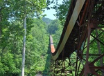
Hike Conveyor Trail, Nuttallburg, West Virginia
This steep, rugged trail zig-zags from the mid-bench level, not far from the mine entrance, to the old Keeneys Creek railroad line (trail). Views of the conveyor and gorge is visible from time to time, but be sure to watch your footing, for the trail surface is loose and slaggy (old coal debris from the conveyor) in many places. Evidence of this mine's operation is vi... -
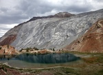
Hike Convict Canyon Trail to Mildred Lake, California
Convict Creek Trail to Mildred Lake is a 9.1 mile out and back trail located near Mammoth Lakes, California. It features a great forest and is best used from June until September. One of the nicest places to go in the eastern sierra (if you're into rocks) is Convict canyon. it's an easy drive to get there, and there's a pretty and not very long trail that goes up the... -
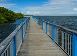
Hike Convoy Point Trail, Biscayne National Park, Florida
The canoe/kayak launch and greenspace at Convoy Point. -
Hike Conway Summit, Mono County, California
Conway Summit is a mountain pass in Mono County, California. It is traversed by U.S. Highway 395, which connects Bridgeport and the East Walker River on the north side of the pass to Mono Lake and Lee Vining to the south. It marks the highest point on U.S. 395, which also traverses high passes at Deadman Summit and Devil's Gate Pass. Conway Summit is named after John ... -
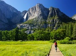
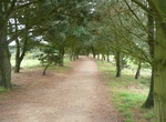
Hike Cook's Meadow Loop, Yosemite Village, California
Yosemite Valley Visitor Center (shuttle stop #5 or #9) Cook's Meadow is also accessible from shuttle stop #11 (near Sentinel Bridge) or shuttle stop #6 (Lower Yosemite Fall Trailhead) This short, easy walk offers stunning views of Yosemite Falls, Half Dome, Glacier Point, and Sentinel Rock. From the visitor center, walk west along the bicycle path toward Lower Yose... -
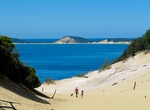
Hike Cooloola Great Walk, Great Sandy National Park, Queensland, Australia
The Cooloola Great Walk is a 102 kilometres (63 mi) coastal bushwalking route in the Great Sandy National Park of South East Queensland, Australia. Opened in 2010, it runs from Noosa North Shore to Rainbow Beach, and is planned as a five-day trek. The walk passes through rainforest, tall eucalypt forest, dry coastal woodland and heath plains. It is considered an easy ... -
Hike Coomera Circuit, Queensland, Australia
The Coomera Circuit, a 17.5-kilometre (10.9 mi) walking track (8 hours) within the Lamington National Park provides ideal viewing of the Coomera Falls and other smaller falls including Yarrabilgong Falls (150m) and the 160 m deep Coomera Gorge. The treck crosses the river six times. It was rated in 2010 by the Australian GeographicOutdoor magazine as the second best ... -
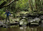
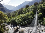
Hike Copland Track to Welcome Flat Hut, New Zealand
Hike the 18 km Copland Track up the Copland valley to Welcome Flat Hut, a popular overnight return trip for visitors to the Glacier Region. The track is located in Westland Tai Poutini National Park. Enjoy the natural hot pools at Welcome Flat. Access to Welcome Flat is possible year round, although snow and ice can cause difficulties in winter. -
Hike or Ride Corbiere Walk, Jersey (Channel Islands)
The Corbiere walk links St Aubin to La Corbiere on Jersey, and makes a very pleasant 4 mile linear walk. It follows an old railway line which closed in 1946. The path is very popular on the weekends, and has a mixture of families and cyclists. Half way along is the "On the tracks" Cafe. -
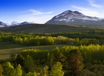
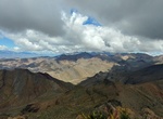
Summit Corkscrew Peak, Death Valley National Park, California
Corkscrew Peak is a peak in the Grapevine Mountains in Death Valley National Park. It is named for its shape, which loosely looks like a corkscrew. The trail starts from Daylight Pass Road. Its length is 5.8 kilometers. It follows a wash for about 3 kilometers, then a small canyon, and finally, a steep (25% average) ridge to the summit. -
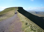
Hike Corn Du, Brecon Beacons National Park, Wales
Corn Du is a summit of the twin topped Pen y Fan and the second highest peak in South Wales at 873 m (2,864 ft), situated in the Brecon Beacons National Park. The summit itself is marked by a well structured Bronze Age cairn with a central burial cist like that on nearby Pen y Fan. The two summits are visible from great distances owing to their height above the surrou... -
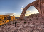
Hike to Corona & Bowtie Arch, Utah
Corona Arch is a natural sandstone arch near Moab, Utah in a side canyon of the Colorado River. Bowtie Arch is a pothole arch formed when a pothole broke through from the top of the cliff. They can be accessed via the Corona Arch Trail, a 1.5-mile (2.4 km) hiking trail from Utah State Route 279. -
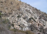
Hike Coronado Cave Trail, Coronado National Monument, Arizona
To get to the Coronado Cave trailhead drive toward the visitor center on East Montezuma Canyon Rd. Approximately .25 mile west of the visitor center on the north side of the road is the parking area for the trail. It is .5 mile to the cave entrance with an elevation gain of 500 feet. Some light scrambling over slick rocks is required to descend to the cave floor. This... -
Walk or Bike Coronado Ferry Loop, Coronado, California
This scenic loop connects the Coronado Ferry Landing, San Diego Convention Center, and Broadway Pier. Along the way, you’ll enjoy stunning waterfront views, lush parks, iconic landmarks, and plenty of restaurants, bars, and memorials. Start: Coronado Ferry Landing Explore the charming shops and restaurants with sweeping views of downtown San Diego. Grab coffee o... -
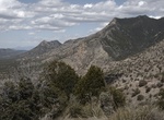
Hike Coronado Peak Trail, Arizona
This interpretive trail climbs from the trailhead at Montezuma Pass to Coronado Peak. The sweeping views of Sonora, Mexico and the San Pedro River and San Rafael Valleys can be enjoyed while resting on the benches under a shade ramada. Learn more about the journey of the Coronado Expedition, the native peoples that lived in this area, and about the flora and fauna of ...

Price: $469.00