Give us feedback!


 See all

Our philosophy is simple. We want to encourage you to dream. BIG! Then we help you plan your trip, get the most out of it while you're traveling and help you share your experience with friends.
Join Now It's FREE
Dream Packages
Duration: 12 hours 30 minutes
Price: $289.36
Price: $289.36
Duration: 4 days
Price: $1026.70
Price: $1026.70
Duration: 6 to 10 hours
Price: $86.83
Price: $86.83
Duration: 10 hours
Price: $224.21
Price: $224.21
Related Categories
- Australian National Parks & Reserves
- Canadian National Parks
- Canyoneering
- Day Hikes
- Guided Hikes
- In the Mountains
- Mountaineering
- Mountains
- New Zealand Great Walks
- New Zealand National Parks
- Parks & Reserves
- Rock Climbing
- South African National Parks
- UK National Parks
- UNESCO Parks & Preserves
- US Historical Parks (NHP)
Dreams Still To Do
Checked-Off Dreams
Dreams Still To Do
Checked-Off Dreams
Advertisement
Explore Hikes & Treks
-
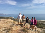
Ride Coronado to Cabrillo National Monument, Coronado, California
Begin your ride in Coronado at the Bayshore Parking Lot near the Coronado Yacht Club, and follow the scenic path along the golf course to the Ferry Landing. From there, take the Coronado Ferry across the bay to Broadway Pier, then continue riding along the San Diego Bay waterfront. Once you reach Point Loma, follow the road up to the top and out to the Cabrillo Nation... -
Summit Corona Mesa, East Cape, Baja, Mexico
Hike to the top of Corona Mesa on the East Cape, Baja, Mexico. This is a easy 2 mile hike to the top of a rock outcropping with some great views of the East Cape. -
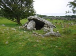
Hike to Cors y Gedol Neolithic Site, Snowdonia National Park, Wales
The monument consists of the remains of a chambered long cairn, dating to the early Neolithic (c. 4,200BC - 3,000BC). A long cairn is a roughly rectangular or trapezoidal mound of stone, usually between 25m and 120m long, with a length exceeding twice its greatest width. -
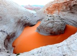
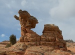
Hike to Cosmic Ashtray (Cosmic Navel), Utah
The Cosmic Navel, a.k.a. Cosmic Ashtray, Red Breaks Volcano, or Islomania Dome, is a rock form inside a bowl of sand atop a slick rock peak in southern Utah. To reach it, I traveled about 10 miles down Hole-in-the-rock Road near Escalante and turned left (east) onto Harris Wash Road. After about seven miles, this rough dirt road crosses Harris Wash. There is a sign s... -
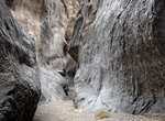
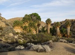
Hike Cottonwood Canyon Narrows, Utah
Cottonwood Canyon Narrows is a nice short hike through the final narrow gorge of Cottonwood Creek before the canyon opens up. Accessed off Road 400 (Cottonwood Canyon Road). -
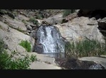
Hike to Cottonwood Falls, Pine Valley, California
Cottonwood Creek Trail is a 1.6 mile out and back trail located near Pine Valley, California. Cottonwood Creek is a major stream, about 36 miles (58 km) long, in southern San Diego County, California. It is part of the Tijuana River drainage basin. The creek begins in the Laguna Mountains, in the Cleveland National Forest near Pine Valley. It flows south through the C... -
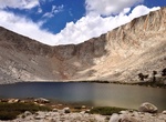
Hike Cottonwood Lakes Trail, Horseshoe Meadow, California
Located near Horseshoe Meadows, the Cottonwood Lakes Basin has many pristine alpine lakes and creeks located between Mount Langley and Cirque Peak. Side trails branch to Muir Lake, Hidden Lake, South Fork Lakes, Cirque Lake. Along the trail to New Army Pass are Long Lake and High Lake in the John Muir Wilderness. Climbing over New Army Pass the trail continues into Se... -
Hike Cottonwood Marble Loop (Marble Canyon), Death Valley National Park, California
Cottonwood-Marble Canyon Loop is a 26 to 28 miles (42-45km) loop route located in Death Valley National Park. It's only recommended for very experienced adventurers. From CA-190 Enter Stovepipe Wells Campground. Turn left on the Cottonwood Marble Road marked by a sign for the airport. Check conditions prior to travel. Cottonwood Marble Road: 10.5mi (17km). The fir... -
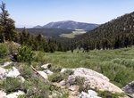
Hike Cottonwood Pass Trail to PCT, Horseshoe Meadow, California
Starting from the end of Horseshoe Meadows Road,the trail over Cottonwood Pass goes to the northern portion of the Golden Trout Wilderness. Small streams meander through tree-rimmed meadows in this wilderness area named for California's state fish, the Golden Trout. The Pacific Crest Trail junction at Cottonwood Pass gives the option to go to the southeastern portion ... -
Hike to Cottonwood Spring Oasis, Joshua Tree National Park, California
Cottonwood Spring Oasis is one of the best kept secrets in Joshua Tree National Park. It's located 7 miles from the southern entrance to the park. The spring, the result of earthquake activity, was used for centuries by the Cahuilla Indians, who left bedrock mortars and clay pots, or ollas, in the area. A short, easy walk down Cottonwood Wash leads past a second oasis... -
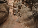
Hike Cottonwood Teepees Trail, South Coyote Buttes, Arizona
Cottonwood Teepees is located in the Coyote Buttes South area. Vivid earth-tone hues, swirling sandstone shapes and fragile rock layers are along the hike. You must have a permit to visit Coyote Buttes South. Permits are available for day use only. There is a daily limit on permits. In December, January, and February Coyote Buttes South online permits rarely sell out... -
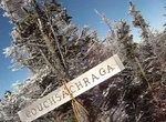
Summit Couchsachraga Peak, New York
Couchsachraga Peak is a mountain located in Essex County, New York. "Couchsachraga" is based on an Algonquin or Huron name for the area, meaning "dismal wilderness". The mountain is part of the Santanoni Mountains of the Adirondacks. Couchsachraga Peak is flanked to the east by Panther Peak. There is no marked trail to the summit, which, being fully forested, has no v... -
Explore Cougar Mountain Regional Wildland Park, Seattle, Washington
Cougar Mountain Regional Wildland Park is a regional park in King County, Washington, near the towns of Bellevue and Issaquah. The park was established in June 1983 to protect the central core of Cougar Mountain. With 38 miles (61 km) of hiking trails and 12 miles (19 km) of equestrian trails providing a true wilderness experience on Seattle's very doorstep, the ... -
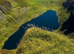
Hike to Coumshingaun Lough, Ireland
Coumshingaun is one of the most beautiful lakes in Ireland. -
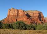
Hike or Mounatin Bike Courthouse Butte Loop Trail, Sedona, Arizona
The moderate 4.5 mile hike on Courthouse Butte Loop Trail provide great view of both Courthouse Butte and Red Rock. Courthouse Butteis a butte just north of the Village of Oak Creek, south of Sedona. Summit elevation is 5,440 feet (1,660 m). It is just east of Bell Rock. The eastern and northern sides are the most scenic, tranquil and upclose views of the trail. On t...

Price: $121.33