Give us feedback!


 See all

Our philosophy is simple. We want to encourage you to dream. BIG! Then we help you plan your trip, get the most out of it while you're traveling and help you share your experience with friends.
Join Now It's FREE
Dream Packages
Duration: 13 hours 30 minutes
Price: $572.77
Price: $572.77
Duration: 4 hours
Price: $129.99
Price: $129.99
Duration: 12 hours
Price: $224.21
Price: $224.21
Duration: 4 days
Price: $1457.59
Price: $1457.59
Related Categories
- Australian National Parks & Reserves
- Canadian National Parks
- Canyoneering
- Day Hikes
- Guided Hikes
- In the Mountains
- Mountaineering
- Mountains
- New Zealand Great Walks
- New Zealand National Parks
- Parks & Reserves
- Rock Climbing
- South African National Parks
- UK National Parks
- UNESCO Parks & Preserves
- US Historical Parks (NHP)
Dreams Still To Do
Checked-Off Dreams
Dreams Still To Do
Checked-Off Dreams
Advertisement
Explore Hikes & Treks
-
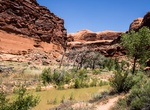
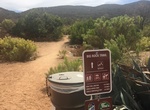
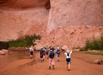
Hike Courthouse Wash, Arches National Park, Utah
Courthouse Wash is within Arches National Park, Utah. Start the hike at either Willow Springs Road or Arches National Park Road. -
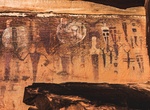
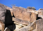
Hike to Courthouse Wash Pictographs, Arches National Park, Utah
The Courthouse Wash Pictographs are a series of large pictographs created over a long period of time, located on a sheltered sandstone wall in Arches National Park, Utah. The series of images depict a variety of figures, many of them anthropomorphic and measuring up to 5 feet (1.5 m) in height. The Courthouse wash site is located near the junction of Courthouse Wash w... -
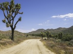
Hike Covington Flats Loop Trail, Joshua Tree National Park
The Covington Flats Loop Trail goes from Lower Covington Flats to Upper Covington Flats, and then back via a short stretch of off trail scramble down through a canyon. -
Hike to Cow Camp, Joshua Tree National Park, California
Cow Camp, located 1/2 mile south of Keys Ranch in Joshua Tree National Park, was associated with cattle rustling in the 1880s and 1890s. It was then later used as a line camp for cattle ranching. A stone chimney, two small dams, watering troughs and a well remain. One dam was built by local rancher and character William F. Keys and is 105 feet long and 30 feet high. A... -
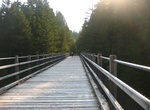
Hike or Ride Cowichan Valley Trail, British Columbia, Canada
The Cowichan Valley Trail is a spectacular multi-use trail that is an integral part of The Great Trail (Trans Canada Trail) route on Southern Vancouver Island. The Cowichan Valley section runs from the Capital Regional District boundary at the top of the Malahat, north to Shawnigan Lake and the Kinsol Trestle, west to the Town of Lake Cowichan then north to the Nanaim... -
Hike Cowles Bog Trail, Indiana Dunes National Park, Indiana
Cowles Bog Trail is reached off of North Mineral Springs Road. Parking is to the east of the guard shack for Dune Acres. This 5-mile (8.0 km) loop is one of the most rugged trails in the park. Visitors begin with a long level walk skirting the wetlands of the Cowles Bog complex and the dune ridges to the north. Following the first fork to the north, they must climb th... -
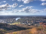
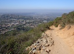
Summit Cowles Mountain, San Diego, California
Cowles Mountain is one of San Diego's most popular hikes with view of the cities coastline from the boarder to North County. Cowles Mountain is a prominent mountain within the city limits of San Diego, California and also within Mission Trails Regional Park, in a neighborhood known as San Carlos, San Diego. The hike to the top is 1.5 miles (2.4 km) long and an el... -
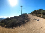
Hike Cowles via Barker Way Trail, San Diego, California
If you wish to avoid the heavily traveled Golfcrest Drive trail to the summit of Cowles Mountain, Barker Way trail is a pleasant alternative. This trail is just one of four that lead to the summit of Cowles Mountain which, at 1591', is the highest points within the city limits of the City of San Diego. "The top of Cowles" as hikers refer to it, provides excellent... -
Hike or Mountain Bike Cowles via Big Rock Trail, San Diego, California
A less busy option for hiking up Cowles Mountain. -
Hike Cowles via Cowles Mountain Trail, San Diego, California
The main trail to the summit is a popular hiking destination taking hundreds of people per day to a 360-degree panorama of San Diego County. The hike to the top is 1.5 miles (2.4 km) long and an elevation change of about 950 feet (290 m). This trail is on the corner of Golfcrest Drive and Navajo Road. -
Hike or Mountain Bike Cowles via Mesa Trail (Service Rd), Santee, California
A less busy option for hiking up Cowles Mountain. This route you will also find a different variety in the landscape with a creek crossings, riparian plants, chaparral-shaded trails, and a meadow crossing. -
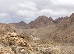
Hike Coxcomb Mountains, Joshua Tree National Park
The Coxcomb Mountains are the most rugged and sharply perpendicular mountains within Joshua Tree National Park. Being in the park's wildest and least-visited northeastern corner, their relative isolation protects their wilderness habitat. There are trails to hike and explore the area. The range is in the ecotone where habitats merge from the higher elevation Mojave De... -
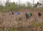
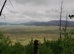
Hike Coyote Call/Rabbit Ridge Trail, Valles Caldera National Preserve, New Mexico
Both the Coyote Call Trail and Rabbit Ridge Extension traverse along the southern rim of the caldera, offering great views of Valle Grande and Redondo Peak.Coyote Call Loop (2.9 miles, 4.7 km round-trip) is shorter with less elevation gain, passing through meadows and aspen groves, and may be hiked in either direction. The east end of the loop can continue into Bandel... -
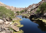
Hike Coyote Gulch Slots Canyons, Utah
Coyote Gulch is a tributary of the Escalante River, located in Garfield and Kane Counties in southern Utah, in the western United States. Over 25 miles (40 km) long, it exhibits many of the geologic features found in the Canyons of the Escalante, including high vertical canyon walls, narrow slot canyons, domes, arches, and natural bridges. A popular recreational desti... -
Hike Coyote Hole Canyon, Joshua Tree, California
Coyote Hole Canyon is located just outside of Joshua Tree Village. The Coyote Hole Petroglyphs are just a few hundred yards from the nearest houses. Coyote Hole is easily accessible and well-known to the locals.
Price: $149.99