Give us feedback!


 See all

Our philosophy is simple. We want to encourage you to dream. BIG! Then we help you plan your trip, get the most out of it while you're traveling and help you share your experience with friends.
Join Now It's FREE
Dream Packages
Duration: 4 days
Price: $772.57
Price: $772.57
Duration: 2 days
Price: $779.00
Price: $779.00
Duration: 6 hours 30 minutes
Price: $167.71
Price: $167.71
Duration: 12 hours
Price: $263.50
Price: $263.50
Related Categories
- Australian National Parks & Reserves
- Canadian National Parks
- Canyoneering
- Day Hikes
- Guided Hikes
- In the Mountains
- Mountaineering
- Mountains
- New Zealand Great Walks
- New Zealand National Parks
- Parks & Reserves
- Rock Climbing
- South African National Parks
- UK National Parks
- UNESCO Parks & Preserves
- US Historical Parks (NHP)
Dreams Still To Do
Checked-Off Dreams
Dreams Still To Do
Checked-Off Dreams
Advertisement
Explore Hikes & Treks
-
Summit Crestone Needle, Sangre de Cristo Range, Colorado
Crestone Needle is a high mountain summit of the Crestones in the Sangre de Cristo Range of the Rocky Mountains of North America. The 14,203-foot (4,329 m) fourteener is located 6.9 miles (11.1 km) east-southeast (bearing 108°) of the Town of Crestone in Saguache County, Colorado, United States. The Crestones are a cluster of high summits in the Sangre de Cristo R... -
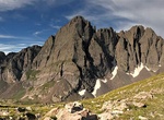
Summit Crestone Peak, Sangre de Cristo Range, Colorado
Crestone Peak is the seventh-highest summit of the Rocky Mountains of North America and the U.S. state of Colorado. The prominent 14,300-foot (4,359 m) fourteener is the highest summit of the Crestones and the second-highest summit in the Sangre de Cristo Range after Blanca Peak. The summit is located in the Sangre de Cristo Wilderness of Rio Grande National Forest, 5... -
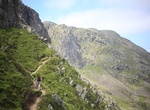
Summit Crinkle Crags, Lake District, England
Crinkle Crags is a fell in the English Lake District in the county of Cumbria. It forms part of two major rings of mountains, surrounding the valleys of Great Langdale and Upper Eskdale. The name reflects the fell's physical appearance as its summit ridge is a series of five rises and depressions (crinkles) that are very distinctive from the valley floor. In Old Engli... -
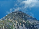
Summit Croagh Patrick (The Reek), Ireland
Croagh Patrick, nicknamed the Reek, is a 764 metres (2,507 ft) tall hill and an important site of pilgrimage in Ireland. The roundtrip trip to the top is about 8 miles. On "Reek Sunday", the last Sunday in July every year, over 15,000 pilgrims climb it. It forms the southern part of a U-shaped valley created by a glacier flowing into Clew Bay in the last Ice Age. Croa... -
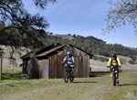
Hike or Ride Cronan Ranch Trail, California
Cronan Ranch Trailhead is located in Pilot Hill, California. The area contains 12 miles of trails for hiking, biking, horseback riding, fishing, bird watching and other passive recreation. There is a wide variety of terrain to choose from, including gently sloped to challenging hills, oak woodland and gentle riverfront trails. Each season offers a diverse experience. ... -
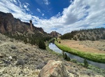
Hike Crooked River Trail, Smith Rock State Park, Oregon
River Trail is a popular 4.3 mile out and back trail along the Croooked River in Smith Rock State Park, Oregon. -
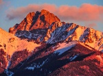
Hike Cross Fell, England
Cross Fell is the highest mountain in the Pennine Hills of Northern England and the highest point in England outside the Lake District. It is located in the North Pennines Area of Outstanding Natural Beauty. The summit, at 2,930 feet (893 m), is a stony plateau, part of a 7.8-mile-long (12.6-kilometre-long) ridge running north-west to south-east, which also incorporat... -
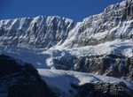
See Crowfoot Glacier, Banff National Park
Crowfoot Glacier is located in Banff National Park, Alberta, Canada, 32 km (20 mi) northwest of Lake Louise, and can be viewed from the Icefields Parkway. The glacier is situated on the northeastern flank of Crowfoot Mountain. Crowfoot Glacier is east of the continental divide, and runoff from the glacier supplies water to the Bow River. The glacier has retreated sinc... -
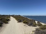
Hike or Mountain Bike Crown Cove Trail, Coronado, California
Crown Cove Trail is a set of dirt trails in the northern portion of Silver Strand State Beach that goes along San Diego Bay and Crown Cove. There is a nice narrow sand beach along the shore. It's 1 mile (1.6 km) loop with a mix of sandy trails and boardwalk. The north entrance is accessible from outside the park. Free parking. -
Hike to Crown Prince Lookout, Joshua Tree National Park, California
Crown Prince Lookout was a warning station for World War II airplanes was located atop a granite formation near today’s overlook. The 3.9 mile lightly trafficked out and back trail starts atJumbo Rocks Campground. This is not a maintained park trail so finding the trailhead at the begging of the hike and the overlooks at the end of the hike requires a little eff... -
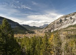
Hike Crow Pass Trail, Girdwood, Alaska
Considered to be one of the best hikes in all of the Chugach Mountains, Crow Pass follows a portion of the original Iditarod Trail, including its highest point. End to end, it’s a 21-mile trail, which most people do in 2 days, but just the first 4 miles will lead you past some breathtaking scenery. 2,100 ft. elevation change from Crow Creek Trailhead; 3,100 ft. ... -
Hike to Crowsnest Pass, Canadian Rockies
Crowsnest Pass is a low mountain pass across the Continental Divide of the Canadian Rockies on the Alberta/British Columbia border. The pass is located in southeast British Columbia and southwest Alberta, and is the southernmost rail and highway route through the Canadian Rockies. It is the lowest-elevation mountain pass in Canada south of the Yellowhead Pass (1,130 m... -
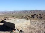
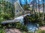
Hike to Crowsnest Pass RCAF DC-3 Dakota Crash Site, BC, Canada
In 1946 an RCAF DC-3 Dakota struck a mountain in bad weather and crashed near the headwaters of North York Creek, killing all seven on board. Remnants of the plane wreckage can still be seen via a moderately difficult hike of 6.2km each way. If you visit, please do not disturb any of the plane wreckage. Take the York Creek Road south from Coleman, and park at the bri... -
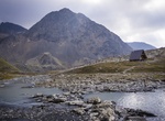
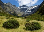
Hike to Crucible Lake, Mount Aspiring National Park, New Zealand
Crucible Lake is locataed in Mount Aspiring National Park in New Zealand. In the summer there are still icebergs floating in the lake. It's a 3-hour hike from the backcountry hut along the Gillespie Pass Circuit. . -
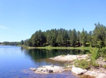
Hike Cruiser Lake Trail, Voyageurs National Park, Minnesota
This trailhead is accessible from either the Rainy or Kabetogama Lake side of the park. This trail crosses over the peninsula, up rocky cliffs and down into remote wetland areas. If you are hoping to spot some of the park's larger wildlife, hiking this trail will increase your chances of spotting a moose or hearing the howl of a wolf. The trail is accessible only by ...
Price: $263.77