Give us feedback!


 See all

Our philosophy is simple. We want to encourage you to dream. BIG! Then we help you plan your trip, get the most out of it while you're traveling and help you share your experience with friends.
Join Now It's FREE
Dream Packages
Duration: 4 days
Price: $772.57
Price: $772.57
Duration: 6 days
Price: $606.00
Price: $606.00
Duration: 12 hours 30 minutes
Price: $289.36
Price: $289.36
Duration: 3 hours 15 minutes
Price: $371.99
Price: $371.99
Related Categories
- Australian National Parks & Reserves
- Canadian National Parks
- Canyoneering
- Day Hikes
- Guided Hikes
- In the Mountains
- Mountaineering
- Mountains
- New Zealand Great Walks
- New Zealand National Parks
- Parks & Reserves
- Rock Climbing
- South African National Parks
- UK National Parks
- UNESCO Parks & Preserves
- US Historical Parks (NHP)
Dreams Still To Do
Checked-Off Dreams
Dreams Still To Do
Checked-Off Dreams
Advertisement
Explore Hikes & Treks
-
Hike to Ehukai Pillbox, Oahu, Hawaii
The Ehukai Pillbox Hike (aka Sunset Pillbox Hike) on Oahu’s North Shore. The trail is similar to the Lanikai Pillbox Trail, but less crowded.. It is located behind the Sunset Elementary School and takes about 30 minutes to climb up to the top. It's a short hike to top of the ridge, but can be a little strenuous. -
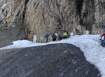
Hike Eiger Ultra Trail, Grindelwald, Switzerland
The Eiger Trail winds its way along the foot of the imposing north face of the Eiger, providing hikers with unparalleled views of the sheer rock walls, glaciers, and surrounding alpine landscapes. This moderate-level hike offers a perfect blend of natural beauty and adrenaline-inducing scenery. As you hike along the trail, you'll be treated to breathtaking views of t... -
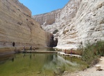
Explore Ein Avdat, Negev Desert, Israel
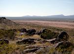
Ein Avdat or Ein Ovdat is a canyon in the Negev Desert of Israel, south of Kibbutz Sde Boker. Archaeological evidence shows that Ein Avdat was inhabited by Nabateans and Catholic monks. Numerous springs at the southern opening of the canyon empty into deep pools in a series of waterfalls. The water emerges from the rock layers with salt-tolerant plants likePoplar tree... -
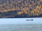
Hike Eklutna Lakeside Trail, Chugach State Park, Alaska
Chugach State Park's EklutnaLakeside Trailtravels 12.7 miles (20.4 kilometers) along the shores of Eklutna Lake until it reaches the mile-longEklutna Glacier Trailthat leads in short order to the moraines at the foot of the colossal blue ice of Eklutna Glacier.In the summer, travelers go on foot, by mountain bike, ATV or on horseback, past the lake by way of largely f... -
Hike El Cajon Mountain Trail, Lakeside, California
El Cajon Mountain, commonly known as El Capitan or El cap, is a mountain and prominent natural landmark in the East County of San Diego. Some considered this the most difficult hike in San Diego county because of its sudden elevation gains and losses on the 6 mile trail. The summit of El Cajon Mountain is at 3648 feet (1112 m). The mountain is almost completely surrou... -
Hike El Camino Real de Tierra Adentro, USA & Mexico (UNESCO site)
El Camino Real de Tierra Adentro National Historic Trail is a part of the United States National Historic Trail system. El Camino Real de Tierra Adentro (Spanish for "The Royal Road of the Interior Land") was a 1,600 mile (2560 kilometer) long trade route between Mexico City and San Juan Pueblo, New Mexico, from 1598 to 1882. The 404 mile (646 kilometer) section of th... -
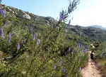
Summit El Cornón, Somiedo Natural Park, Spain
The Cornón is the highest peak of the Parque Natural de Somiedo. The hike to it is a classic ascent via a well-marked path and both during the hike and when we are at the top we have an incredibly beautiful view of the surrounding mountains, which consists of a variety of materials, such as limestone, flint and sandstone. -
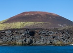
Summit Eldfell, Heimaey, Iceland
Eldfell is a composite volcanic cone just over 200 metres (660 ft) high on the Icelandic island of Heimaey. It formed in a volcanic eruption which began on the eastern side of Heimaey in the Westman Islands on 23 January 1973. This came without any sign of warning. The name of Eldfell meansMountain of Firein Icelandic. The eruption caused a major crisis for the island... -
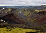
Hike Eldgjá Canyon, Iceland
Eldgjá (Fire Canyon) is a volcano and a canyon in Iceland. Eldgjá and the Katla volcano are part of the same volcanic system in the south of the country. Situated between Landmannalaugar and Kirkjubæjarklaustur, Eldgjá is the largest volcanic canyon in the world, 270 m deep and 600 m wide at its greatest. It was discovered by Þorvaldur... -
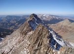
Summit El Diente Peak, Lizard Head Wilderness, Colorado
El Diente Peak is a high summit in the San Miguel Mountains range of the Rocky Mountains of North America. The 14,165-foot (4,317 m) peak is located in the Lizard Head Wilderness of San Juan National Forest, 10.5 miles (16.9 km) north by east (bearing 8°) of the Town of Rico in Dolores County, Colorado, United States. "El Diente" is Spanish for "The Tooth", a refe... -
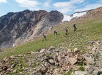
Summit Electric Peak, Yellowstone National Park, Wyoming & Montana
Electric Peak is the tallest mountain in the Gallatin Range of southern Montana, close to the Wyoming border and rises to an altitude of 10,969 feet (3,343 m). The peak has some of the greatest physical relief in Yellowstone National Park, rising 3,389 ft (1,033 m) above its base. Electric Peak was named during the first ascent in 1872 by the United States Geolog... -
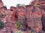
Hike to Elephant Arch, Red Cliffs NCA, Utah
Elephant Arch is a small natural sandstone arch in the Red Cliffs National Conservation Area and Red Cliffs Desert Reserve in northern Washington, Utah. The arch, which resembles the trunk and eye of an elephant, is part way up a hillside at the end of a dirt hiking trail. The arch has not yet been officially named by the United States Geological Survey. -
Hike to Elephant Beach, Havelock Island, Andaman Islands
Elephant Beach is one of the famous beaches perched on Havelock Island. This beach is ideal for snorkelling to see the beautiful corals. -
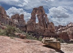
Hike Elephant Canyon/Druid Arch (Chesler Park), Canyonlands National Park, Utah
The Elephant Canyon/Druid Arch trail in the Needles District of Canyonlands National Park offers one of the most spectacular views in the Needles. It follows the Chesler Park access trail to Elephant Canyon, then travels along the canyon bottom across a mixture of deep sand and loose rock all the way to its upper end. The Chesler Trail forks right and climbs out of th... -
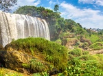
Hike Elephant Mountain, Dalat, Viet Nam
Elephant Mountain is 1756m high and is located 15km from Dalat city centre. There is a love story behind that place and is interesting to get to know it and do the hike afterwards!


Price: $160.26