Give us feedback!


 See all

Our philosophy is simple. We want to encourage you to dream. BIG! Then we help you plan your trip, get the most out of it while you're traveling and help you share your experience with friends.
Join Now It's FREE
Dream Packages
Duration: 4 hours
Price: $129.99
Price: $129.99
Duration: 4 days
Price: $663.61
Price: $663.61
Duration: 4 hours
Price: $129.99
Price: $129.99
Duration: 8 hours
Price: $214.32
Price: $214.32
Related Categories
- Australian National Parks & Reserves
- Canadian National Parks
- Canyoneering
- Day Hikes
- Guided Hikes
- In the Mountains
- Mountaineering
- Mountains
- New Zealand Great Walks
- New Zealand National Parks
- Parks & Reserves
- Rock Climbing
- South African National Parks
- UK National Parks
- UNESCO Parks & Preserves
- US Historical Parks (NHP)
Dreams Still To Do
Checked-Off Dreams
Dreams Still To Do
Checked-Off Dreams
Advertisement
Explore Hikes & Treks
-
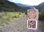
Visit Dunsmore Canyon and Le Mesanger Loop Trails, Glendale, California
The Dunsmore Canyon / Le Mesnager Loop Trail is a 3.2-mile loop that explores Dunsmore Canyon and the Le Mesnager Loop Trail. -
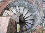
Climb to top of Duomo Nuovo, Siena, Italy
The finest observation point of Siena. A breathtaking panorama. A climb the 132 spiral steps to one of the most important tokens of Siena's history. Gate of Heaven, visit to the roof of the Duomo, Cathedral and Piccolomini's Library€ 15,00 from 03/01 to 10/31 and from 12/26 to 01/10€ 10,00 from 11/01 to 12/24 (from 10:30am to 1:30pm) -
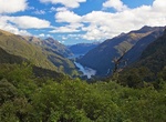
Trek Dusky Track, Fiordland National Park, New Zealand
Dusky Track is a84 kmone way tramping track between Lake Hauroko and Lake Manapouri in Fiordland National Park, New Zealand. This hike crosses three major valley systems and two mountain ranges and provides huge lakes, gushing rivers, vast forested valleys and lots of mud for experienced and well equipped hikers. There are 21 three-wire bridges to cross. You can e... -
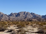
Visit Dyadic Peak Trail (Coxcomb Mountains), California
Dyadic Peak Trail is off State Route 62 (SR 62) on the north side of Coxcomb Mountains. The trailhead has a small, very sandy pull off area. If you don’t have 4WD, stay on the hard pack. The sandy trail is not well marked. This 12.4-mile dayhike or overnighter goes to Joshua Tree National Park's lesser-traveled northeast tip. Good navigation skills required. -
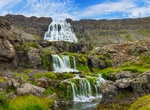
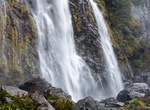
Hike Dynjandi Walking Trail, Iceland
Dynjandi (also known as Fjallfoss) is a set of waterfalls located in Westfjords, Iceland and is considered to be one of the most impressive waterfalls in all of Iceland. The waterfalls have a cumulative height of 100 metres (330 ft). At the top, the waterfall is 98 feet (30 m) wide and as it falls down, it increases to 196 feet (60 m) in width. There is great to clim... -
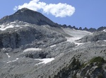
Summit Eagle Cap, Oregon
Eagle Cap (9,577 feet (2,919 m) is located in the Wallowa Mountains, Wallowa-Whitman National Forest, in the U.S. state of Oregon. The peak is in the Eagle Cap Wilderness and the Benson Glacier is along the east flank of the summit ridge. Its summit is the highest point in Union County. The standard approaches for Eagle Cap are considered non-technical. Multiple trail... -
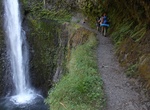
Hike Eagle Creek Falls Trail, Oregon
Punch Bowl Falls is a waterfall on Eagle Creek in the Columbia River Gorge National Scenic Area, Oregon, United States. Eagle Creek drains into the Columbia River, with its outlet on the Columbia River Gorge in Multnomah County. The falls is 35 feet (11 m) tall and 10 feet (3.0 m) wide. Eagle Creek cuts through a narrow channel and shoots powerfully into a large bowl ... -
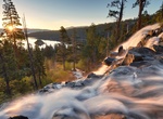
Hike to Eagle Falls & Eagle Lake, Lake Tahoe, California
The hike to Eagle Falls is a strenuous hike but well worth it. The 1.8 mile out and back trail located near Emerald Bay on Lake Tahoe. The views are breathtaking. Parking is pretty difficult and they fill up quickly. -
Hike to Eagle Lake, Sequoia National Park
Eagle Lake, a glacially carved tarn 3.4 miles (one way) from the west side of the Mineral King Valle trailhead. The right-hand trail ends at Mosquito Lake #1, 3.6 miles (one way) from the trailhead, but hikers and fishermen often continue up the drainage to the upper lake. -
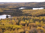
Hike Eagle Mountain, Grand Marais, Minnesota
Eagle Mountain is the highest natural point in Minnesota, at 2,301 feet (701 m). It is located in northern Cook County and is in the Boundary Waters Canoe Area Wilderness and Superior National Forest in the Misquah Hills, northwest of the community of Grand Marais. It is a Minnesota State Historic Site. Eagle Mountain is only about 15 miles (24 km) from Minnesota's lo... -
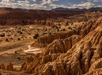
Hike Eagle Point Trail, Cathedral Gorge State Park, Nevada
Follows a ridge line to a bird’s-eye view of the entire park. -
Hike to Eagle Rock via Pacific Crest Trail (PCT), Warner Springs, California
Eagle Rock via the PCT is a 6.4 to 10 mile out and back trail located near Warner Springs, California. The 10 mile trailhead is located off Hwy 79 about a 1.5 miles past Warner Springs you will see a large turn out on the left side of the road. This is the 10 mile Trailhead for Eagle Rock, if you see the airfield you have gone to far. The Pacific Crest Trail is just ... -
Hike, Cycle or Drive Eagles' Nests Trail, Poland
The Trail of the Eagles' Nests of south-western Poland, is a marked trail, named after a chain of 25 medieval castles which the trail passes by, between Częstochowa and Kraków. The Trail of the Eagles' Nests was first marked by Kazimierz Sosnowski. Since 1980, much of the area has been designated a protected area known as the Eagle Nests Landscape Park. The cas... -
Hike Eardley Canyon, San Rafael Swell, Utah
Eardley Canyon is north of Goblin Valley along Utah State Route 24. This trail is usually uncrowded and access to technical canyoneering routes. Non-technical hikers can hike 2.5 miles to the Amazing Pool with out gear. 100-yards beyond the "No Vehicles beyond this point" signs there are two very good petroglyph panels on the right side of the canyon. Eardley Canyon... -
Hike to Earland Falls (Routeburn Track), New Zealand
The hike to Earland Falls is a fabulous, easy day walk on the Routeburn Track. There are plenty of mountain and valley views along the way. The trails starts at The Divide carpark and follows the Routeburn Track.


Price: $1457.59