Give us feedback!


 See all

Our philosophy is simple. We want to encourage you to dream. BIG! Then we help you plan your trip, get the most out of it while you're traveling and help you share your experience with friends.
Join Now It's FREE
Dream Packages
Duration: 3 hours 15 minutes
Price: $371.99
Price: $371.99
Duration: 2 days
Price: $779.00
Price: $779.00
Duration: 6 days
Price: $606.00
Price: $606.00
Duration: 4 days
Price: $1026.70
Price: $1026.70
Related Categories
- Australian National Parks & Reserves
- Canadian National Parks
- Canyoneering
- Day Hikes
- Guided Hikes
- In the Mountains
- Mountaineering
- Mountains
- New Zealand Great Walks
- New Zealand National Parks
- Parks & Reserves
- Rock Climbing
- South African National Parks
- UK National Parks
- UNESCO Parks & Preserves
- US Historical Parks (NHP)
Dreams Still To Do
Checked-Off Dreams
Dreams Still To Do
Checked-Off Dreams
Advertisement
Explore Hikes & Treks
-
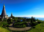
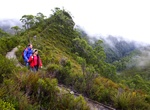
Hike Doi Inthanon Summit, Chiang Mai, Thailand
Doi Inthanon is the highest mountain in Thailand of elevation of over 2500 metres. The hike to reach it is only 3km but takes 2 to 4 hours to complete, depending on pace. Most of the trail leads through dense forest where many kinds of birds can be heard but difficult to see. It's recommended to hire a guide from local tribes who will provide you many useful informati... -
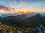
Hike Doi Luang Chiang Dao, Chiang Mai, Thailand
Doi Luang Chiang Dao is Thailand's third highest peak, located about 1.5h drive north from Chiang Mai city. It would be best to split this trail into two days as you can take your time to enjoy all the views on the way. Bring your camping gear, water and snacks as there are limited facilities around. There are also hot springs and caves nearby. -
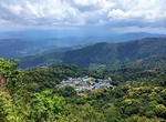
Hike from Doi Pui to Doi Suthep, Chiang Mai, Thailand
This hike starts at Doi Pui mountain and ends at the Doi Suthep temple. The way leads through green forest and local tribes' villages. If you're lucky you might be able to try their delicious coffee! -
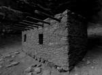
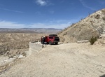
Off-road & Hike to Doll House Ruins, Bears Ears National Monument, Utah
The 800 year old Doll House is located in the Bears Ears National Monument west of Blanding, Utah. It located on a branch of Wooden Shoe Canyon, on the edge of the Dark Canyon Wilderness Area. Constructed by Ancient Pueblan indians around 1260 AD. There are still corn cobs from the original residents in the ruin. Doll House Ruin requires a long drive on dirt roads an... -
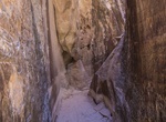
Hike Doll House Slot Canyon, Canyonlands National Park, Utah
Doll House Slot Canyon are located in the Maze District in Canyonlands National Park. Access from Doll House Campsite #2. -
Hike Doll’s Head Trail, Atlanta, Georgia
This unusual trail can be overgrown and be a little creeepy, but it's definately an experience. Joel Slaton, a local carpenter, in 2011 began finding discarded doll parts and other pieces of of “junk” throughout the trail area. Over the years, he began arranging and building art displays with these abandoned scraps to what is there now. -
Off-road or Hike to Dolomite Mine Ruins & Peak, Anza Borrego, California
The Dolomite Mine Ruins are located in Anza Borrego State Park and date back to the 1930s. The peak above the Mine is one of the easiest peaks in the park and considered moderate with some small boulders to enjoy a short scramble across the rock strewn ridge to the rounded summit. The elevation is 1850 feet. There is an impressive overlook across the Carrizo Badlands... -
Hike to Dolphin Point Lookout, Noosa National Park, Queensland
Dolphin Point Lookout is located along the Noosa Coastal Track in Noosa National Park, Queensland. -
Hike or Ride Dominguez Canyon Trail, Dominguez-Escalante National Conservation Area, Colorado
Dominguez Canyon Trail in Dominguez-Escalante National Conservation Area offers a river canyon trail with waterfalls and petroglyphs. -
Hike Donaghys Hill Nature Trail, Franklin-Gordon Wild Rivers National Park, Tasmania, Australia
You’ll want to take your camera on this wonderful walk. Apart from being a great leg stretch for those driving the Lyell Highway between Derwent Bridge and Queenstown, this walk offers superb wilderness views. The 1.1km one-way track climbs gradually through forest and scrub to a high lookout perched on rocky Donaghys Hill. From there, in clear weather, you ca... -
Summit Donaldson Mountain, New York
Donaldson Mountain is a mountain located in Franklin County, New York, named in 1924 after Alfred Lee Donaldson (1866–1923), author ofA History of the Adirondacks. The mountain is part of the Seward Mountains of the Adirondacks. Donaldson Mtn. is flanked to the northeast by Seward Mountain, and to the south by Mount Emmons. Donaldson Mountain stands within the w... -
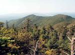
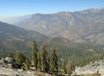
Hike Don Cecil Trail to Lookout Peak, Kings Canyon National Park, California
The Don Cecil Trail climbs the relatively cool north-facing slope of the canyon. This historic trail was the major access route to Cedar Grove prior to the completion of Highway 180 in 1939. Beyond Sheep Creek, the climb to Lookout Peak provides an incredible panorama of the park's backcountry. This strenuous, all-day hike is 13 miles round trip and climbs some 4000... -
Hike Don Cecil Trail to Sheep Creek Cascade, Kings Canyon National Park, California
The Don Cecil Trail climbs the relatively cool north-facing slope of the canyon. This historic trail was the major access route to Cedar Grove prior to the completion of Highway 180 in 1939. A moderately strenuous hike up the forested Don Cecil Trail provides views of the Monarch Divide and leads to a shady glen on Sheep Creek. This two-mile round trip takes about 1 ... -
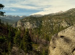
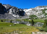
Hike to Donohue Pass, California
Donohue Pass is a high mountain pass on the boundary between Yosemite National Park and the Ansel Adams Wilderness. Its elevation is 11,066 feet (3,373 m). It is situated between Mount Lyell and Donohue Peak. The John Muir Trail and the Pacific Crest Trail both transverse the pass. Following the John Muir Trail, the pass is 6.3 miles (10.1 km) from Thousand Island Lak... -
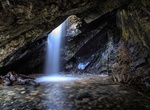
Hike to Donut Falls, Big Cottonwood Canyon, Utah
Donut falls is a very unique waterfall in Big Cottonwood Canyon Utah. The top flows right into the hole of a cave before making its decent down the rest of the falls.

Price: $129.99