Give us feedback!


 See all

Our philosophy is simple. We want to encourage you to dream. BIG! Then we help you plan your trip, get the most out of it while you're traveling and help you share your experience with friends.
Join Now It's FREE
Dream Packages
Duration: 8 hours
Price: $214.32
Price: $214.32
Duration: 4 hours
Price: $129.99
Price: $129.99
Duration: 10 hours
Price: $199.57
Price: $199.57
Duration: 12 hours
Price: $224.21
Price: $224.21
Related Categories
- Australian National Parks & Reserves
- Canadian National Parks
- Canyoneering
- Day Hikes
- Guided Hikes
- In the Mountains
- Mountaineering
- Mountains
- New Zealand Great Walks
- New Zealand National Parks
- Parks & Reserves
- Rock Climbing
- South African National Parks
- UK National Parks
- UNESCO Parks & Preserves
- US Historical Parks (NHP)
Dreams Still To Do
Checked-Off Dreams
Dreams Still To Do
Checked-Off Dreams
Advertisement
Explore Hikes & Treks
-
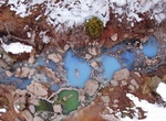
Hike to Diamond Fork (Fifth Water) Hot Springs, Utah
A 2.5-mile hike leads visitors to this picturesque hot spring & waterfall. The access to the trailhead off diamond fork road was closed so access it from the trailhead off Sheep Creek road. The path is a little difficult on the trip back as it was mostly uphill, but doable. -
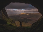
Hike Diamond Head Crater, Oahu Hawaii
Hike to the top of Diamond Head crater, one of the most iconic sites on Oahu. A 0.75-mile (1.1-km) hike leads to the edge of the crater's rim and should take 1½-2 hours. The trail was built in 1908 and was initally used by the military to defend Oahu from invaders. Today hikers climb it to see some of the most spectacular views of the island. Although not diffi... -
Hike Diamond Head Loop Track, Crowdy Bay National Park, Australia
The Diamond Head Loop Track is a 4.3 kilometer hike that offers scenic coastal views across Crowdy Bay National Park. Starting at Diamond Head Camping Ground and continuing to Indian Head, the well-formed track will guide you through hills and forests with breathtaking lookouts. At the southern end of the walk you will get views of the captivating eroding cliff arches... -
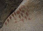
Find Diamonds Solstice Pictographs, Joshua Tree National Park, California
Diamonds Solstice Pictographs can be found in the Wonderland of Rocks area of Joshua Tree National Park. Start at Barker Dam trailhead. Diamond Solstice Pictograph is believed to be a summer solstice marker. The diamond patterns represent the birth canal symbolizing birth. The site is under an overhang up off the valley floor on the north-eastern side of a massive gr... -
Walk Diana, Princess of Wales Memorial Walk, London, England
The Diana, Princess of Wales Memorial Walk is a 7-mile (11 km) long circular walking trail in central London, England, dedicated to the memory of Diana, Princess of Wales. The walk passes between Kensington Gardens, Hyde Park, Green Park and St. James's Park in a figure-eight pattern, passing five sites that are associated with Princess Diana's life: Kensington Palace... -
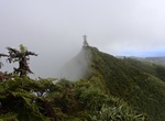
Hike Diana's Peak Ridge, Saint Helena Island
Diana's Peak is the highest point, at 818 metres (2,684 ft), on the island of Saint Helena, a British overseas territory in the South Atlantic Ocean. It is of volcanic origin. The mountain and its surroundings with a total area of 81 ha were proclaimed a national park in March 1996, the first on the island. It is a preserve of several endangered endemic species, inclu... -
Hike to Diarmuid and Grainne's Cave, Sligo, Ireland
Diarmuid and Grainne's cave, the highest cave in Ireland, is located above the cliffs of Annacuna at the back of the Gleniff Horseshoe, the spectacular glacial valley behind Benwisken. -
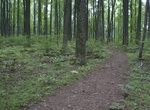
Hike Dickey Ridge Trail, Shenandoah National Park, Virginia
Dickey Ridge Trail is a 18 mileout and back trail in Shenandoah National Park. -
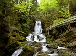
Hike Dickson Falls Trail, Fundy National Park, New Brunswick, Canada
Dickson Falls is 1 km trail and is the most popular trail in Fundy National Park. The hike is nice and the trail/boardwalk well maintained. -
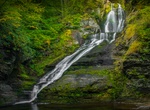
Hike to Dingmans Falls, Pennsylvania
Dingmans Falls is a waterfall located in Dingmans Ferry in Delaware Township, Pike County, Pennsylvania, United States near the Silverthread Falls. It has a vertical drop of 39.6 m (130 ft). Both Silverthread Falls and Dingmans Falls are visible from a handicap-accessible trail. The trail begins at the parking lot for the Dingmans Falls Visitor Center. -
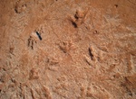
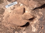
Hike to Dino Cliffs Dinosaur Tracks, Washington, Utah
Dino Cliffs Dinosaur Tracks is a great, short hiking trail for families of all ages! The first part of the trail is a little bit sandy, but doesn’t last too long. At the bottom out on the trail a slate rock surface in part of the stream bed to the left of the trail. In the hardened sedimentary rock you can find 17 well preserved dino tracks presumed to be from G... -
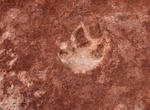
Hike to Dinosaur Dance Floor (Dinosaur Trackway), North Coyote Buttes, Arizona
The dinosaur trackway within the area is a site of 0.75 acres (3,000 m2) that has densely packed dinosaur footprints within the area. The trackway contains more than 1,000 footprints which were made approximately 190 million years ago. Tracks of three genera of Eubrontes, Anchisauripus and Grallator are present along with a Sauropodomorph that has not been identified.... -
Hike Dinosaur Ridge, Colorado
Dinosaur Ridge is a segment of the Dakota Hogback in the Morrison Fossil Area National Natural Landmark located in Jefferson County, Colorado, near the town of Morrison and just west of Denver. The Dinosaur Ridge area is one of the world's most famous dinosaur fossil localities. In 1877, some of the best-known dinosaurs were found here, includingStegosaurus,Apatosauru... -
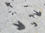
Hike to Dinosaur Stomping Grounds, Moab, Utah
A gradual up-hill hike to the tracks (3 miles round trip). The trail parallels a mountain bike trail for a short distance before branching off on its own. Follow the rock cairns and trail to the dinosaur tracks. From Moab, go north on Highway 191 for 23 miles. Turn right 3/4 mile past milepost 148. Cross the railroad tracks and follow the main road for 1 mile. Take... -
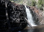
Hike to Dip Falls & Big Tree, Tasmania, Australia
The Dip Falls, a cascade waterfall over cubic-basalt formed rocks on the Dip River, is located in the North West region of Tasmania, Australia. The waterfall is situated in the Dip Range Regional Reserve at an elevation of 218 metres (715 ft) above sea level and descends in the range of 22–34 metres (72–112 ft), near the village of Sisters Beach and approx...


Price: $341.00