Give us feedback!


 See all

Our philosophy is simple. We want to encourage you to dream. BIG! Then we help you plan your trip, get the most out of it while you're traveling and help you share your experience with friends.
Join Now It's FREE
Dream Packages
Duration: 6 days
Price: $606.00
Price: $606.00
Duration: 4 days
Price: $772.57
Price: $772.57
Duration: 12 hours
Price: $154.81
Price: $154.81
Duration: 13 hours 30 minutes
Price: $572.77
Price: $572.77
Related Categories
- Australian National Parks & Reserves
- Canadian National Parks
- Canyoneering
- Day Hikes
- Guided Hikes
- In the Mountains
- Mountaineering
- Mountains
- New Zealand Great Walks
- New Zealand National Parks
- Parks & Reserves
- Rock Climbing
- South African National Parks
- UK National Parks
- UNESCO Parks & Preserves
- US Historical Parks (NHP)
Dreams Still To Do
Checked-Off Dreams
Dreams Still To Do
Checked-Off Dreams
Advertisement
Explore Hikes & Treks
-
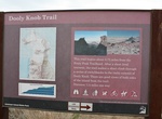
Hike Dooly Knob Trail, Antelope Island State Park, Utah
The trail to Dooly Knob on Antelope Island. The trailhead is shared with the hike to Frary Peak. Hiking is pretty easy and the trail is clearly marked. -
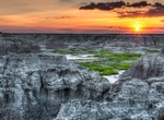
Hike Door Trail, Badlands National Park, South Dakota
An accessible ¼ mile boardwalk leads through a break in the Badlands Wall known as "the Door" and to a view of the Badlands. From there, the maintained trail ends. Travel beyond this point is at your own risk. Watch for drop-offs. The Door Trail is a great place to capture sunrise photos. -
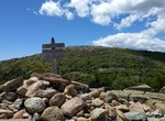
Summit Dorr Mountain, Acadia National Park, Maine
Hike to the summit of Dorr Mountain in Acadia National Park. There are several trails lading to the summit including: South Ridege Dorr Trail North Ridge Dorr Trail Ladder Trail/East Face Dorr Trail (Schiff Path) - pets not allowed on this trail. George Path -
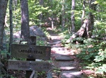
Hike Dorr Mountain Loop, Acadia National Park, Maine
Hike to Dorr Mountain via Ladder Trail to Schiff Path and return via South Ridge Dorr Trail to Canon Brook Trail. Stone steps and iron rungs to open ridge and forest. Starts/ends at: ME 3, at the south end of The Tarn Round-trip distance: 3.3 miles (5.3 km) -
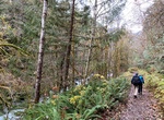
Hike Dosewallips River Trail, Olympic National Forest, Washington
Dosewallips River Road Trail is a 12.6 mile out and back trail located near Brinnon, Washington that features a waterfall and is rated as moderate. The trail is primarily used for hiking, running, camping, and nature trips. -
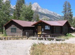
Camp at Double Diamond Dude Ranch Dining Hall, Grand Teton National Park
The Double Diamond Dude Ranch Dining Hall was built in 1945 as the centerpiece of a dude ranch operated by Frank Williams and Joseph S. Clark, Jr. in Grand Teton National Park. The ranch was opened in 1924 with a dozen tent cabins and log buildings for a kitchen and dining hall, lounge and commissary. In 1943 Williams built log tourist cabins, followed by the larger d... -
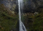
Hike Double Falls, South Falls, Silver Falls State Park, Oregon
Remote Double Falls, however, is listed as the highest waterfall in the park, plunging 178 feet (54 m) in a small tributary side canyon deep within the Silver Creek Canyon. Double Falls is the tallest of the waterfalls in Silver Falls State Park. It is located along the Trail of Ten Falls (mile 2.1 on the trail + 0.1 on side trail), along Canyon Trail, a few yards fr... -
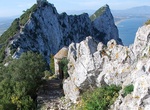
Hike Douglas Path, Gibraltar
Douglas Path is a path that connects a series of military installations at the top of the Rock of Gibraltar. It leads from the top of Charles V Wall to Mount Misery, one of the peaks of the Rock, before proceeding southwards to end at Douglas Cave. The first section of the path climbs a steep set of steps before running along a knife-edge ridge. It has views over both... -
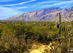
Hike or Ride Douglas Spring & Arizona Trail, Saguaro National Park, Arizona
Douglas Spring Trail is a long but easy trail that offer views of a waterfall at Bridal Wreath Falls. Just before reaching the Douglas Spring Campground the trail will merge with the Arizona Trail, The Douglas Spring Trailhead is located at the east end of Speedway Boulevard and is accessible 24 hours per day. Due to this easy access, vehicle break-ins have occurred a... -
Hike Dragon's Back, Hong Kong
The Dragon's Back is a mountain ridge in southeastern Hong Kong Island, Hong Kong that passes through Shek O Peak. It lies within the Shek O Country Park. In 2019, the Dragon's Back Trail was selected by CNN as one of the world's 23 best trails. Dragon's Back is part of Stage 8 of the Hong Kong Trail. Most of the route is on dirt paths. The first half has very little ... -
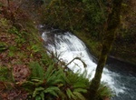
Hike to Drake Falls, Silver Falls State Park, Oregon
Drake Falls, is a 27-foot (8 m) tall waterfall located in the Silver Falls State Park at the east end of the city of Salem, in Marion County, in the U.S. state of Oregon. It is located in a privileged area on the west foothills where Mount Hood National Forest meets with the Middle Santiam Wilderness. Several prominent waterfalls are located in the Park along Trail of... -
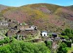
Hike to Drave (The Magic Village), Arouca Geopark, Portugal
Drave, the "Magic Village" (A Aldeia Mágica) is lost in the mountain, without inhabitants. Everything here is close to the pure and untouchable state. -
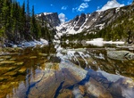
Hike to Dream Lake, Rocky Mountain National Park, Colorado
Dream Lake is a high alpine lake located in Rocky Mountain National Park in northern Colorado, located east of the continental divide. The lake is at the base of Hallett Peak and access is via the popular Bear Lake trail head. It is well known for its stunning views caused by surrounding steep cliffs, and a popular destination for casual hiking. -
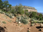
Hike Dripping Springs Trail, Grand Canyon National Park, Arizona
The Dripping Springs Trail is a 2 mi (3 km) hiking trail on the South Rim of the Grand Canyon National Park, located in the U.S. state of Arizona. The trail begins along the Hermit Trail. The Dripping Springs Trail Junction is located in Hermit Basin, near the top of the Supai Formation about 1.6 miles (2.5 km) from the Hermit Trailhead. The elevation change to t... -
Hike Driskill Mountain, Bienville Parish, Louisiana
Driskill Mountain (also referred to as Mount Driskill) is the highest natural summit in Louisiana, with an elevation of 535 feet (163 m) above sea level. It lies about 5.3 miles (8.5 km) southeast of Bryceland, Louisiana. It is located in the northeastern corner of Sec. 32, T. 17 N., R. 5 W. within Bienville Parish. Driskill Mountain is a landform created by the erosi...

Price: $129.99