Give us feedback!


 See all

Our philosophy is simple. We want to encourage you to dream. BIG! Then we help you plan your trip, get the most out of it while you're traveling and help you share your experience with friends.
Join Now It's FREE
Dream Packages
Duration: 14 hours
Price: $341.00
Price: $341.00
Duration: 4 days
Price: $1457.59
Price: $1457.59
Duration: 12 hours
Price: $263.50
Price: $263.50
Duration: 6 days
Price: $606.00
Price: $606.00
Related Categories
- Australian National Parks & Reserves
- Canadian National Parks
- Canyoneering
- Day Hikes
- Guided Hikes
- In the Mountains
- Mountaineering
- Mountains
- New Zealand Great Walks
- New Zealand National Parks
- Parks & Reserves
- Rock Climbing
- South African National Parks
- UK National Parks
- UNESCO Parks & Preserves
- US Historical Parks (NHP)
Dreams Still To Do
Checked-Off Dreams
Dreams Still To Do
Checked-Off Dreams
Advertisement
Explore Hikes & Treks
-
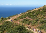
Participate in Dipsea Race, Mill Valley, California
TheDipsea Raceis a trail running event in California, United States. It is the oldest cross-country trail running event and one of the oldest foot races of any kind—in the United States. The 7.5 mile (12 km) long Dipsea Race has been held annually almost every year since 1905, starting in Mill Valley, and finishing at Stinson Beach, in Marin County. The Dipsea c... -
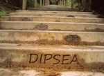
Climb Dipsea Stairs (Dipsea Trail), Mill Valley, California
Hike, run, or hobble up the shaded 688 steps of the Dipsea Stairs. Encouraging notes (“Don’t stop now!” “Live life fully!” “Run, Carl, Run!”) embedded in bronze plaques will cheer you on your way up the stairs leading out of Mill Valley. There is a lot of beauty and scenery along the 7.2 mile trail. -
Explore Discovery Park, Seattle, Washington
Discovery Park is a 534 acre natural area park operated by the Seattle Parks and Recreation. It is the largest city park in Seattle, and occupies most of the former Fort Lawton site. The site is one of breathtaking majesty. Situated on Magnolia Bluff overlooking Puget Sound, Discovery Park offers spectacular view of both the Cascade and the Olympic Mountain ranges. Th... -
Hike Discovery Trail (Ancient Bristlecone Pine Forest), California
Discovery Trail is a 0.9 mile loop trail next to Schulman Grove Visitor Center in Ancient Bristlecone Pine Forest. -
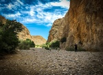
Hike Dismals Canyon, Phil Campbell, Alabama
Dismals Canyon is a sandstone gorge near Phil Campbell in Franklin County, Alabama. It was declared a National Natural Landmark in May 1974. Dismals Canyon is one of only a few places where insects called dismalites (Orfelia fultoni, a distant relative of Arachnocampa) can be found. The larval forms of these flies emit a bright blue-green light to attract food and mat... -
Hike to Divide Creek, British Columbia/Alberta, Canada
Divide Creek is a short creek near Kicking Horse Pass on the British Columbia/Alberta border (also the border between Yoho National Park and Banff National Park). After following the Continental Divide of the Americas for a short distance, the creek forks, with one side draining through the Bow River east to Hudson Bay and the Arctic Ocean, and the other side draining... -
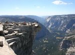
Hike to Diving Board, Yosemite National Park, California
The Diving Board is just off the face of Half Dome in Yosemite National Park. This is an hard 12.5 mile out and back hike with intense scrambling, hard-to-find cairns and should plan on camping overnight at the spot is a good idea. Monolith, the Face of Half Dome, Yosemite National Park, California is a black and white photograph taken by Ansel Adams in 1927 that dep... -
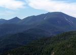
Summit Dix Mountain, New York
Dix Mountain is the sixth highest peak in the High Peaks Region of the Adirondack Park, and is located roughly on the boundary between the towns of North Hudson and Keene in Essex County, New York. The peak was named in 1837 after John Dix (1798–1879), who was the Secretary of State of New York at the time, and later became the state's governor. While it stands ... -
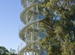
Climb DNA Tower, Perth, Western Australia
Built on the highest point of the park in 1966, the DNA Tower is a white 15 m (49 ft) high double helix staircase that has 101 steps and was inspired by a double staircase in the Château de Blois in France. Its design resembles the deoxyribonucleic acid (DNA) molecule. The paving below the DNA Tower is made with stones sent from 11 towns and 80 shires in Western... -
Hike Dobson Trail, Fundy National Park, Canada
The Dobson Trail is a 57.75 km trail from Riverview to Fundy National Park in Canada. The trail goes through woodland terrain with rooks and meadows. The Dobson Trail meets Fundy National Park at the Old Sheapody Road and joins the Park’s Laverty Falls Trail just west of the Broad River via the Dobson Link Trail. The trail takes about 3 days but there are lots ... -
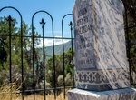
Hike to Doc Holliday's Grave, Glenwood Springs, Colorado
Steep 1/4 mile path leading up to the gravesite of gunslinger Doc Holliday in Linwood Cemetery. "Doc was a dentist whom necessity had made a gambler; a gentleman whom disease had made a frontier vagabond; a philosopher whom life had made a caustic wit; a long, lean ash-blond fellow nearly dead with consumption, and at the same time the most skillful gambler and the n... -
Hike Dog Canyon, Guadalupe Mountains National Park, Texas
Dog Canyon in Guadalupe Mountains National Park lies in a secluded, forested canyon on the north end of the park at an elevation of 6,300 feet. Remote and far removed from civilization; it stands at the edge of the wilderness boundary, and offers an ideal location for quiet camping, birding, hiking, and solitude. Due to its higher elevation and protected location ben... -
Hike Dog Canyon Trail, Big Bend National Park, Texas
Dog Canyon Trail is a 4.3 mile out and back trail located near Chisos Basin in Big Bend National Park. The trail starts across a flat open desert marked by cairns for more than a mile to the canyon. The trail starts at Devil's Den Trailhead and the hike can combine both Devil's Den and Dog Canyon. -
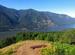
Hike Dog Mountain, Washington
Dog Mountain rises above the north side of the Columbia River Gorge in the U.S. state of Washington. The base of the mountain is in Skamania County along Washington State Route 14, about 9 miles (14 km) east of Stevenson and 53 miles (85 km) east of Vancouver. From its base at 150 feet (46 m), it climbs steeply to an elevation of 2,948 feet (899 m). The mountain is th... -
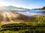
Hike Doi Ang Khang, Chiang Mai, Thailand
Doi Ang Khang is a mountain in Fang District, Chiang Mai Province, Thailand. It is part of the Daen Lao Range that straddles both sides of the Burmese-Thai border. It is the site of an agricultural station, the first research station set up by King Bhumibol Adulyadej in 1969. The peak of Doi Ang Khang is 1,928 metres (6,325 ft) above sea level, and the agricultural s...
Price: $663.61