Give us feedback!


 See all

Our philosophy is simple. We want to encourage you to dream. BIG! Then we help you plan your trip, get the most out of it while you're traveling and help you share your experience with friends.
Join Now It's FREE
Dream Packages
Duration: 10 hours
Price: $199.57
Price: $199.57
Duration: 3 hours 15 minutes
Price: $371.99
Price: $371.99
Duration: 30 minutes
Price: $263.77
Price: $263.77
Duration: 8 hours
Price: $214.32
Price: $214.32
Related Categories
- Australian National Parks & Reserves
- Canadian National Parks
- Canyoneering
- Day Hikes
- Guided Hikes
- In the Mountains
- Mountaineering
- Mountains
- New Zealand Great Walks
- New Zealand National Parks
- Parks & Reserves
- Rock Climbing
- South African National Parks
- UK National Parks
- UNESCO Parks & Preserves
- US Historical Parks (NHP)
Dreams Still To Do
Checked-Off Dreams
Dreams Still To Do
Checked-Off Dreams
Advertisement
Explore Hikes & Treks
-
Hike Desert Gardens, Anza-Borrego Desert State Park, California
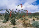
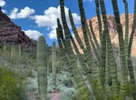
Desert Gardens is a nice set of ocotillo, cactus, and other desert plants located on the eastern side of Coyote Canyon. -
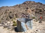
Hike to Desert Queen Mine (Queen Valley Road), Joshua Tree National Park, California
The Desert Queen Mine in the Colorado Desert was one of the more long-lived gold mines of Southern California's high desert region. Desert Queen Mine is located off Queen Valley Road in Joshua Tree National Park, California. The area also has some petroglyph, but not eay to find. The abandoned mine is located in Riverside County, California within the boundaries of th... -
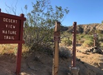
Hike Desert View Nature Trail, Red Rock Canyon State Park, California
Desert View Nature Trail is a short hike located at the southern end of Ricardo Campground in Red Rock Canyon State Park. -
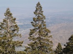
Hike Desert View Trail, San Jacinto Mountain, California
The Desert View Trail can be reached at the top of the Palm Springs Tram in the San Jacinto Mountains. This 1.5 mile (2 km) loop trail leads to a number of scenic overlooks and forest views. Short climbs, moderately strenuous. -
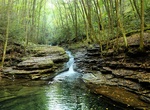
Hike Desolation Canyon, Death Valley National Park, California
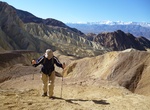
Desolation Canyon is a 3.6 mile (5.8km) out and back round trail in Death Valley National Park. From the parking area there are two obvious canyon drainages. Avoid the small canyon to the south; instead begin hiking east toward the Black Mountains. The short unpaved Desolation Canyon Road is located 3.7 miles (6km) south of CA-190 on Badwater Road. Typically passable... -
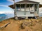
Hike to Desolation Peak Lookout, Washington State
Desolation Peak is in the North Cascade Mountains of Washington state, about 6.2 miles (10.0 km) south of the Canada–United States border and in the Ross Lake National Recreation Area. It was first climbed in 1926 by Lage Wernstedt, who named it for the destruction caused by a forest fire that swept the slopes bare that same year. At the summit stands a small, w... -
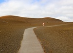
Hike Devastation Trail, Hawaii Volcanoes National Park, Hawaii
Devastation Trail is a trail at Hawaiʻi Volcanoes National Park. The trail, which is paved, allows visitors to explore the site of 1959 eruption of Kīlauea Iki crater. Before the 1959 eruption of Kīlauea Iki, the area that is now designated Devastation Trail was covered by a dense rain forest. Devastation Trail is located off Chain of Craters Road in Hawaiʻi Volcanoes... -
Hike to Devil's Bathtub, Virginia
The Devil’s Fork Loop Trail takes you on a 7.2 miles round trip hike across stream beds, past Cascade Falls and to the Devils Bathtub, -
Hike Devil's Bathtub Trail, Spearfish Canyon, South Dakota
Devil's Bathtub Trail is a 1.6-mile out-and-back trail in Spearfish Canyon, near Spearfish, South Dakota. -
Hike to Devil's Bay, Virgin Gorda, BVIs
Devil's Bay is a picturesque small cove and beach on Virgin Gorda's south-western tip. The beach is great for swimming and snorkelling. Mooring buoys and a dinghy dock allow boaters to access the beach. There are two ways to hike to the bay. The easy one is a 15-minute hike over dry scrub vegetation and boulders from the car park at the top of the Baths. The more diff... -
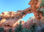
Hike Devil's Bridge Trail, Sedona, Arizona
Devil's Bridge is the largest natural sandstone arch in the Sedona area. The trailhead elevation of 4,600 feet, there's a mere 400 foot climb in altitude during this moderately difficult, 1.8-mile roundtrip trek. After you've walked about three-quarters of a mile from the parking area, the trail will divide. Head down the path to the left and you'll end up at the bas... -
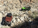
Off-road & Hike Devils Canyon & Meyer Creek Loop, San Diego County, California
Devils Canyon runs from Mountain Springs, off Interstate 8, to Ocotillo just East of the San Diego/Imperial County line. Descend Devils Canyon eastward to the desert floor, then loop around to follow Meyer Creek back up. This parallels and crisscrosses the eastbound lanes of Interstate 8. This offers a chance to explore sections of the old 1915 concrete highway. From... -
Hike to Devil’s Causeway, Colorado
The Devil's Causeway, a narrow strip of land in the heart of the Flat Tops Wilderness Area. It's pretty narrow in the middle section – roughly roughly 50 feet in length and three to four feet wide and is notorious for causing sheer terror for those who dare to cross it. Devil's Causeway trail is a 6 mile out and back trail located near Yampa, Colorado. -
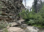
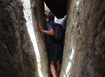
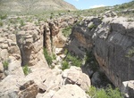
Hike Devil's Den Slot Canyon, Big Bend National Park, Texas
Devil's Den is a dramatic limestone slot canyon in the park's northern backcountry. Follow the trail towards Dog Canyon. After 1.5 miles take a side trail off to the right into a wash. In another 0.5 mile, take the large wash that intersects from the left which leads directly into Devil's Den. You may hike into the den, or hike up along the southern edge of the deep c...
Price: $779.00