Give us feedback!


 See all

Our philosophy is simple. We want to encourage you to dream. BIG! Then we help you plan your trip, get the most out of it while you're traveling and help you share your experience with friends.
Join Now It's FREE
Dream Packages
Duration: 2 days
Price: $779.00
Price: $779.00
Duration: 12 hours
Price: $263.50
Price: $263.50
Duration: 6 hours 30 minutes
Price: $167.71
Price: $167.71
Duration: 6 to 10 hours
Price: $86.83
Price: $86.83
Related Categories
- Australian National Parks & Reserves
- Canadian National Parks
- Canyoneering
- Day Hikes
- Guided Hikes
- In the Mountains
- Mountaineering
- Mountains
- New Zealand Great Walks
- New Zealand National Parks
- Parks & Reserves
- Rock Climbing
- South African National Parks
- UK National Parks
- UNESCO Parks & Preserves
- US Historical Parks (NHP)
Dreams Still To Do
Checked-Off Dreams
Dreams Still To Do
Checked-Off Dreams
Advertisement
Explore Hikes & Treks
-
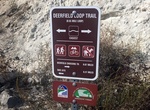
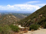
Hike or Ride Deerfield BMX Loop Trail, Mission Trails Park, San Diego, California
Hike or mountain bike the Deerfield BMX Loop Trail in Mission Trails Regional Park. Either start at the Visitor Center or from the San Diego River Crossing Staging Area. It's mile oout and back from visitor center. -
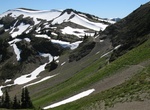
Hike Deer Park-Obstruction Point Trail, Olympic National Park, Washington
7.4 mile trail through Obstruction Point: subalpine forests and moutain meadows. The trail starts at 5,380 feet and ends at 6,150, with a high point at 6,650. -
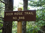
Hike Deer Ridge Trail, Olympic National Park, Washington
Deer Ridge Trail starts at Three Forks Trail and splits after 0.2 mile. Dropping 400 feet, the first 1.5 miles take you to the park boundary. The trail continues for another 3.1 miles to Slab Camp, in Olympic National Forest. Total elevation loss is 2,856 feet. There is a restroom near the trailhead. -
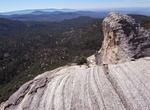
Hike Deer Springs Trail To Suicide Rock, San Jacinto Mountain, California
The hike to Suicide Rock in the San Jacinto Mountains along Deer Springs Trail is a good mix of forest, rocks and views. The trail to Suicide Rock is a branch off Deer Springs Trail. This 6.5 mile roundtrip hike is somewhat challenging due to rocks and elevation. It starts at 5,600 ft and ends at 7,300 ft. About a half mile up the Deer Springs trail you will enter int... -
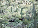
Hike or Ride Deer Valley Loop, Saguaro National Park, Arizona
From the trailhead, proceed south on Wildhorse Trail. After crossing Bajada Wash enjoy the views of upland saguaro forest. Horse riding has been traditional here since the early 1900’s among residents & visitors. At the triple trail junction bear right on Garwood Trail. Unusual saguaros seen in this area have included a 4-trunker, a cluster of 13 (at first ... -
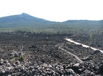
Hike Dee Wright Observatory Lava Trail, Oregon
Dee Wright Observatory, built completely of lava rocks, offers fantastic views to all the surrounding volcanoes. Following the loop trail through the lava field you will feel like you are in moon landscape. It's hard to believe that this much lava erupted from the earth around you! Make sure you take the time to read all the interesting interpretive signs on the trail... -
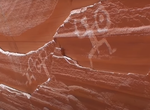
Boat & Hike to Defiance House (Forgotten Canyon), Lake Powell, Utah
Defiance House is located in Forgotten Canyon on Lake Powell. Defiance House is named after the warrior pictographs on the cliff above the ruin. Defiance House was occupied by Anasazi (Ancestral Puebloans) from approximately A.D. 1250 to 1285. Take a boat from Bullfrog, approximately. 40 minutes,15 miles (24 km) by water. Boat into Forgotten Canyon as far as lake leve... -
Hike Del Dios Gorge Trail (Lake Hodges Dam), San Diego, California
Del Dios Gorge Trail is a 10.4 mile out and back trail that goes from Lake Hodges Dam down Del Dios Gorge to Rancho Santa Fe. -
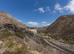
Explore Del Dios Highlands County Preserve, Escondido, California
Set amid 774 acres of open space in Escondido, Del Dios Highlands County Preserve is an inviting place to see and experience nature. As part of the County of San Diego’s Multiple Species Conservation Program (MSCP) the County partnered with the Escondido Creek Conservancy and the San Dieguito River Park Joint Powers Authority to acquire the parkland, restore it,... -
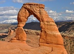
Hike Delicate Arch Trail, Arches National Park, Utah
Delicate Arch is a 65-foot (20 m) tall freestanding natural arch located in Arches National Park near Moab, Utah, USA. It is the most widely-recognized landmark in in the park. The 3 miles (4.8 km) roundtrip hike to Delicate Arch has a 480 feet (146 meters) elevation gain and take 2-3 hours. The best part was the fact that the arch is hidden until the last minute as ... -
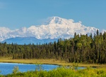
Summit Denali (McKinley), Alaska
Denali, formerly named Mount McKinley from 1917 to 2015, is the highest mountain peak in North America, with a summit elevation of 20,237 feet (6,168 m) above sea level. At some 18,000 ft (5,500 m), the base-to-peak rise is considered the largest of any mountain situated entirely above sea level. Measured by topographic prominence, it is the third most prominent peak ... -
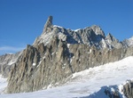
Explore Dent du Géant, Mont Blanc Massif, France & Italy
The Dent du Géant (It.: Dente del Gigante, "giant's tooth") (4,013 m) is a mountain in the Mont Blanc massif in France and Italy. The Dent du Géant remained unclimbed during the golden age of alpinism, and was a much-coveted peak in the 1870s, repelling many parties who attempted it mostly from the Rochefort ridge. In 1880 the strong team of Albert F. Mu... -
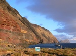
Visit Desertas Islands, Madeira
The Desertas Islands ("Deserted Islands") are a small archipelago, in the Macaronesia region of the Atlantic Ocean. They are within the Portuguese Autonomous Region of Madeira, and part of the larger Madeira Archipelago. The archipelago is located off the coast of Morocco, roughly between Madeira Island and the Canary Islands. Deserta Grande Island is located about 25... -
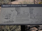
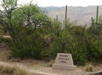
Hike Desert Discovery Nature Trail, Saguaro National Park, Arizona
You will find the trailhead to this self-guided nature trail on Kinney Road, 1 mile northwest of the Red Hills Visitor Center. Exhibits discuss the native plants, animals and ecology of the Sonoran Desert. This paved trail is wheelchair accessible and offers resting benches and shade ramadas. -
Hike Desert Ecology Trail, Saguaro National Park, Arizona
An easy stroll through the desert beside Javelina Wash. Signs along the way will introduce you to the residents of this Sonoran Desert “neighborhood.” This trail is wheelchair accessible & leashed pets are OK.
Price: $160.26