Give us feedback!


 See all

Our philosophy is simple. We want to encourage you to dream. BIG! Then we help you plan your trip, get the most out of it while you're traveling and help you share your experience with friends.
Join Now It's FREE
Dream Packages
Duration: 30 minutes
Price: $263.77
Price: $263.77
Duration: 4 hours
Price: $149.99
Price: $149.99
Duration: 6 hours 30 minutes
Price: $167.71
Price: $167.71
Duration: 12 hours
Price: $154.81
Price: $154.81
Related Categories
- Australian National Parks & Reserves
- Canadian National Parks
- Canyoneering
- Day Hikes
- Guided Hikes
- In the Mountains
- Mountaineering
- Mountains
- New Zealand Great Walks
- New Zealand National Parks
- Parks & Reserves
- Rock Climbing
- South African National Parks
- UK National Parks
- UNESCO Parks & Preserves
- US Historical Parks (NHP)
Dreams Still To Do
Checked-Off Dreams
Dreams Still To Do
Checked-Off Dreams
Advertisement
Explore Hikes & Treks
-
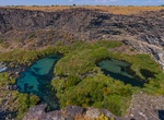
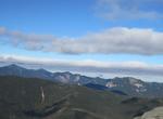
Explore Earl M. Hardy Box Canyon Springs Nature Preserve, Thousand Springs State Park, Idaho
This 350-acre (140 ha) box canyon has 250-foot-high (76 m) walls. At its head is the eleventh-largest spring in North America, gushing 180,000 US gallons (680,000 L) per minute. There is a 20-foot (6.1 m) waterfall. The 350-acre (140 ha) property was developed by the Nature Conservancy which purchased the site in 1999, then completed its transfer to the state in 2016.... -
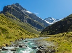
Hike Earnslaw Burn Track, Glenorchy, New Zealand
Following Earnslaw Burn through bush to the tussock basin at the head of this valley for impressive views of an icefall on Mt Earnslaw/Pikirakatahi. Follow the Earnslaw Burn Track through the bush to a viewpoint. This viewpoint has impressive views of an icefall on Mt Earnslaw/Pikirakatahi at the edge of the forest where the track ends. For shelter an overhanging roc... -
Hike Earthquake Trail, Point Reyes National Seashore, California
The Earthquake Trailhead is located at the northeast end of the Bear Valley Trailhead parking lot. The Earthquake Trail is a 0.6-mile-long (1-kilometer-long) nature trail with exhibits about the San Andreas Fault Zone and the 1906 San Francisco Earthquake. -
Hike East Bison Flats Trail, Wind Cave National Park
The East Bison Flats Trail is located in the southern end of Wind Cave National Park. This 3.7 miles (6 km) hike (one way) begins a ½ mile down the Wind Cave Canyon Trail (which your start near the east of the visitor center). This mildly strenuous trail leads hikers across the rolling hills of the prairie. From this trail you may see panoramic views of Wind C... -
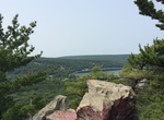
Hike East Bluff Trail, Devil's Lake State Park, Wisconsin
A trail with periodic stone steps ascending; the most gradual way up the bluff (but still gains 500 feet elevation). All in the woods with scenic vistas of the lake. Elephant Rock and Elephant "Cave" along the way. The trail can also be reached from the Balanced Rock Trail (Ice Age Trail). -
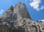
Rock Climb East Buttress, Middle Cathedral Rock, Yosemite National Park
The East Buttress Route is a technical climbing routes up Middle Cathedral Rock. The route is recognized in the historic climbing text Fifty Classic Climbs of North Americaand considered a classic around the world. -
Hike to East Cape Lighthouse, New Zealand
East Cape Lighthouse is a lighthouse sited on Otiki Hill above East Cape, the easternmost point on the North Island of New Zealand. It is owned and operated by Maritime New Zealand. The lighthouse was originally constructed on nearby East Island. However the island was difficult to access (four men died during tower construction when their boat capsized) and proved to... -
Hike or Bike East Coast Greenway, Florida to Maine
The East Coast Greenway (ECG) is a project to create a nearly 3,000-mile (4,800 km) urban greenway/rail trail linking the major cities of the Atlantic coast of the United States, from Calais, Maine, to Key West, Florida, for non-motorized human transportation. The "spine route" and branching "complementary routes" are meant to be safe avenues for long bike rides, or e... -
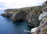
Hike East Coast Trail, Newfoundland, Canada
The East Coast Trail is a 540 kilometres (340 mi) hiking trail located in the Canadian province of Newfoundland and Labrador. Located primarily on public lands, the trail traces the east coast of Newfoundland along the Atlantic Ocean. The trail passes through many small coastal towns nested in the bays of the Avalon Peninsula between St. John's and Cappahayden. Major ... -
Summit East Dix, New York
East Dix is a mountain located in Essex County, New York. It is one of the 46 Adirondack High Peaks and is located in the Adirondack Park. The northwest side of East Dix drains into the headwaters of the South Fork of the Boquet River, thence into Lake Champlain, which drains into Canada's Richelieu River, the Saint Lawrence River, and into the Gulf of Saint Lawrence... -
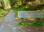
Hike East Fork Quinault River Trail to Enchanted Valley, Olympic National Park, Washington
East Fork Quinault River Trail to Enchanted Valley is a 30.8 mile out and back trail near Graves Creek Ranger Station and Graves Creek Campground. It's 2.5 miles to Pony Bridge and 6.5 miles to O'Neil Creek. Beyond Enchanted Valley are O'Neil Pass Juntion (16.7 miles), Anderson Pass (18.4 miles) and Dosewallips Trailhead (34.3 miles). The emergency shelter at Enchan... -
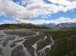
Explore East Fork River, Denali National Park, Alaska
Steep-sided, glacial valleys deep in the Alaska Range define the southern portions of this unit. The East Fork River originates from a large headwater glacier and flows north to the Park Road. Its wide, brush-free gravel river bar is surrounded by open tundra hillsides and small drainages filled with willow. The entire unit is above tree line. The Upper East Fork Riv... -
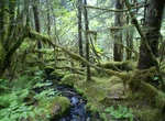
Hike East Glacier Loop (Mendenhall Glacier), Alaska
East Glacier Loop branches off from the Trail of Time. Visitors starting the Trail of Time from the second parking lot will intersect the East Glacier Loop at a Civilian Conservation Corps shelter. Visitors starting the Trail of Time from the Visitor Center will intersect the East Glacier Loop. Offers glacier view, 100-200 years forest growth and information about hy... -
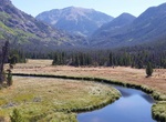
Hike East Inlet Trail, Grand Lake, Colorado
TheEast Inlet Trailin Rocky Mountain National Park, Colorado, was established in 1913 to provide access from Grand Lake to a series of lakes 6 miles (9.7 km) to the east of Grand Lake. The trail originates at the east stream inlet to Grand lake: confusingly, it is close to the west portal of the Alva B. Adams Tunnel which conveys water from the west side of the Contin... -
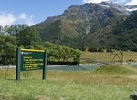
Hike East Matukituki Valley Tracks, Mount Aspiring National Park, New Zealand
The East Matukituki Valley provides interesting day walks and access to several demanding tramping and climbing routes in Mount Aspiring National Park. The main track up the East Branch of the Matukituki River provides several options. It connects with a side track to the Glacier Burn, and continues up the river to Junction Flat. From Junction Flat there's a sid...

Price: $663.61