Give us feedback!

Our philosophy is simple. We want to encourage you to dream. BIG! Then we help you plan your trip, get the most out of it while you're traveling and help you share your experience with friends.
Join Now It's FREE
Dreams Still To Do
Checked-Off Dreams
Dreams Still To Do
Checked-Off Dreams
Advertisement
Explore Landmarks (Natural)
-
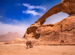
See The Rock Bridge of Kharaz, Wadi Rum, Jordan
The Rock Bridge of Kharaz is a 112-foot span in the northern Wadi Rum Desert of Jordan. -
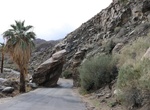
Drive through The Rock Drive-Thru (Split Rock), Palm Springs, California
Narrow section of South Palm Canyon Drive between two tall rocks. -
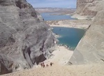
Climb The Sandhill, Lake Powell, Utah
The Sandhill can only be accessed when the water level is high enough to boat to the base of the massive hill of sand. It can be found in a small inlet on north side of Wahweap Bayfrom Stateline Launch Ramp. -
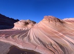
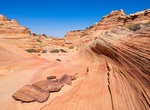
Hike to The Second Wave (Wave 2), Coyote Buttes North, Arizona
The Second Wave (Wave 2) is located a thousand feet southwest of the Wave and maybe 100 feet higher. It's more curvy sandstone crossed by small fins. The light for the main Wave is best in early or mid-morning. For The "Second Wave", shown above, late afternoon is best. BLM a daily permit is required, with no time limit otherwise. They do say "Day use only", but I t... -
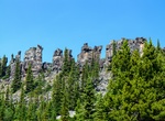
Hike The Shipyard and Titanic Rock, Tumbler Ridge, BC, Canada
The 4 km return trail is rated moderate and has interpretive signage describing the formation of the towers. There are some anchors for rock climbing installed on the Titanic rock. -
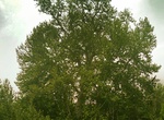
See The Shirin and Farhad Tree, Kermanshah, Iran
The Shirin and Farhad Tree or Rahmat tree (Dār-e Šīrīn-o Farhād) is a 700-year-old tree of the genus Platanus located in the historical area of Taq Bostan in Kermanshah, Iran. The tree is 37.7 metres (124 ft) tall and 8.46 metres (27.8 ft) wide. -
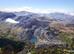
Explore The Slate Landscape of Northwest Wales (UNESCO Site)
The Slate Landscape of Northwest Wales illustrates the transformation that industrial slate quarrying and mining brought about in the traditional rural environment of the mountains and valleys of the Snowdon massif. The territory, extending from mountain-top to sea-coast, presented opportunities and constraints that were used and challenged by the large-scale industri... -
Visit The Southernmost Tip of Canada, Point Pelee National Park, Ontario, Canada
Point Pelee National Park forms the southernmost point in mainland Canada (its latitudinal position is the same as the northernmost counties of California) and is part of a bird and butterfly migration corridor over Lake Erie via Point Pelee and the Lake Erie islands. -
See The Southern Wave, Cottonwood Cove, Coyote Buttes South, Arizona
The Southern Wave is located in Cottonwood Cove, Coyote Buttes South, Arizona -
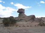
See The Sphynx (La Esfinge), Ischigualasto Provincial Park, Argentina
The Sphynx is a wind-eroded rock formation in Ischigualasto Provincial Park, Argentina. -
See The Submarine, Ischigualasto Provincial Park, Argentina
The Submarine is a rock formation in the UNESCO World Heritage Ischigualasto Park in Argentina. -
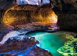
Hike or Canyoneer The Subway, Zion National Park, Utah
The Subway is a colloquial name for a uniquely-shaped slot canyon in Zion National Park. The Subway is so named for its tube-like, undercut slot canyons. This segment of canyon is less than a quarter-mile in length, but long approach and exit hikes are necessary for access. Left Fork (Subway) Bottom-Up Hiking Route: This is a very strenuous 9-mile round-trip hike ... -
See The Survivor Tree, 9/11 Memorial, New York City
A callery pear tree recovered from the rubble at the World Trade Center site in October 2001 was later called the "Survivor Tree". When the 8-foot (2.4 m)-tall tree was recovered, it was badly burned and had one living branch. The tree had been planted during the 1970s near buildings four and five, in the vicinity of Church Street. Then-Memorial president Joe Daniels ... -
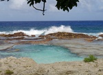
Swim at The Swimming Hole, Rota Island, Northern Mariana Islands
Swimming Hole Beach is situated northwest of Sinapalu, and northwest of Rota International Airport. -
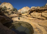
Hike to The Tanks (Capitol Gorge Trail), Capitol Reef National Park, Utah
The Tanks can be found along the Capitol Gorge Trail in Capitol Reef National Park. The Tanks is a series of waterpockets accessible by a short spur trail off the gorge. There are s hort distance east of Pioneer Register.