Give us feedback!

Our philosophy is simple. We want to encourage you to dream. BIG! Then we help you plan your trip, get the most out of it while you're traveling and help you share your experience with friends.
Join Now It's FREE
Dreams Still To Do
Checked-Off Dreams
Dreams Still To Do
Checked-Off Dreams
Advertisement
Explore Landmarks (Natural)
-
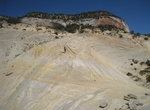
Hike to The White Wave, Utah
The White Wave is above Red Canyon Slot (Peekaboo Kanab) in Utah. It's a unique place to spend some time to explore the cliffs and rocks around. -
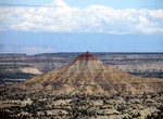
See The Wickiup, San Rafael Swell, Utah
The Wickiup is located three miles north of Interstate 70 in the San Rafael Swell. This small mountain has an unique form, shape and colors. The Wickiup is one of the higher points in the San Rafael Swell at 6,982 feet. -
Hike The Windows Trail, Arches National Park, Utah
The Windows Arches (also known as North Windows Arch & South Windows Arch) are two arches that are formed of the same sandstone fin, one of the farthest reaches of the collection that sits below Elephant Butte. A gentle climb up a gravel trail leads to the massive North Window, South Window, and Turret Arch. Return to the parking lot via the same trail, or take th... -
See Thimmamma Marrimanu, Kadiri, Andhra Pradesh, India
Thimmamma Marrimanu (Thimmamma's Banyan Tree) is a banyan tree in Anantapur, located about 25 kilometers from Kadiri, Andhra Pradesh, India. It is probably a specimen of Ficus benghalensis. In the Telugu language, "marri" denotes "banyan" and "manu" denotes "trunk". Its canopy covers 19,107 m2 (4.721 acres), and it was recorded as the largest tree specimen i... -
See Thor's Hammer, Bryce Canyon National Park, Utah
Thor's Hammerin Bryce Canyon National Park is a hoodoos rock formation that looks like a sledgehammer. Hoodoos are tall skinny spires of rock that protrude from the bottom of arid basins and "broken" lands. It is one of the most popular formations along the Navajo Trail. -
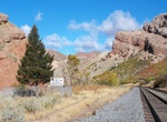
See Thousand Mile Tree, Utah
Thousand Mile Tree is a pine tree located in Weber Canyon near the community of Henefer, Utah along the Overland Route of the Union Pacific Railroad. In January 1869, graders of the railroad found a similar tree standing next to the line they were constructing, which by coincidence marked the western progress of exactly one thousand miles of road from Omaha, Nebraska/... -
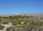
Explore Thousand Palms Oasis Preserve, California
Enjoy picnicking, hiking and our rustic visitor Center, the "Palm House." On the northern side of the Coachella Valley, nestled at the feet of the Indio Hills, the Coachella Valley Preserve is "The Old West" just minutes from Palm Springs, Indian Wells, Rancho Mirage, Palm Desert, Indio and other desert cities. Enjoy some of the 20,000+ acres of desert wilderness, wil... -
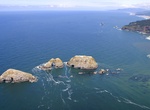
Birding at Three Arch Rocks National Wildlife Refuge, Oregon
Three Arch Rocks National Wildlife Refuge is a U.S. National Wildlife Refuge off the northern Oregon Coast. It is located on the central coast of Tillamook County, in the northwestern part of Oregon. It is one of six National Wildlife Refuges within the Oregon Coast National Wildlife Refuge Complex and was the first National Wildlife Refuge west of the Mississippi Riv... -
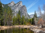
See Three Brothers, Yosemite National Park
The Three Brothers is a rock formation, in Yosemite Valley, California. It is located just east of El Capitan and consists of Eagle Peak (the uppermost "brother"), and Middle and Lower Brothers. John Muir considered the view from Eagle Peak to be the most beautiful view of Yosemite Valley available. -
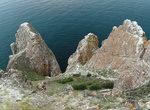
See Three Brothers Rock (Sagaan-Khushun Cape), Olkhon Island, Lake Baikal, Siberia
Three Brothers Rock, or Sagaan-Khushun Cape, is one of Baikal's natural monuments and another popular tourist sightseeing spot. It is easily recognised as three big rocks standing in a row overlooking Lake Baikal. According to an old Buryatian legend, there once lived three brothers on Olkhon Island whose father had supernatural powers. Once, their father turned them ... -
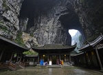
Explore Three Natural Bridges Area, China (UNESCO site)
The Three Natural Bridges is a series of natural limestone bridges located in Xiannushan Town, Wulong County, are the nucleus of a 22 km2 (8.5 sq mi) conservation area which includes the following features: Tianlong Qinglong and Heilong limestone bridges Qinglong Tiankeng Shenying Tiankeng Yangshui River Karst Canyon Longshui Gorge Central Shiyuan Tiankeng Lower Shiy... -
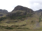
See Three Sisters Of Glencoe, Scotland
The Three Sisters Of Glencoe is named for the three distinctive ridges on the Bidean Nam Bian Mountain. It's the most photographed landmark in Glencoe. -
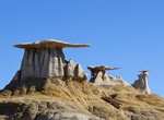
See Three Wings Hoodoos & Klingon Bird of Prey Arch, Bisti Badlands, New Mexico
Stone Wings (Flying Wings, Three Wings) is is located past the Beige Hoodos with the Bisti Badlands. Other than the Eggs, the Stone Wings are probably Bisti’s most famous photo op. The middle wing is also an arch called Klingon Bird of Prey Arch. From below it also looks like a seal. -
Drive Through Wawona Tunnel, Yosemite National Park
The Wawona Tunnel is a highway tunnel in Yosemite National Park. It, and Tunnel View just beyond its east portal, were completed in 1933. Wawona Tunnel was bored through solid granite bedrock, and carries Wawona Road through a granite mountain on the south side of the Merced River. It is located on one of the three main roads providing access to Yosemite Valley, the m... -
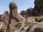
See Thumb Rock, Joshua Tree National Park, California
Thumb Rock is located along Split Rock Trail in Joshua Tree National Park.