Give us feedback!

Our philosophy is simple. We want to encourage you to dream. BIG! Then we help you plan your trip, get the most out of it while you're traveling and help you share your experience with friends.
Join Now It's FREE
Dreams Still To Do
Checked-Off Dreams
Dreams Still To Do
Checked-Off Dreams
Advertisement
Explore Landmarks (Natural)
-
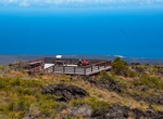
Visit Kealakomo Overlook, Hawaii Volcanoes National Park, Hawaii
Kealakomo (The entrance path) in Hawaii Volcanoes National Park has panoramic view of the Pacific Ocean and an expansive view of the vast lava field that covered portions of the ancient village of Kealakomo. The overlook is along the Chain of Craters Road. -
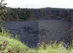
Hike to Keanakākoʻi Crater, Hawaii Volcanoes National Park, Hawaii
Not a drive but you can hike .8 miles to Keanakāko'i Crater. Hawai'i Volcanoes National Park has reopened the section of Crater Rim Drive near the Devastation Trail parking lot to Keanakāko'i Crater, and a portion of Crater Rim Trail that leads from Chain of Craters Road to the south side of Keanakāko'i to foot traffic only. This area has been closed since the er... -
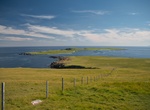
Explore Keen of Hamar, Shetland, Scotland
Keen of Hamar is a nature reserve on Unst, in Shetland, Scotland, managed by Scottish Natural Heritage. The reserve is primarily of botanical interest, for example for populations ofCerastium nigrescens, a plant unique to Unst. Keen of Hamar was designated a special area of conservation on 17 March 2005. It is also a site of special scientific interest. The site is of... -
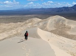
Hike or Sandboard Kelso Dunes, Mojave National Preserve, California
Kelso Dunes, also known as the Kelso Dune Field, is the largest field of eolian sand deposits in the Mojave Desert. Hikers at sunrise and sunset are treated to both cooler temperatures and the rose-colored glow of the dunes. The roughly 3-mile round-trip hike might take several hours as you slog through the sand, then slide down the slopes. Moving sands sometimes crea... -
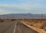
Explore Kelso Mountains, Mojave National Preserve, California
The Kelso Mountains are located just north of the small community of Kelso and the Kelso Dunes, in the Mojave National Preserve in southeastern California. The town of Baker, near Interstate 15, lies approximately 18 miles (29 km) to the northwest of the mountain range. Kelso Peak, at 4,764 feet (1,452 m), is the principal peak of the range. Like most of the Mojave De... -
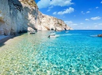
Explore Keri Cliffs, Zakynthos Island, Greece
Keri Coast offers turquoise sea next to the steep cliffs along the southern part of Zakynthos Island, Greece. This location is famous for its sunset. -
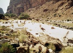
Hike to Keyhole Natural Bridge via 140-Mile Canyon, Grand Canyon National Park, Arizona
Keyhole Natural Bridge in Grand Canyon National Park is located in Redwall Limestone in a very remote tributary of 140-Mile Canyon. It has an approximate span of 40 feet and height of 100 feet. It is narrower but taller than Royal Arch and can be called the third largest natural bridge in Grand Canyon. -
Explore Keyhole Sink, Arizona
Keyhole Sink is a canyon in the shape of a keyhole near Williams, Arizona. The canyon is best known for its petroglyphs, which were created about 1,000 years ago by the ancient Cohonina people, and the seasonal waterfalls that flow into the canyon. Keyhole Sink, formerly called Box Canyon, is a few miles east of Williams off Route 66 in Kaibab National Forest, and can... -
See View From Keys View, Joshua Tree National Park, California
Joshua Tree's highest viewpoint, offering panoramic views of mesas, mountains & Coachella Valley. This popular destination, perched on the crest of the Little San Bernardino Mountains, provides panoramic views of the Coachella Valley and is well worth the 20-minute drive from Park Boulevard down Keys View Road. The southwest side of the ridge drops nearly a mile ... -
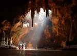
Visit Khao Luang Cave Temple, Thailand
Khao Luang Cave Temple is located near Phetburi, Thailand. The cave is just a few miles from town, beautiful inside and very peaceful. -
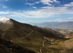
Visit Khardung La (Khardung Pass), Ladakh, India
Khardung La or Khardung Pass is a mountain pass in the Leh district of the Indian union territory of Ladakh. The pass is on the Ladakh Range, north of Leh, and connects the Indus river valley and the Shyok river valley. It also forms the gateway to the Nubra valley, beyond which lies the Siachen Glacier. A motorable road through the pass was built in 1976, and op... -
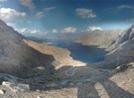
Explore Khawr Najd (Khor Najd), Musandam Peninsula, Oman
Khawr Najd (Khor Najd) is an excellent spot for overnight camping. The view from top of mountain is breath-taking beautiful. It can be reached either by traditional sea vessels (4 hours) from Khasab through the Strait of Hormuz, or by four-wheel drives along a beautiful mountain road (30 minutes). -
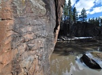
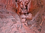
Hike Khazali Slot Canyon, Wadi Rum, Jordon
Khazali Canyon is a narrow slot canyon in Wadi Rum. Although the canyon is much longer, you only visit the first 100 meters. The first part contains numerous petroglyphs and inscriptions that decorate the walls at different heights. It's the most visited canyon in the Wadi Rum so be prepared for crouds. -
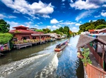
Long-Boat through Khlong Bangkok Yai (West Canals), Bangkok, Thailand
Khlong Bangkok Yai is a historic khlong (คลอง; canal) of Bangkok. Originally it was part of the Chao Phraya River, In the past, Chao Phraya River has a more tortuous condition than present. Those who travel by boat must cruise along the river, which takes more than one day. It's a waste of time. Until in the reign of King Chairachathirat (1534–46) of Ayutthaya K... -
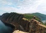
See Khoboy Cape, Olkhon Island, Lake Baikal, Siberia
Khoboy Cape is the most northern point of Olkhon island. The name comes from an old Buryat word meaning "fang" because of its shape, a vertically oriented marble rock, appearing much like a fang.