Give us feedback!

Our philosophy is simple. We want to encourage you to dream. BIG! Then we help you plan your trip, get the most out of it while you're traveling and help you share your experience with friends.
Join Now It's FREE
Dreams Still To Do
Checked-Off Dreams
Dreams Still To Do
Checked-Off Dreams
Advertisement
Explore Landmarks (Natural)
-
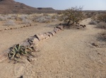
Visit Khorixas Petrified Forest, Namibia
The Petrified forest, located 42 kilometres (26 mi) west of the Namibian town of Khorixas, on the C39 road, is a deposit of large tree trunks that have "turned to stone" through a process of diagenesis. There are at least two large tree trunks, each 45 metres (148 ft) long, exposed to view. Several hundred others are located in the vicinity. It is believed that the tr... -
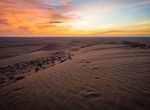
Explore Khulais Sand Dunes, Saudi Arabia
Explaore the san dunes around Khulais, Saudi Arabia. -
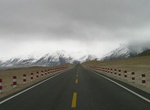
Explore Khunjerab Pass, China & Pakistan
Khunjerab Pass is a 4,693-meter-high (15,397 ft) mountain pass in the Karakoram Mountains, in a strategic position on the northern border of Pakistan (Gilgit–Baltistan's Hunza and Nagar Districts) and on the southwest border of China (Xinjiang). Mutsjliga Pass [ceb] is a 5,314-meter-high (17,434 ft) mountain pass near Khunjerab Pass. Its name is d... -
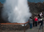
See Kiama Blowhole, New South Wales, Australia
The Kiama Blowhole is a blowhole in the town of Kiama, New South Wales, Australia. It is the town's major tourist attraction. Under certain sea conditions, the blowhole can spray water up to 25 metres (82 ft) in the air, in quantities that thoroughly drench any bystanders. There is actually a second, less famous blowhole in Kiama, commonly referred to as the "Little B... -
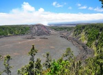
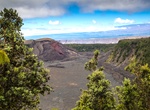
See Kīlauea Iki Crater, Hawaii Volcanoes National Park
Kīlauea Iki is a pit crater which is next to the main summit caldera of Kīlauea. In August 1959, a swarm of deep earthquakes was detected by the Hawaiian Volcano Observatory. In October it was indicated by seismographs that Kilauea summit was filling with magma. This formed a new lava shield, named Pu'u Pua'i (gushing hill). Lava fountain Some of the most impressive p... -
Visit Kīlauea Iki Overlook, Hawaii Volcanoes National Park, Hawaii
Continuing along Crater Rim Drive you come to Kīlauea Iki Overlook. Alternately, the driver could drive to the Overlook and the rest of the party could walk a 1/2 mile section of the Crater Rim Trail to the Overlook. This is also an option when the Thurston Lava Tube parking area is full. Kīlauea Iki looks fairly tranquil these days. But, in 1959 it was a seething la... -
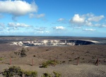
Visit Kīlauea Overlook, Hawaii Volcanoes National Park, Hawaii
The Kīlauea Overlook is located on the left side of Crater Rim Drive, approximately .7 miles from Steaming Bluffs. The road sign indicates that this a picnic area. Which it is, but it is also a splendid overlook of the Kīlauea Caldera and Halema'uma'u Crater. The view here is similar to that found at the Jaggar Museum, but is usually much less crowded. And, it is a ni... -
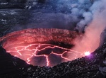
Explore Kīlauea Volcano, Hawaii
Kīlauea is a volcano in the Hawaiian Islands, and one of five shield volcanoes that together form the island of Hawaiʻi. It's world's most active volcano. Kīlauea means "spewing" or "much spreading" in the Hawaiian language, referring to its frequent outpouring of lava. The Puʻu ʻŌʻō cone has been continuously erupting in the eastern rift-zone since 1983, making it th... -
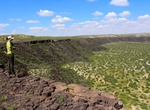
See Kilbourne Hole, New Mexico
Kilbourne Hole is a maar volcanic crater, located 30 miles (48 km) west of the Franklin Mountains of El Paso, Texas, in the Potrillo volcanic field of Doña Ana County, New Mexico. Another maar, Hunt's Hole, lies just two miles south of Kilbourne Hole. Kilbourne Hole is notable for the large number of mantle xenoliths, solid fragments of mantle rock, that were c... -
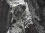
Visit Killing Caves of Phnom Sampeau, Battambang, Cambodia
The killing caves of Phnom Sampeau are a Khmer Rouge execution site on Phnom Sampeau, a hill 7 mi (11 km) southwest of Battambang in western Cambodia. The Khmer Rouge killed their victims on top of the cave at the rim of a daylight shaft or ceiling hole and then threw the dead body into the cave. Men and women were placed in separate caves and clothes in another. Ther... -
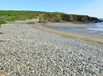
Visit Kilmurrin Cove & Beach, Ireland
Coastal cliffs and fields, with a blowhole included. Car parking is possible at Kilmurrin Cove. It's park of the Copper Coast Geopark. -
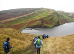
Explore Kilpatrick Hills, Scotland
The Kilpatrick Hills are a range of hills in central Scotland, stretching from Dumbarton in the west to Strathblane in the east. Strathblane divides the Kilpatricks from the Campsie Fells to the east, while to the north is part of the Loch Lomond and the Trossachs National Park. To west and south the hills are fringed by the settlements of Balloch, Dumbarton, Milton, ... -
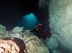
Snorkel or Dive Kilsby Sinkhole, Mount Gambie, South Australia
The Kilsby sinkhole is a sinkhole located near Mount Gambier in South Australia. Since the late 1960s, the naturally occurring karst sinkhole has been used for recreational diving as well as civilian and police diver training. The sinkhole is located on private property owned by the Kilsby family since the late 19th century. Due to insurance and liability concerns, ac... -
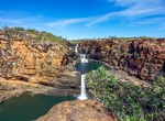
Explore Kimberley, Western Australia
The Kimberley is the northernmost of the nine regions of Western Australia. It is bordered on the west by the Indian Ocean, on the north by the Timor Sea, on the south by the Great Sandy and Tanami Deserts in the region of the Pilbara, and on the east by the Northern Territory. The region was named after John Wodehouse, 1st Earl of Kimberley, who served as Secretary o... -
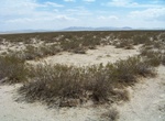
See King Clone Ring, Mojave Desert
King Clone is thought to be the oldest creosote bush ring in the Mojave Desert. The ring is estimated to be 11,700 years old, making it one of the oldest living organisms on Earth. This single clonal colony plant ofLarrea tridentatareaches up to 67 feet (20 metres) in diameter, with an average diameter of 45 feet (14 m). The King Clone ring is on restricted-access lan...