Give us feedback!

Our philosophy is simple. We want to encourage you to dream. BIG! Then we help you plan your trip, get the most out of it while you're traveling and help you share your experience with friends.
Join Now It's FREE
Dreams Still To Do
Checked-Off Dreams
Dreams Still To Do
Checked-Off Dreams
Advertisement
Explore Landmarks (Natural)
-
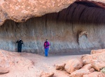
Visit Kitchen Cave, Uluru-Kata Tjuṯa National Park, Northern Territory, Australia
The Kitchen Cave is a wave-shaped rock formation along Mala Walk at base of Ayers Rock in Uluru-Kata Tjuta National Park, where the ancient Aboriginal women used to cook. -
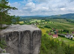
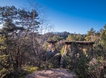
Visit Klokočské & Betlémské skály Rocks, Czechia
Lookout points in the Klokočské and Betlémské skály Rocks offer beautiful views of the Jizera River valley, the Besedické and Suché skály Rocks, the Hamštejnský hřeben Ridge and Kozákov. -
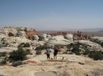
See Klondike Bluffs, Arches National Park
Klondike Bluffs is located in Arches National Park and can be seen along the Tower Arch Trail. -
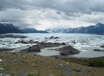
See Knik Glacier, Alaska
The Knik Glacier is an ice field located 50 miles (80 km) east of Anchorage, Alaska on the northern end of the Chugach Mountains. The ice field averages over 25 miles (40 km) long and over 5 miles (8.0 km) across, making it one of the largest glaciers in southcentral Alaska. Knik Glacier feeds the 25-mile (40 km) long Knik River which empties ... -
Explore Knockan Crag, Scotland
Knockan Crag lies within the North West Highlands Geopark in the Assynt region of Scotland 21 kilometres (13 mi) north of Ullapool. During the nineteenth century Knockan Crag became the subject of much debate when geologists noted that the Moine schists at the top of the crag appeared to be older than the Cambrian and Ordovician rocks such as Durness limestone lower d... -
Visit Knockmahon & Stage Cove, Ireland
The site comprises coastal cliffs and the bay at Stage Cove, and Knockmahon beach to the east of it. It's park of the Copper Coast Geopark. -
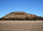
Visit Kokerbin Rock, Western Australia
Kokerbin Rock, also known as Kokerbin Hill, is a granite rock formation located within the Kokerbin Nature Reserve in the Wheatbelt region of Western Australia. The area has special significance for Noonga. There are claims that Kokerbin Rock is the third largest monolith in Australia, with Mount Wudinna in South Australia being the second largest and Uluru in th... -
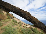
Hike to Koko Crater Arch, Oahu, Hawaii
Koko Crater Arch Trail starts from Halona Blowhole Lookout is a 0.9 mile loop trail. The trail is across lava rock and ends at an amazing natural arch with views of the Southeast side of Oahu. -
See Kokořínské Pokličky, Czech Republic
Kokořínské pokličky (Kokorinske poklicky) a rock formation in Kokorinsko (Kokořínsko) a protected landscape area in Czech Republic. -
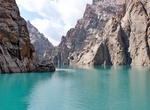
Explore Köl-Suu, Kyrgyzstan
Köl-Suu is an alpine lake in At-Bashy District of Naryn Region of southeastern Kyrgyzstan. It is located at 3514 m elevation in the Kakshaal Too mountain range, central Tian Shan. It is fed and drained by the river Kurumduk, a left tributary of the Kök-Kyia [ky], which is a right tributary of the Kakshaal. It is 5 km long, and its area is 4.5 km2 (1.7 sq mi)... -
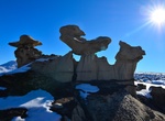
See Komainu (Lion-Dog), Bisti Badlands, New Mexico
Komainu (Lion-Dog) is another rock formation within the Bisti Badlands. -
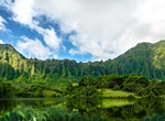
Explore Koʻolau Range, Oahu, Hawaii
Koʻolau Range is a name given to the dormant fragmented remnant of the eastern or windward shield volcano of the Hawaiian island of Oʻahu. It was designated a National Natural Landmark in 1972. It is not a mountain range in the normal sense, because it was formed as a single mountain called Koʻolau Volcano (koʻolaumeans "windward" in Hawaiian, cognate of the toponymTo... -
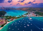
Visit Ko Phi Phi Don Island, Krabi, Thailand
Ko Phi Phi Don is the largest of the islands in the Ko Phi Phi archipelago, in Thailand. Phi Phi Don is 9.73 km2 (3.76 mi2): 8 kilometres (5.0 miles) in length and 3.5 kilometres (2.2 miles) wide. Part of the islands are administratively part of Ao Nang in Krabi Province. It is the only island in the group with permanent inhabitants, although most are temporary worker... -
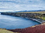
Birding at Krýsuvíkurbjarg Cliffs, Iceland
Krýsuvíkurbjarg is a rock that rises from the sea in Krýsuvíkraun on the south of the Reykjanes Peninsula. The mountain is the tallest birdwatch of the peninsula. A breeding ground for 60,000 fuglapör, and also guillemot, razorbill, Brünnich's, puffins, Shags, gulls and black guillemot. -
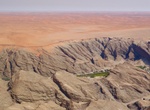
Explore Kuiseb Canyon, Namibia
Kuiseb Canyon contains the Kuiseb River, which is no more than a broad sandy riverbed for most of the year.