Give us feedback!


 See all

Our philosophy is simple. We want to encourage you to dream. BIG! Then we help you plan your trip, get the most out of it while you're traveling and help you share your experience with friends.
Join Now It's FREE
Dream Packages
Duration: 2 days
Price: $398.24
Price: $398.24
Duration: 12 hours
Price: $160.26
Price: $160.26
Duration: 9 hours
Price: $88.47
Price: $88.47
Duration: 5 days
Price: $726.42
Price: $726.42
Dreams Still To Do
Checked-Off Dreams
Dreams Still To Do
Checked-Off Dreams
Advertisement
Explore Man-Made Sites
-
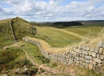
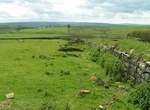
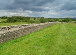
Visit Milecastle 37 (Cuddy's Crags) Hadrian's Wall, England
Milecastle 37 is one of the milecastles on Hadrian's Wall. It is immediately west of the Housesteads Roman Fort (grid reference NY78506869). The remains have been partly reconstructed and consolidated; it is now in the care of English Heritage. The wall has a maximum height of 2.2 metres internally. The milecastle has a short axis, with a Type I gateway. The milecastl... -
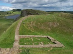
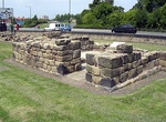
Visit Milecastle 39 (Castle Nick) & Peel Gap Tower (Hadrian's Wall), England (UNESCO site)
Milecastle 39 (Castle Nick) is a milecastle on Hadrian's Wall (grid reference NY76066773). Milecastle 39 is located northeast of Once Brewed. The excavated stonework has been consolidated, and the walls are up to 1.75 metres high. It measures 19 metres by 15.5 metres. The site was cleared in 1854, and was excavated in 1908-11. It was re-excavated between 1982 and 1987... -
Visit Milecastle 40 Winshields (Hadrian's Wall), England (UNESCO site)
Milecastle 40 (Winshields) was a milecastle on Hadrian's Wall (grid reference NY74566758). Milecastle 40 is located northwest of Twice Brewed, just below the top of Winshields. The milecastle can be seen as turf-covered rubble banks up to 1.0 metre high. The milecastle was excavated in 1908. The remains were greatly disturbed but the south wall was still ten courses h... -
Visit Milecastle 41 Melkridge (Hadrian's Wall), England (UNESCO site)
Milecastle 41 (Melkridge) was a milecastle on Hadrian's Wall (grid reference NY73026705). Milecastle 41 is located to the east of Caw Gap. The milecastle can be seen as turf-covered banks outlined by robber trenches. A cottage, long removed, occupied the site of, and was built from, the materials of milecastle 41. The milecastle was examined in 1946. It was found to h... -
Visit Milecastle 43 Great Chesters (Hadrian's Wall), England (UNESCO site)
Milecastle 43 (Great Chesters) was a milecastle on Hadrian's Wall (grid reference NY70356684). It was obliterated when the fort at Great Chesters (Aesica) was built. Milecastle 43 was situated at Great Chesters, and was destroyed when the Aesica fort was built. The foundations were discovered during an excavation in 1939, and were found beneath the fort wall and rampa... -
Visit Milecastle 44 Allolee (Hadrian's Wall), England (UNESCO site)
Milecastle 44 (Allolee) was a milecastle on Hadrian's Wall (grid reference NY68886694). Milecastle 44 is located about 1.5 kilometres (0.93 mi) west of the Great Chesters fort (Aesica). The milecastle survives as a small number of visible facing stones, and a turf-covered bank. The bank measures 3.5 metres (11 ft) wide and 0.9 metres (3.0 ft) high. It is a long-axis t... -
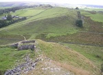
Visit Milecastle 45 Walltown (Hadrian's Wall), Walltown Crags, England (UNESCO site)
Milecastle 45 (Walltown) was a milecastle on Hadrian's Wall (grid reference NY67716657). Milecastle 45 is located on the top of Walltown Crags. The walls have been comprehensively robbed, and little remains but the robber trenches and turf-covered spoil mounds. The site is clearly visible as earthworks on aerial photographs. Each milecastle on Hadrian's Wall had two a... -
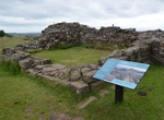
Visit Milecastle 48, Britannia, England
Milecastle 48 (Poltross Burn), is a milecastle on Hadrian's Wall (grid reference NY6340666195). Its remains lie near the village of Gilsland in Cumbria where it was historically known as "The King's Stables", owing to the well-preserved interior walls. Unusually a substantial section of stone stairs has survived within the milecastle. The two turrets associated with t... -
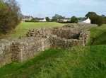
See Milecastle 49, Britannia, England
Milecastle 49 (Harrows Scar) was a milecastle on Hadrian's Wall (grid reference NY6202866407). Milecastle 49 is situated immediately west of the gorge of the River Irthing where the Wall was carried over the river by the bridge at Willowford. The scar or cliff and hence the milecastle are named after an ancient tenement called The Harrows which stood nearby. The tenem... -
Visit Milecastle 7 Benwell Bank (Hadrian's Wall), England (UNESCO site)
Milecastle 7 (Benwell Bank or Benwell Hill) was a milecastle of the Roman Hadrian's Wall. The milecastle itself has not been discovered by archaeologists and its presumed location lies beneath a modern housing development. Roman finds have been made in the area and the associated structure of Turret 7B is a significant surviving structure of the wall. Milecastle 7 has... -
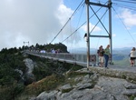
Walk across Mile-High Swinging Bridge, Grandfather Mountain, North Carolina
The attraction side of the mountain, which includes the Mile High Swinging Bridge, is accessed via Grandfather Mountain Entrance Road. The bridge is still the highest suspended footbridge in the world at 5,280 feet above sea level, its creaky swaying over dizzying heights an adrenaline rush for those brave enough to make the crossing. Admittance fees are charged at th... -
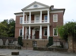
See Miles Brewton House, Charleston, South Carolina
The Miles Brewton House is a National Historic Landmark residential complex located in Charleston, South Carolina. It is one of the finest examples of a double house (a reference to the arrangement of four main rooms per floor, separated by a central stair hall) in Charleston, designed on principles articulated by Andrea Palladio. Located on two acres, its extensive ... -
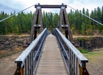
Cross Miles Canyon Suspension Bridge (Lowe Suspension Bridge), Whitehorse, Yukon, Canada
Miles Canyon Suspension Bridge (Lowe Suspension Bridge) was constructed in 1923 over the Miles Canyon of the Yukon River just south of Whitehorse, Yukon. -
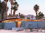
Stay at Miles C. Bates House (Desert Wave House), Palm Desert, California
Known as the Miles C. Bates “Wave" House for its curving roof that mimics the nearby San Jacinto mountains, the mid-century Walter S. White-designed home. Built in 1955 and meticulously restored by Stayner Architects. It was opened to the public in February 2020 for the first time since its restoration. Listed in the National Register of Historic Places, a one-... -
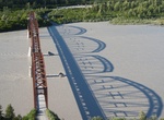
Cross Miles Glacier Bridge (Million Dollar Bridge), Alaska
The Miles Glacier Bridge, also known as the Million Dollar Bridge, was built in the early 1900s across the Copper River fifty miles from Cordova in what is now the U.S. state of Alaska. It is a multiple-span Pennsylvania truss bridge which completed a 196-mile (315 km) railroad line for the Copper River and Northwestern Railway, built by J. P. Morgan and the Guggenhei...
Price: $918.22