Give us feedback!


 See all

Our philosophy is simple. We want to encourage you to dream. BIG! Then we help you plan your trip, get the most out of it while you're traveling and help you share your experience with friends.
Join Now It's FREE
Dream Packages
Duration: 5 hours
Price: $106.33
Price: $106.33
Duration: 8 hours
Price: $220.83
Price: $220.83
Duration: 3 hours
Price: $180.00
Price: $180.00
Duration: 7 hours
Price: $179.00
Price: $179.00
Dreams Still To Do
Checked-Off Dreams
Dreams Still To Do
Checked-Off Dreams
Advertisement
Explore Adventure Sports
-
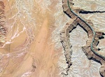
Hike Rider Canyon, Grand Canyon National Park, Arizona
Rider Canyon feeds into Marble Canyon on the Colorado River in Arizona. It's scenic canyon with narrows and potholes and has some steep scrambling to get in and out of the canyon. The hike is 5.5 miles rountrip and take 4-5 hours. Ropes are not required for the hike but there are some semi-technical climbs and scrambles to make it to the river. To get there drive... -
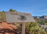
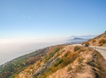
Mountain Bike Ridge Trail, Sedona, Arizona
Despite humble beginnings, this slightly obscure trail offers a breathtaking vantage of Cathedral Rock and Oak Creek Canyon. Along the way, expect shifts in scenery unparalleled by trails of comparable length. The Ridge Trail is a steep climb that culminates in a transcendent view into Red Rock Crossing and back towards Thunder Mountain. Advanced riders may cross the ... -
Stroll Riegelmann Boardwalk (Coney Island Boardwalk), Coney Island, New York City, New York
The Riegelmann Boardwalk (also known as the Coney Island Boardwalk) is a 2.7-mile-long (4.3 km) boardwalk along the southern shore of the Coney Island peninsula in the New York City borough of Brooklyn, facing the Atlantic Ocean. Opened in 1923, the boardwalk runs between West 37th Street at the edge of the Sea Gate neighborhood to the west and Brighton 15th Street in... -
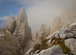
Hike to Rifugio Torre Di Pisa, Italian Dolomites
Take the 2-3 hour hike to the Torre di Pisa hut in the Italian Dolomites. It's the only mountain refuge in the Latemar group and is perched on Cavignon peak at 2671 Meters a.s.l. The sight you can enjoy from there is really incomparable. Near the hut you can see a 20-meter-high leaning pinnacle which looks like the famous leaning tower of the cathedral of Pisa. I... -
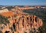
Hike Riggs Spring Loop Trail, Bryce Canyon National Park, Utah
The Riggs Spring Fire Trail, also known as the Riggs Spring Loop Trail, was built in Bryce Canyon National Park in 1936 to provide access to the park's backcountry for fire suppression crews. The approximately 8-mile (13 km) trail is significant for its association with Civilian Conservation Corps labor from CCC Camp NP-3, and represents the last link in the series of... -
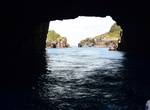
Explore RikoRiko Cave, Poor Knights Islands, New Zealand
Explore Rikoriko Cave in New Zealand, the world's largest sea cave. The cave is located in Maroro Bay on the north west side of Aorangi Island in the Poor Knights Islands. The cave is 130 metres long, a depth below water of 26 metres, and a height to the ceiling above water of 35 metres, and a width of 80 metres. Rikoriko Cave means dancing light, from the shimmering... -
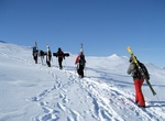
Ski or Snowboard Riksgränsen, Sweden
Riksgränsen,The National Borderin Swedish, is a ski-resort in Kiruna Municipality, Lappland, Sweden, 200 km north of the Arctic Circle. The skiing season is from February to June. From end of May the lifts operate under the midnight sun. Riksgränsen is a popular location for the winter testing of pre-production cars by various European manufacturers. Photo-s... -
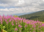
Hike Rila Mountains, Sofia, Bulgaria
Rila is the highest mountain range of Bulgaria and the Balkan Peninsula. It is situated in southwestern Bulgaria and forms part of the Rila–Rhodope Massif. The highest summit is Musala at an altitude of 2,925 m which makes Rila the sixth highest mountain range in Europe after the Caucasus, the Alps, Sierra Nevada, the Pyrenees and Mount Etna, and the highest one... -
Off-road to Riley's & Geer Camps, Mojave National Preserve, California
Riley's Camp and Geer Camp are nestled in the foothills of the Ivanpah Mountains in Mojave National Preserve. They have buildings, some being preserved and restored. Riley was a World War I veteran who came to the Mojave desert in the 1920s. He put his explosive skills to work mining the Ivanpah Mountains. By the time he died, he had placed 56 claims. Bembry erected t... -
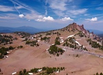
Drive Rim Drive, Crater Lake National Park
Rim Drive is a scenic highway in Crater Lake National Park in southern Oregon. It is a 33-mile (53 km) loop that follows the caldera rim around Crater Lake. Because of the its unique engineering and the surrounding park landscape, the drive was listed as a historic district on the National Register of Historic Places in 2008. Rim Drive is located high in the Cascade M... -
Drive Rim of the World Highway (SR 18), San Bernardino, California
State Route 18 (SR 18) is a state highway in the U.S. state of California. It serves as a primary route into the San Bernardino Mountains, both from the Riverside–San Bernardino metropolitan area from the south and the Mojave Desert from the north. SR 18 runs from State Route 210 in San Bernardino to State Route 138 in Llano. It has two discontinuities: one in B... -
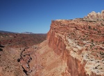
Hike Rim Overlook & Navajo Knobs Trails, Capitol Reef National Park, Utah
Rim Overlook & Navajo Knobs Trails are located within Capitol Reef National Park, Utah. The Strenuous 2.3 mi (3.6 km) Rim Overlook Trail has an elevation gain of 1,110 ft (338 m) and provides panoramas of Fruita and Waterpocket Fold from atop dramatic cliff. The 4.7 mi (7.6 km) Navajo Knobs Trail (1,620 ft (494 m)) is a continuation of Rim Overlook Trail, 360-degr... -
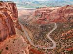
Drive Rim Rock Drive, Colorado National Monument
Rim Rock Drive is a scenic road in Colorado National Monument. The 23-mile drive follows the upper rim of a series of canyons, extending from the vicinity of Fruita, Colorado in the west to near Grand Junction, Colorado in the east, connecting points only eight miles apart in a straight line. The entire road has been designated a historic district on the National Regi... -
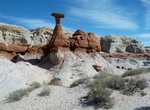
Hike to Rimrock Hoodoos, Utah
Rimrock Hoodoos are a wonderful and easily accessed cove contains darker versions as well as magnificent pearly white columns of the Wahweap Hoodoos. From Big Water, drive 12 miles west on Highway 89. Look for a small parking area and trailhead kiosk on the right side (north) of the road. -
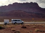
Ride Rim-to-Rim Shuttle, Grand Canyon National Park, Arizona
Ride the Trans-Canyon Shuttle Daily scheduled shuttle service between the North and South rims. Transit time is approximately 4.5 hours one way. Available during the North Rim's "full service" season (May 15 through October 15). Also available for hikers after the lodge closes (October 16 through November 30). Reservations required. 928-638-2820. Transcanyon Shuttle o...


Price: $606.00