Give us feedback!


 See all

Our philosophy is simple. We want to encourage you to dream. BIG! Then we help you plan your trip, get the most out of it while you're traveling and help you share your experience with friends.
Join Now It's FREE
Dream Packages
Duration: 2 days
Price: $469.00
Price: $469.00
Duration: 7 hours
Price: $179.00
Price: $179.00
Duration: 3 hours
Price: $173.83
Price: $173.83
Duration: 3 hours
Price: $180.00
Price: $180.00
Dreams Still To Do
Checked-Off Dreams
Dreams Still To Do
Checked-Off Dreams
Advertisement
Explore Adventure Sports
-
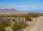
Off-road River Road, Big Bend National Park, Texas
River Road traverses the southern portion of the park, roughly connecting the areas near Rio Grande Village and Castolon. While generally following the course of the Rio Grande, the road runs a considerable distance from the river, especially in its mid-section near Mariscal Mountain. You cannot actually see the river along the River Road unless you take a side trip t... -
Cruise the River Seine, Paris, France (UNESCO site)
The River Seine stretches 776 kilometers from Source Seine, near the town of Dijon, in northeastern France to the English Channel at La Havre after bisecting Paris geographically as well as culturally near the middle of its route. The Right Bank (La Rive Droite) of the River Seine has historically been associated with an elevated level of sophistication and elegance i... -
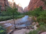
Hike Riverside Walk (Gateway to the Narrows Trail), Zion National Park, Utah
The Gateway to the Narrows Trail, also known as the Riverside Walk, is a relatively short nature trail of one mile along the Virgin River. It connects the parking area at the Temple of Sinawava with The Narrows and is listed on the National Register of Historic Places. The trail uses local materials such as red sandstone to blend with its surroundings, following the t... -
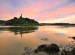
Fly Fish at River Slaney, Bunclody, Ireland
With its beginning at Lugnaquilla Mountain in the western Wicklow Mountains of southeast Ireland, the River Slaney traverses 117 kilometers of scenic Irish countryside before discharging into the Irish Sea at St. George’s Channel at the town of Wexford. Near the town of Bunclody in County Wexford the confluence of the River Slaney is seen with the River Clody. S... -
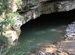
Take River Styx Cave Tour, Mammoth Cave National Park, Kentucky
Trace the stages of cave development from solid layers of limestone into the world’s longest known cave system. Follow the course of the water from ridge top to river bottom and witness the persistence and power required to create this geologic marvel. Experience some of the largest continuous canyon passages on the planet, smooth elliptical tubes and beautifull... -
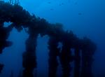
Wreck Dive River Taw Shipwreck, St Kitts
The 144 ft River Taw sunk in 1981 and is located just offshore of Frigate Bay in St Kitts. It was an island cargo ship that split in two durng Hurricame Hugo (1989), The two sections are now 50 feet apart in depths of 25-40 feet. The wreck sits on a sandy bottom surrounded by sea grass and rubble from construction of Port Zante. All of the decks and superstructure is ... -
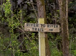
Hike River to River Trail, Illinois
The River to River Trail is a 160 mile (256 km)-long hiking trail that serves Shawnee National Forest in far southern Illinois. The trail is used by both equestrians and hikers. About half is on off road trails. Its eastern terminus has historically been Battery Rock, overlooking the Ohio River but now generally Elizabethtown, Illinois is used as the eastern terminus.... -
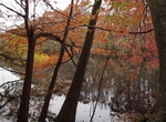
Hike River Trail, Congaree National Park, South Carolina
The River Trail in Congaree National Park, South Carolina is 10.4 miles (16.7 km) and takes 5.6 hours to complete. This trail takes you to the Congaree River, the lifeblood of the area's great natural diversity. About ten times a year, floodwaters from the river cover the park. Because much of the forest along the River Trail was logged prior to the park's establishme... -
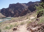
Hike River Trail, Grand Canyon National Park, Arizona
The River Trail is a 2 mile hiking trail in Grand Canyon National Park, located in the U.S. state of Arizona. Though it has no official trailhead, the River Trail is an important link in the trail system in Grand Canyon. This trail connects the Bright Angel Trail at its western terminus with Phantom Ranchand the Bright Angel Campground via the silver suspension b... -
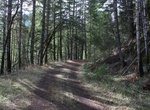
Mountain Bike Riverview Trail (Umpqua), Oregon
The original North Umpqua Highway was built in 1926. Today this route is a six-mile side trail (#1530) that offers hikers and mountain bikers a loop opportunity when combined with the Mott Segment of the North Umpqua Trail and Highway 138. Access to the trail is either from Bogus Creek Campground on the west end or just off Highway 138 on Forest Road 38 on the east en... -
Explore Riviera Nayarita, Nuevo Vallarta, Mexico
The Riviera Nayarit is a nearly 200-mile stretch of coastline between the historic port of San Blas in the Mexican state of Nayarit to where the Río Ameca empties into Banderas Bay, in Nuevo Vallarta. It includes such notable sites as Chacala Bay, Chacalilla, the archaeological zone of the Alta Vista, Aticama, Bucerías, Sayulita famous for surfing, San F... -
Wreck Dive RMS Rhone, British Virgin Islands
The was a British packet ship owned by the Royal Mail Steam Packet Company. She was wrecked off the coast of Salt Island in the British Virgin Islands on 29 October 1867 during a hurricane with the loss of approximately 123 lives. The Rhone is now a leading Caribbean wreck dive site and regarded by some as one of the best in world. Her bow section is still relatively ... -
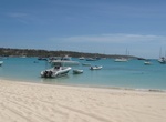
Relax on Road Bay Beach, Anguilla
Spend a relaxing afternoon on Anguilla's Road Bay Beach. The beaches found throughout Anguilla are usually fairly quiet, but at Road Bay is can get a little crowded - It's the perfect beach if you like vibrant atmospheres. Road Bay is a great anchorages for boaters. Though it has no moorings, there is plenty of room to swing at anchor and the bottom has good holding.... -
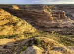
Hike Road Canyon, Cedar Mesa, Bears Ears National Monument, Utah
NOTE: A permit to hike or backpack is required. Road Canyon is accessed from the Cigarette Springs Road on Cedar Mesa. The elevation in the upper ends of Road Canyon begins at approximately 6,200 feet and drops to 4,900 feet at the lower ends. The walls of the canyon vary from 100 feet in the upper ends to over 500 feet in the lower ends. Erosion of the colorful Ceda... -
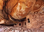
Hike Road Canyon to Fallen Roof Ruin, Cedar Mesa, Utah
Fallen Roof Ruin is located along Road Canyon in Cedar Mesa part of Bears Ears National Monument. It's a 3.0 miles (round trip) to the ruins. Hiking another 4.5 miles down the canyon will arrive at Seven Kivas Ruins. From the Kane Gulch Ranger Station, drive 9.0 miles south on State Route 261 to the Cigarette Springs Road. Turn east and drive 3.5 miles to an unma...


Price: $176.03