Give us feedback!


 See all

Our philosophy is simple. We want to encourage you to dream. BIG! Then we help you plan your trip, get the most out of it while you're traveling and help you share your experience with friends.
Join Now It's FREE
Dream Packages
Duration: 3 hours 30 minutes
Price: $99.36
Price: $99.36
Duration: 8 hours
Price: $83.37
Price: $83.37
Duration: 3 hours
Price: $173.83
Price: $173.83
Duration: 4 hours
Price: $120.43
Price: $120.43
Dreams Still To Do
Checked-Off Dreams
Dreams Still To Do
Checked-Off Dreams
Advertisement
Explore Adventure Sports
-
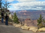
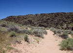
Hike Rim Trail, Grand Canyon National Park, Arizona
The Rim Trail is a hiking trail located on the South Rim of the Grand Canyon National Park, located in the U.S. state of Arizona. It is a 0,.9 trail between the South Kaibab Trailhead west to Hermit's Rest. Any section of the Rim Trail you will find jaw-dropping looks into the Grand Canyon, but the unpaved section between Maricopa Point and Hermits Rest is a dirt... -
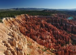
Hike Rim Trail, Bryce Canyon National Park, Utah
The Rim Trail offers hikers the opportunity to see Bryce from on top. The entire Rim Trail extending from Fairyland to Bryce Point has several steep elevation changes and is 5.5 miles/9.16 kilometers one way. -
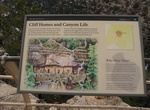
Hike Rim Trail (Walnut Canyon), Arizona
Stroll along the canyon rim through a mixed juniper and pinion pine forest. Two canyon overlooks provide scenic views of the canyon and cliff dwellings below. Explore a partially rebuilt pithouse and pueblo set back from the canyon rim. On a summers day, visit the demonstration garden that features traditional crops grown by the Sinagua. Do your part to protect the p... -
Hike or Mountain Bike Rimutaka Rail Trail, New Zealand
The Rimutaka Rail Trail is a walking and cycling track in the North Island of New Zealand. It runs between Maymorn and Cross Creek, and follows 22 kilometres (14 mi) of the original route of the Wairarapa Line over the Rimutaka Ranges between the Mangaroa Valley and the Wairarapa, including the world-famous Rimutaka Incline. Parts of the trail are also used by vehicle... -
Hike Rinconada Canyon Trail, Petroglyph National Monument, New Mexico
The longest petroglyph viewing trail system in Petroglyph National Monument, this moderate undeveloped trail is 2.2 miles round-trip. Water is not available. Vault restroom facility is available at the trail head. See approximately 300 petroglyphs in 1.5-2 hours. Leashed pets allowed. Parking lot is open 8:00 am to 5:00 pm daily. A free trail guide is available at th... -
Surf Rincón Beaches, Puerto Rico
The winter surf along Puerto Rico's northwest coast is considered one of the best surf spots across the globe. Rincón is home to many of the best surfing beaches in Puerto Rico. The 1968 World Surfing Championship was held at Domes Beach in Rincon. Since then, surfers from around the world have been visiting Rincon in search of the perfect wave. Rincon is well... -
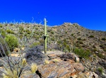
Hike Rincon Mountains Trails, Saguaro National Park, Arizona
The Rincon Mountains are a significant mountain range east of Tucson, Pima County, Arizona, in the United States. The Rincon Mountains are one of five mountain ranges surrounding the Tucson valley. The other ranges include the most prominent, the Santa Catalina Mountains to the north, the Santa Rita Mountains to the south, the Tucson Mountains to the west, and the Tor... -
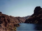
Dive Ringbolt Rapids, Lake Mohave, Arizona
A deep depression at the base of rapids, Ringbolt Rapids is for technically advanced divers only. Visibility at the rapids is only fair due to turbulence and bubbles. A hand-held buddy line and surface support boat are essential. Dive safely! Location: Lake Mohave, Arizona side near Sunken Work Barge Depth: 50-70 feet TIPS: Advanced Divers Only AVOID THE NE... -
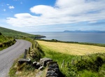
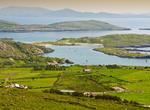
Drive Ring of Beara, Ireland
The "Ring of Beara" is a tourist trail for cars which follows the roads for about 148 kilometres (92 mi) circumnavigating the peninsula. It starts in Kenmare, crossing the Healy Pass through Adrigole, passing Castletownbere, Allihies, and turn offs to Dursey Island, Eyeries and Ardgroom, ending in Glengarriff. The area has had a long connection with the sea; Castletow... -
Drive Ring of Kerry, Ireland
The Ring of Kerry is a tourist route in County Kerry, south-western Ireland. The route covers the 179 km circular road (N70, N71 and R562), starting from Killarney, heading around the Iveragh Peninsula and passing through Kenmare, Sneem, Waterville, Cahersiveen and Killorglin. Popular points include Muckross House (near Killarney), Staigue stone fort and Derrynane Hou... -
Drive or Bike Ring Road (Route 1), Iceland
Route 1 or the Ring Road is a national road in Iceland that runs around the island and connects most of the inhabited parts of the country. The total length of the road is 1,332 kilometres (828 mi). Some of the most popular tourist attractions in Iceland, such as the waterfalls Seljalandsfoss and Skógafoss, and Jökulsárlón glacier lagoon, are... -
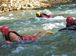
Raft, River Board or Tube Rio Bueno, Jamaica
Take a short walk through the beautiful Jamaican rainforest as you make your way to the launching spot. Then, hop in the water on your river board and navigate through the winding Rio Bueno to the Caribbean Sea. -
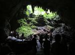
Explore Río Camuy Caves, Puerto Rico
The Parque de las Cavernas del Río Camuy (Camuy River Cave Park), is one of the largest cave systems in the world and the largest in the Western Hemisphere. It is located between the municipalities of Camuy, Hatillo and Lares in northwestern Puerto Rico, but the main entrance to the park is located in Quebrada, Camuy. The caverns are part of a large network of ... -
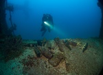
Wreck Dive Rio de Janeiro Maru, Chuuk Lagoon, Micronesia
The Rio de Janeiro Maru was a 142 metre-long freighter. At the time of the attack, she was anchored east of Uman Island and suffered hits by 1000lb bombs, probably from aircraft launched from the Yorktown and Bunker Hill. She sank at 00:30 on the 18th February 1944 and came to rest on her starboard side at a depth of ~35 metres. The shallowest point is at ~23 metres.... -
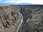
Explore Rio Grande Gorge, New Mexico
The Rio Grande Gorge runs from northwest to southeast of Taos, New Mexico, through the basalt flows of the Taos Plateau volcanic field. The gorge depth is 800 feet just south of the Gorge Bridge, which spans the gorge ten miles northwest of Taos. The gorge has white water rapids and many ancient petroglyphs. At the bottom of the gorge, the Rio Grande is flanked by hi...


Price: $179.00