Give us feedback!


 See all

Our philosophy is simple. We want to encourage you to dream. BIG! Then we help you plan your trip, get the most out of it while you're traveling and help you share your experience with friends.
Join Now It's FREE
Dream Packages
Duration: 7 hours
Price: $179.00
Price: $179.00
Duration: 4 hours
Price: $120.43
Price: $120.43
Duration: 2 days
Price: $469.00
Price: $469.00
Duration: 3 hours
Price: $140.24
Price: $140.24
Dreams Still To Do
Checked-Off Dreams
Dreams Still To Do
Checked-Off Dreams
Advertisement
Explore Adventure Sports
-
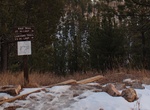
Hike Canyons Trail, Jewel Cave National Monument, South Dakota
This trail is rough and uneven due to the washouts that occur during heavy rains, please be prepared for this if you hike the trail. Please check at the visitor center to see if trail is open. The trail begins at the covered patio outside the Jewel Cave National Monument visitor center lobby and winds its' way down into Lithograph Canyon. Turning right at a fence th... -
Hike Canyon View Trail, Navajo National Monument, Arizona
Canyon View Trail offers a view of head of Betatakin Canyon. It leads leads from the visitor center to campground (0.6-mile round trip). -
Hike Canyon X, Arizona
Canyon X is a slot canyon just a few feet wide but more than 100 feet deep near Lake Powell in northern Arizona. This canyon has a lot of the same gorgeous features as nearby Antelope Canyon but without the crowds. It is on Navajo land that is privately run and is fenced off. Visits to Canyon X require a Navajo Reservation permit and are limited to four people at a t... -
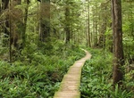
Hike Cape Alava Trail, Olympic National Park, Washington
Cape Alava Trail is 3.3 miles one way partly on boardwalk from near the ranger station to the coast. A 2.9 mile beach walk connects with Sand Point Trail to the south making a 9.0 mile loop. Cape Alava, in Clallam County, Washington, U.S., is the westernmost point in the contiguous 48 states (during low tide and walking out to the west side of Tskawahyah Island). The ... -
Ride Cape Argus Pick 'n Pay Cycle Tour, Cape Town, South Africa
The Cape Argus Pick 'n Pay Cycle Tour (referred to in short as the Argus) is an annual cycle race hosted in Cape Town, South Africa, usually 109 km long. It is the first event outside Europe to be included in the International Cycling Union's Golden Bike Series. South Africa hosts some of the largest, by number of entrants, sporting events in the world with three bein... -
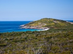
Explore Cape Arid National Park, Western Australia
Cape Arid National Park is a national park in Western Australia (Australia), 731 kilometres (454 mi) south-east of Perth. The park is situated 120 kilometres (75 mi) east of Esperance and lies on shore from the eastern end of the Recherche Archipelago. The bay at its western end isDuke of Orleans Bay, and the bay at the eastern side is Israelite Bay. Its coastline is ... -
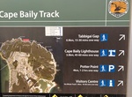
Hike Cape Baily Track, Botany Bay National Park, New South Wales, Australia
Cape Baily Coast Walk is a 5.5 km, grade 3 hike located in the Botany Bay National Park, New South Wales. Cape Baily Lighthouse is a scenic stop along track in the Kurnell area of Kamay Botany Bay National Park, near Cape Solander. -
Drive Cape Borda Road, Kangaroo Island, South Australia
Cape Borda Lighthouse (formerly known as the Flinders Light) is a lighthouse in the Australian state of South Australia located at Cape Borda on Kangaroo Island. Located on the north western corner of Kangaroo Island, this unique square lighthouse was built in 1858 and is steeped in European history. The road can be rough a... -
Hike to Cape Brett Lighthouse (Cape Brett Track), New Zealand
Cape Brett Lighthouse is a lighthouse at Cape Brett in the Northland Region of the North Island of New Zealand. The site was surveyed and chosen in 1908 by Captain John Bollons of NZGSS Hinemoa. The lighthouse was deactivated and keepers withdrawn in 1978 and replaced by an automated beacon on the same site. -
Hike Cape Buffon Walk, Canunda National Park, South Australia
Cape Buffon Walk is a 2.5 km loop hike in Canunda National Park. -
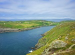
Explore Cape Clear Island, Ireland
Clear Island or Cape Clear Island (officially known by its Irish name: Cléire, and sometimes also called Oileán Chléire) lies south-west of County Cork in Ireland. It is the southernmost inhabited part of the island of Ireland and has a population of over 100 people. Officially it is a Gaeltacht (Irish-speaking area), and most inhabitants speak Ir... -
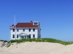
Explore Cape Cod National Seashore, Massachusetts
The Cape Cod National Seashore (CCNS) encompasses 43,500 acres (176 km2) on Cape Cod, Massachusetts. It includes ponds, woods and beachfront of the Atlantic coastal pine barrens ecoregion. The CCNS includes nearly 40 miles (64 km) of seashore along the Atlantic-facing eastern edge of Cape Cod, in the towns of Provincetown, Truro, Wellfleet, Eastham, Orleans and Chatha... -
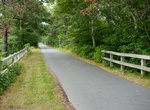
Bike Cape Cod Rail Trail, Harwich, Massachusetts
The Cape Cod Rail Trail (CCRT) is a 25.5-mile (41.0 km) paved rail trail located on Cape Cod in Massachusetts. The trail route passes through the towns of Yarmouth, Dennis, Harwich, Brewster, Orleans, Eastham, and Wellfleet. It connects to the 6-plus mile (10 km) Old Colony Rail Trail leading to Chatham, the 2 mile Yarmouth multi-use trail, and 8 miles (13 km) of trai... -
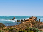
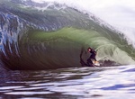
Surf Cape Fear, NSW
Cape Fear is a local Sydney break on the southern side of Botany Bay at Cape Solander. Known locally as 'Ours', it became the site of a Red Bull big wave surfing competition in August 2014 called Red Bull Cape Fear. -
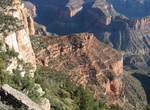
Hike Cape Final Trail, Grand Canyon National Park, Arizona
Cape Final Trail is a 4.0 mile (6.4 km) round-trip hiking trail along the North Rim of Grand Canyon National Park. It takes approximately 2 hours round-trip hiking time and has an elevation gain of 210 ft (64 m). Cape Final is at an elevation of 7,916 feet (2,413 m) and overlooks the eastern Grand Canyon from Nankoweap to the Unkar Creek Delta. It also shows how ...


Price: $242.00