Give us feedback!


 See all

Our philosophy is simple. We want to encourage you to dream. BIG! Then we help you plan your trip, get the most out of it while you're traveling and help you share your experience with friends.
Join Now It's FREE
Dream Packages
Duration: 2 days
Price: $469.00
Price: $469.00
Duration: 7 hours
Price: $179.00
Price: $179.00
Duration: 2 days
Price: $242.00
Price: $242.00
Duration: 7 hours
Price: $144.00
Price: $144.00
Dreams Still To Do
Checked-Off Dreams
Dreams Still To Do
Checked-Off Dreams
Advertisement
Explore Adventure Sports
-
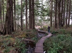
Hike Cape Flattery Trail, Washington
The Cape Flattery Light is a historic lighthouse structure located at the entrance to the Strait of Juan de Fuca near Neah Bay, Clallam County, in the U.S. state of Washington. The deactivated lighthouse sits on Tatoosh Island, which is named after Chief Tatooche of the Makah Tribe. It is the northwesternmost lighthouse on the West Coast of the contiguous United State... -
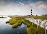
Explore Cape Hatteras National Seashore, North Carolina
Cape Hatteras National Seashore preserves the portion of the Outer Banks of North Carolina from Bodie Island to Ocracoke Island, stretching over 70 miles (110 km). Included within this section of barrier islands along N.C. 12, but outside the National Seashore boundaries, are Pea Island National Wildlife Refuge and several communities, such as Rodanthe, Buxton, and Oc... -
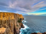
Hike Cape Hauy Track, Tasman National Park, Tasmania
The Cape Hauy Track (4-5 hours round trip) starts from Fortescue Bay, just near the boat ramp. The walk passes through a variety of heath and woodland to the magnificent views of steep cliffs and spectacular rock formations. -
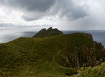
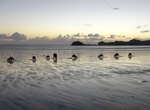
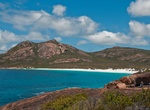
Explore Cape Hillsborough National Park, Queensland, Australia
Cape Hillsborough is a national park in Queensland, Australia, 837 km northwest of Brisbane. The park is a peninsula of volcanic origin, covered largely by rainforest; the maximum elevation is 267 m. The main hike in the park is 9 km (4 hrs) from Beachcombers Cove Beach to Casuarina Beach. Make sure to check tide tables before leaving on a hike through the park since ... -
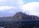
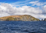
Sail by Cape Horn, Chile
Cape Horn is the southernmost headland of the Tierra del Fuego archipelago of southern Chile, and is located on the small Hornos Island. Although not the most southerly point of South America, (which are the Diego Ramírez Islands) Cape Horn marks the northern boundary of the Drake Passage; for many years it was a major milestone on the clipper route, by which s... -
Visit Cape Horn, Chile
Scale the cliff stairs and walk the boardwalk paths of Cape Horn, the southernmost and closest point to Antarctica. Cape Horn is the southernmost headland of the Tierra del Fuego archipelago of southern Chile, and is located on the small Hornos Island. Although not the most southerly point of South America, (which are the Diego Ramírez Islands) Cape Horn marks ... -
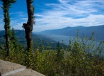
Hike Cape Horn Loop Trail, Washington
This 8 mile loop trail will bring you to a great viewpoint over the Columbia at about 1,200 feet then drop you down to the very edge of the river along fields of lava rocks and by basalt towers. You'll pass a waterfall on the way to the Cape Horn Road that will bring you back to the parking lot as well. -
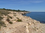
Hike Cape Kamenjak, Croatia
Cape Kamenjak is a small peninsula consisting of more than 30 km of coastline with several coves and beaches. -
Explore Cape Kiwanda State Natural Area, Oregon
Cape Kiwanda State Natural Area is located in Pacific City, Oregon. Hiking to the top of Cape Kiwanda allows views of Nestucca Bay to the south and Cape Lookout to the north. A sea stack, named Haystack Rock is located 0.5 miles (0.8 km) south west of the cape. It is one of three features along the Oregon coast that bear the name. Probably, the best known is the one ... -
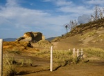
Hike Cape Le Grand Coastline Trail, Western Australia
The Cape Le Grand National Park Coastline Trail in Western Australia is a 15km long hiking trail follows the coastline from Le Grand beach, passing through Hellfire Bay, Thistle Cove, Lucky Bay and ending at Rossiter Bay. The trail is well signposted and information boards along the way point out the significant flora, fauna and cultural features. Most people take 6-8... -
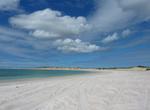
Visit Cape Leveque Beaches, Western Australia
Cape Leveque is the northernmost tip of the Dampier Peninsula in the Kimberley region of Western Australia. The Cape's sandy beaches are attracting an increasing number of visitors. Cape Leveque was a camping ground for ancient nomadic people of Northern Australia and probably is still being used today. Their huge middens over shadow the small caravan park resting on ... -
Visit Cape Lookout State Park, Oregon
Cape Lookout is a sharp rocky promontory along the Pacific Ocean coast of northwestern Oregon in the United States. It is located in southwestern Tillamook County, approximately 10 mi (16 km) southwest of Tillamook, just south of Netarts Bay. The promontory extends 1 mi (1.6 km) perpendicular to the coast, and is approximately 0.25 mi (0.5 km) wide at its base, taperi... -
Hike Cape Pillar Track to The Blade, Tasman National Park, Tasmania, Australia
The Blade in Tasman National Park, Tasmania, is a dramatic hiking spot known for its towering cliffs and stunning views of the Southern Ocean. It's located in the Cape Pillar region, offering varied trails suitable for different skill levels. The Blade itself is a knife-edge of rock that provides a unique perspective on the surrounding area, including Tasman Island. -
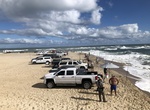
Fish at Cape Point, Hatteras Island, North Carolina
Cape Point is the easternmost beach of Hatteras Island, meaning it stretches out into the ocean further than any other beach in the Outer Banks. It's anexcellent fishing spot. -
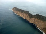
Hike Cape Raoul Track, Tasmania, Australia
Cape Raoul is situated at the southern-most part of the Tasman Peninsula, in south eastern Tasmania. It forms the coastline of Raoul Bay, and is part of the Dolerite landscape of the Tasman National Park. So named from D'Entrecasteaux's pilot. Flinders called it Basaltic Cape, but only prior to the publication of the maps of the French expedition. "In 1814 Flinders ve...

Price: $140.24