Give us feedback!


 See all

Our philosophy is simple. We want to encourage you to dream. BIG! Then we help you plan your trip, get the most out of it while you're traveling and help you share your experience with friends.
Join Now It's FREE
Dream Packages
Duration: 3 hours 30 minutes
Price: $99.36
Price: $99.36
Duration: 4 hours 30 minutes
Price: $176.03
Price: $176.03
Duration: 3 hours
Price: $173.83
Price: $173.83
Duration: 3 hours
Price: $140.24
Price: $140.24
Dreams Still To Do
Checked-Off Dreams
Dreams Still To Do
Checked-Off Dreams
Advertisement
Explore Adventure Sports
-
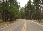
Drive Cape Royal Road, Grand Canyon National Park, Arizona
Cape Royal on the North Rim provides a panorama up, down, and across the canyon. With seemingly unlimited vistas to the east and west, it is popular for both sunrise and sunset. The sweeping turn of the Colorado River at Unkar Delta is framed through the natural arch of Angels Window. Look for the Desert View Watchtower across the canyon on the South Rim. This popular... -
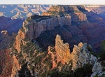
Hike Cape Royal Trail, Grand Canyon National Park, Arizona
The Cape Royal Trail is a 1 mile (1.6 km) round trip hiking trail on the North Rim of the Grand Canyon National Park. Cape Royal on the North Rim offers a 270 degree panorama views up, down, and across the canyon. This popular viewpoint is accessible via a paved, level trail. With seemingly unlimited vistas to the east and west, it is popular for both sunrise and... -
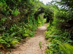
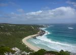
Hike Cape Sebastian Trail, Cape Sebastian State Scenic Corridor, Oregon
Cape Sebastian Trail (3.3-mile (5.3 km)) goes through a forest with ocean views to reach an isolated beach. If you're lucky, the trail will give you a chance to enjoy awe-inspiring views of the gray whales on their bi-annual migrations. -
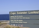
Drive Cape Solander Drive, Kurnell, New South Wales, Australia
Head to one of Sydney's best whale watching spots. Cape Solander, located in the Kurnell section of Kamay Botany Bay National Park is an unbeatable lookout during whale watching season. If you're driving into the Kurnell area of Kamay Botany Bay National Park please note that gates are open: 7am-7.30pm (August to May) 7am-5.30pm (June to July) -
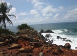
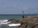
Surf Cape Three Points, Ghana
Cape Three Points (French:Cap Trois Points) is a small peninsula in the Western Region of Ghana on the Atlantic Ocean. Cape Three Points is a six-hour drive from Accra, with the last 40 minutes of the journey along a rough track that can become difficult to navigate during the rainy season. Forming the southernmost tip of Ghana, Cape Three Points is located between th... -
Hike Cape to Cape Track, Western Australia
The Cape to Cape Walk Track is a long-distance walk trail located in the far south-west corner of Western Australia, 250 km south of Perth. It meanders along the whole length of the Leeuwin-Naturaliste Ridge, which forms the backbone of the Leeuwin-Naturaliste National Park. Its start and finish are the lighthouses at the tips of Cape Naturaliste and Cape Leeuwin. The... -
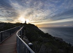
Hike Cape Tourville Lighthouse, Freycinet National Park, Tasmania
The Cape Tourville Lighthouse is an unmanned, automatic lighthouse built in 1971 by private contractors (Hurburgh and Olbrich). The road was constructed through virgin eucalypt forest, along with the powerline, with minimal disruption to the National Park. The top of the granite headland was levelled by blasting to provide the base for the lighthouse and parking area.... -
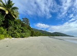
Explore Cape Tribulation, Daintree National Park, Queensland, Australia
Cape Tribulation is a headland located within the Daintree National Park. From the mid 1980's the first backpackers hostels started getting built, and in the 1990s some more resorts for the more upmarket tourists. Nowadays there are also several small owner operated Bed and Breakfast eco lodges hidden away in the rainforest. Compared to a lot of famous tourist de... -
Hike Cape Wrath Trail, Scottish Highlands, Scotland
Cape Wrath Trail is a hiking route that runs through the Scottish Highlands and along the west coast of Scotland. It is approximately 200 miles (321 km) in length and is considered to be one of the most challenging long distance walks in the UK. Despite not being an officially recognised National Trail it has grown to be one of the most highly regarded backpacking rou... -
Explore Cape York Peninsula, Queensland, Australia
Cape York Peninsula is a large remote peninsula located in Far North Queensland at the tip of the state of Queensland, Australia, the largest unspoiled wilderness in northern Australia and one of the last remaining wilderness areas on Earth. Although the land is mostly flat and about half of the area is used for grazing cattle, and wildlife is threatened by introduced... -
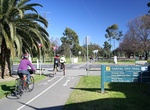
Stroll or Bike the Capital City Trail, Melbourne, Victoria
The Capital City Trail is a shared use path for cyclists and pedestrians, which circles the Melbourne city centre and some inner eastern and northern suburbs of Melbourne, Victoria, Australia. It is 29km in length, and mostly consists of sections of other trails, such as the Merri Creek Trail, Main Yarra Trail, Moonee Ponds Creek Trail and Inner Circle Rail Trail. A p... -
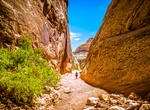
Hike Capitol Gorge Pioneer Trail, Capitol Reef National Park, Utah
Capitol Gorge is a canyon within Capitol Reef National Park in Utah. Capitol Gorge becomes deep and narrow, with several sections of almost slot-like proportions. The gorge was the main route through the park until Highway 24 was built in 1964. The 2 mile round trip hike has Petroglyphs, a pioneer register, and the famous water tanks. This hike follows the gorge for ... -
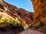
Drive Capitol Gorge Road, Capitol Reef National Park, Utah
The Capitol Gorge Road dirt road is located in the southern part of Capitol Reef National Park. The Capitol Gorge spur road was a through road from 1884 to 1962, the drive now ends in a few miles. From there you get out and hike the rest of the way through the Gorge. On this hike you see historic inscriptions from pioneers of the 19th and 20th century who traveled alo... -
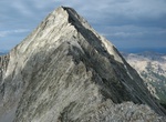
Summit Capitol Peak, Elk Mountains, Colorado
Capitol Peak is a high and prominent mountain summit in the Elk Mountains range of the Rocky Mountains of North America. It is the 52nd highest mountain in North America. The 14,137-foot (4,309 m) fourteener is located in the Maroon Bells-Snowmass Wilderness of White River National Forest, 8.7 miles (14.0 km) east by south (bearing 104°) of the community of Redsto... -
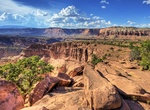
Explore Capitol Reef National Park, Utah
Capitol Reef National Park is located in south-central Utah. It is 100 miles (160 km) long but fairly narrow. The park, established in 1971, preserves 378 mi² (979 km²) and is open all year, although May through September are the most popular months. Called "Wayne Wonderland" in the 1920s by local boosters Ephraim P. Pectol and Joseph S. Hickman, Capitol Ree...

Price: $180.00