Give us feedback!

Our philosophy is simple. We want to encourage you to dream. BIG! Then we help you plan your trip, get the most out of it while you're traveling and help you share your experience with friends.
Join Now It's FREE
Related Categories
Dreams Still To Do
Checked-Off Dreams
Dreams Still To Do
Checked-Off Dreams
Advertisement
Explore Viewpoints
-
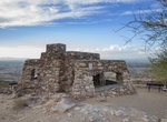
Visit Dobbins Lookout, South Mountain Park, Phoenix, Arizona
Dobbins Lookout is the highest point accessible by trail in South Mountain Park at 2,330 feet (710 meters). Accessible by hiking or driving. -
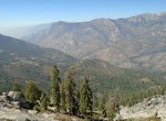
Hike Don Cecil Trail to Lookout Peak, Kings Canyon National Park, California
The Don Cecil Trail climbs the relatively cool north-facing slope of the canyon. This historic trail was the major access route to Cedar Grove prior to the completion of Highway 180 in 1939. Beyond Sheep Creek, the climb to Lookout Peak provides an incredible panorama of the park's backcountry. This strenuous, all-day hike is 13 miles round trip and climbs some 4000... -
Visit Donnell Vista, Stanislaus National Forest, California
A ¼ mile paved trail with signs along the way, leads to an overlook with sweeping views of the Middle Fork Stanislaus River Canyon, and Donnell Reservoir.We invite everyone to visit this newly improved majestic overlook. Located on Highway 108 about 18 miles east of Pinecrest. -
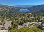
Cross Donner Lake Overlook, Truckee, California
Donner Lake Overlook is a great place to stop for a photo of Donner Lake. -
Explore Double Peak Park (San Marcos), California
Double Peak is located south of San Marcos, California. The elevation at the summit is 1,646 ft (502 m), and approximately 1,000 feet (305 m) above the north foot of the mountain. Most trails leading to the summit of Double Peak are classified as "moderately strenuous." It offers one of the best panoramic views in North County San Diego. It is a great place for sunset... -
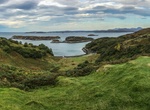
Visit Drumbeg Viewpoint, Sutherland, Scotland
Great viewpoint of islands and seals. -
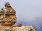
Visit Duck On A Rock Viewpoint, Grand Canyon National Park, Arizona
Duck On A Rock Viewpoint is located along Desert View Drive in Grand Canyon National Park, Arizona. -
Visit Eagle Gorge Lookout, Kalbarri National Park, Western Australia
Gain stunning views from the Eagle Gorge Lookout or wander down to a delightful beach in the tranquil depths of the gorge. Visitors can access Eagle Gorge lookout and beach via walk tracks from the carpark. The trailhead for the Birgurda Trail also begins at Eagle Gorge. Avid hikers can take in the entire coastal cliff area on the this 8km trail. -
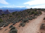
Hike East Rim Trail (Dead Horse Point), Dead Horse Point State Park, Utah
This trail begins at the visitor center and travels along the eastern side of the mesa top to Dead Horse Point, providing a fun hiking alternate to simply driving the main park road. The East Rim offers great views towards the La Sal Mountains and Behind the Rocks area as well as sagebrush flats and juniper forest. Aside from a short hill a quarter mile from the visit... -
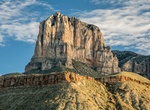
See El Capitan, Guadalupe Mountains National Park, Texas
El Capitan is the southern-most point of the Guadalupe Mountains. At 8,085 feet above sea level, El Capitan is the eighth highest peak in Texas and it's imposing height and stark outline have made it an iconic image for generations of travelers. It is considered the "signature peak" of West Texas.No formal trail reaches the summit. Hikers can scramble up to the summit... -
Hike Elephant Rock, Ko Samui, Thailand
There's a gigantic rock formation called Elephant Rock between Chaweng and Lamai Beach on Ko Samui. Locals named it after the size of the real life elephant. It's possible to climb or hike the rock and it's totally worth it as the view from the top is amazing. -
See Elephant Rock from Miradouro das Pedras Negras
Miradouro das Pedras Negras (Viewpoint of Black Stones), Azores, Sao Miguel, Portugal. -
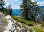
Visit Eleven Range Overlook, Sequoia National Park, California
On clear days, views from Eleven Range Overlook can extend to California's Coast Range on the opposite side of the San Joaquin Valley. -
Hike Elk Flats Trail, Oswald West State Park, Arch Cape, Oregon
The Elk Flats trail will take you to the swirling waters of Devil's Caldron, and to the top of a cliff peering over the waves. Easy hike to 2 beautiful cliff faces riddled with sea caves and views of the ocean. -
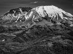
Visit Elk Rock Viewpoint, Spirit Lake Hwy, Washington
The Elk Rock Viewpoint is off Spirit Lake Hwy (State Route 504) and serves as the entrance to the Mount St. Helens National Volcanic Monument.