Give us feedback!

Our philosophy is simple. We want to encourage you to dream. BIG! Then we help you plan your trip, get the most out of it while you're traveling and help you share your experience with friends.
Join Now It's FREE
Related Categories
Dreams Still To Do
Checked-Off Dreams
Dreams Still To Do
Checked-Off Dreams
Advertisement
Explore Viewpoints
-
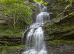
See Cathedral Falls, Gauley Bridge, West Virginia
Cathedral Falls is a beautiful 60+ foot waterfall on Cane Branch. It cascades down a narrow canyon and lands right beside US Rt 60. -
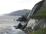
Visit Ceann Sléibhe, Dingle Peninsula, Ireland
Ceann Sléibhe is a nice viewpoint along Slea Head Drive. -
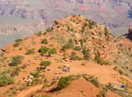
Hike to Cedar Ridge (South Kaibab Trail), Grand Canyon National Park, Arizona
The hike from South Kaibab Trailhead to Cedar Ridge has a 1,140 feet (347 m) elevation drop and is 1.5 miles (2.4 km) one-way. Stop at Ooh-Aah Point along the way. The trailhead is located at end of Yaki Point Road. Allow 3-4 hours to do the hike. Check out the ranger guided hikes to Cedar Ridge on the South Kaibab Trail. Offered daily during the summer. The hike... -
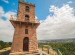
Visit Centenary Tower, Mount Gambier, South Australia
1904 tower at the summit of Mt Gambier offering views over the volcanic, lake-dotted countryside. -
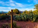
Hike to Centennial Trail Viewpoint, Sedona, Arizona
A short, easy, paved hike to a 270° view of the mountains surrounding Sedona and the basin to Red Rock Country. Trailhead at Girdner/Cultural Park Trailhead. Great spot for sunsets. -
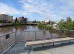
Visit Chena River Viewpoint at William Ransom Wood Centennial Bridge, Fairbanks, Alaska
Crossing the Chena River in Fairbanks, Alaska, on the William Ransom Wood Centennial Bridge, a pedestrian bridge. -
Visit Cheongsapo Daritdol Observatory, Haeundae District, Busan, South Korea
Cheongsapo Daritdol Observatory is an elevated walkway in Haeundae District, Busan, South Korea. The walkway has transparent floors, and is meant to offer visitors a view of the reefs underneath the path, as well as of the nearby coast of Cheongsapo and of the sea. There is a small circular plaza at the center point of the walkway that is equipped with LED lights. It ... -
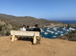
Hike or Bike Cherry Cover Overlook, Santa Catalina Island, California
This is a nice easy hike from Two Harbors along the flat road to the West End. About 2.25 miles round trip. -
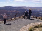
Visit Chessman Ridge Overlook, Cedar Breaks National Monument, Utah
Overlooking Chessmen Ridge, this overlook is centrally located on the rim overlooking the Cedar Breaks Amphitheater. It is the highest elevation overlook in the park at 10,461ft and offers stunning views of the ridge and surrounding formations. The overlook features one of the larger parking lots and can be used to access a bristlecone pine grove and the Alpine Pond L... -
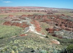
Visit Chinde Point Overlook And Picnic Area, Petrified Forest National Park, Arizona
Chinde Point Overlook and Picnic Area is at the located at the end of a short spur road off Petrified Forest Road. It has covered picnic areas, water, and restrooms. The point is one of eight Painted Desert Overlooks in Petrified Forest National Park. -
Visit Civita Park Tunnel, San Diego
Civita Park Tunnel goes under a road to a viewpoint overlooking Mission Valley. The tunnel has a nice mural. Civita Park slopes down the former quarry property in a series of mesas that provide residents with defined areas to exercise, relax, gather, or play. The park is connected by finger trails to adjoining neighborhoods. Vista points offer visitors panoramic... -
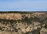
Visit Cliff Canyon Overlook, Mesa Verde National Park, Colorado
Cliff Canyon Overlook and Cliff Palace Loop Road are open 8 am to sunset from late spring to December 1, or until the first significant snowfall.The Cliff Canyon Overlook opens up to a stunning view of Cliff Canyon. In the 1200s, Cliff Canyon was a thriving neighborhood, where Ancestral Pueblo people went about their daily lives.With careful observation, vis... -
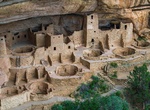
Visit Cliff Palace Overlook, Mesa Verde National Park, Colorado
With at least 150 rooms and 21 kivas, Cliff Palace is an exceptionally large cliff dwelling. It was surrounded by a vibrant, active community. Because of the large kiva to room ratio, some scholars suggest Cliff Palace was an important gathering place, perhaps an administrative center with ceremonial use for many Ancestral Pueblo villages. The people who lived in the ... -
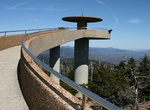
Hike to Clingmans Dome, Great Smoky Mountains National Park
Clingmans Dome (or Clingman's Dome) is a mountain in the Great Smoky Mountains of Tennessee and North Carolina, in the southeastern United States. Clingmans Dome is protected as part of the Great Smoky Mountains National Park. At an elevation of 6,643 feet (2,025 m), it is the highest mountain in the Smokies, the highest point in the state of Tennessee, and the highes... -
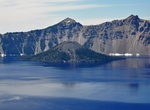
Visit Cloudcap Overlook, Crater Lake National Park
The highest viewpoint on Rim Drive offers spectacular views both inside and outside the Mazama caldera. A short side road leads to the viewpoint. This view is looking north with Cleetwood Cove at the left, the Wineglass at the rim center of the photo, Mount Thielsen at the right.