Give us feedback!


 See all

Our philosophy is simple. We want to encourage you to dream. BIG! Then we help you plan your trip, get the most out of it while you're traveling and help you share your experience with friends.
Join Now It's FREE
Dream Packages
Duration: 8 hours
Price: $246.07
Price: $246.07
Duration: 3 days
Price: $499.72
Price: $499.72
Duration: 8 days
Price: $1251.74
Price: $1251.74
Dreams Still To Do
Checked-Off Dreams
Dreams Still To Do
Checked-Off Dreams
Advertisement
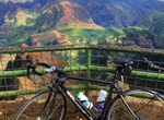
Explore Cycling
-
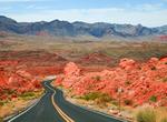
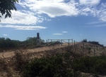
Drive Valley of Fire Hwy, Nevada
Valley of Fire Highway is the main road through Valley of Fire State Park, offering miles of stunning and vibrantly colored scenery. For the best views, branch off to White Domes Road, a 5.7-mile road with access to petroglyphs, hiking trails and views. Or check out the 3-mile circuit, Scenic Loop Road, which also branches from Valley of Fire Highway and will take you... -
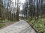
Hike or Ride Vejle Valley, Denmark
Vejle Valley offers some of Denmark’s most scenic and rugged woodland valleys. Vejle Fjord is a fjord in Denmark. It is approximately 22 km (13.7 mi) in length, and stretches east from the town of Vejle at the head to the towns of Trelde Naes on the south side and Juelsminde on the north side at the mouth. The fjord's generally calm surface waters are surrounde... -
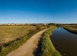
Cycle Via Ecologica Ciclavel, Aveiro, Portugal
Via Ecologica Ciclavel is a 48km long cycling path broken between Estarreja - Albergaria-a-Velha - Aveiro (23 km) and Vagos - Mira (25 km). The route leads mostly along the river and among natural surroundings. -
Attend Vuelta a España, Spain
The Vuelta a España (Tour of Spain) is an annual multiple stage bicycle race primarily held in Spain, while also occasionally making passes through nearby countries. Inspired by the success of the Giro d'Italia and the Tour de France, the race was first organized in 1935. The race was prevented from being run by the World Wars and the Spanish Civil War in the e... -
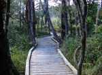
Hike or Mountain Bike Waikato River Trails, New Zealand
The Waikato River Trails is a combined walk- and cycleway along the Waikato River. In 2009 the trails became one of the seven Quick Start Projects that form the beginning of the New Zealand Cycle Trail. The trail is proposed to be 100 km long, out of which 50 km existed before the NZCT scheme was created. In mid-2011, work on the last sections of the cycle trail proje... -
Hike or Mountain Bike Wai Koa Trail, Kauai, Hawaii
The 5 mile Wai Koa Trail on Kauai is a great hiking or mountain biking trail through gardens, mahogany forest, citrus grove, tranquil lagoons and a secluded swimming hole. The trailhead is now located at the dog park off Kuhio Highway (Hwy 56). -
Cycle down Waimea Canyon (State Road 550), Kauai, Hawaii
Start your adventure in Waimea Canyon Lookout at 3,600 feet, and cruise downhill with frequent stops to check out Waimea Valley’s various sights. Go down 12 miles (19km) on smooth winding blacktop all the way to the shore of the blue Pacific. It's 100% downhill, and 100% fun! -
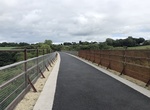
Hike or Bike Waterford Greenway, Ireland
The Waterford Greenway, also known locally as the Déise Greenway, is a route on a former railway track in County Waterford, Ireland, used for cycling and hiking. It opened in March 2017, on what was originally the Mallow/Waterford railway line, and forms part of EuroVelo 1 route. The Waterford Greenway features 11 bridges, three viaducts and a 400-metre tunnel ... -
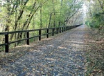
Hike or Bike Western Maryland Rail Trail, Maryland
The Western Maryland Rail Trail (WMRT) is a 22.5-mile (36.2 km) long shared-use asphalt-paved rail trail from Fort Frederick to Pearre Station, Maryland, United States, that is suitable for walkers, joggers, bikers, rollerbladers and, weather permitting, cross country skiing and snowshoeing. The trail runs on the abandoned right-of-way of the Western Maryland Railroad... -
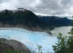
Hike or Ride West Glacier Trail (Mendenhall Glacier), Alaska
The West Glacier Trail is 3.5 miles long. It begins at end of Skater's Cabin Road and ends at the junction of the Mt. McGinnis Route. The West Glacier trailhead cannot be reached from the Mendenhall Glacier Visitor Center. The trail begins on the north side of the parking lot. Most of this walk is below the glacier trimline amid many willow, cottonwood, and alder tre... -
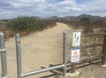
Hike or Ride West Sycamore 16 Trail, Mission Trails Regional Park, California
Hike, mountain bike or equestian West Sycamore 16 Trail. The trailhead is located just outside the gate to West Sycamore Staging Area in Mission Trails Regional Park. It's heads south for 0.35 miles and then forks into two 0.25 mile brands that both end at Marine Corps Air Station (MCAS) Miramar. -
Hike or Ride West Sycamore North Trail, Mission Trails Regional Park, California
Hike, mountain bike or equestian West Sycamore North Trail. The trailhead is located at the northern end of West Sycamore Staging Area in Mission Trails Regional Park. It's heads north for 0.3 miles and then forks into 3 short branches. The northern branch connects with the trail connecting Beeler Canyon Rd and Goodan Ranch Staging Area. -
Hike or Ride West Sycamore South Trail, Mission Trails Regional Park, California
Hike, mountain bike or equestian West Sycamore South Trail. The trailhead is located at the southern end of West Sycamore Staging Area in Mission Trails Regional Park. It's heads south for 0.78 miles and end at Marine Corps Air Station (MCAS) Miramar. There is a branch at mile 0.43 that heads east fo 0.35 miles. -
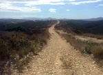
Mountain Bike White Ridge Bike Trails, Ojito Wilderness, New Mexico
Tucked away in rugged and scenic country southwest of the community of San Ysidro, New Mexico, is the White Ridge Bike Trails Area. Just to the west is the newly designated Ojito Wilderness. Both sites are a short distance from U.S. 550. This region is known for its geological, cultural and paleontological resources, as well as for its scenic qualities. The bike trail... -
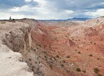
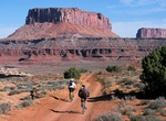
Off-road or Mountain Bike White Rim Road, Canyonlands National Park
The 100-mile White Rim Road loops in Canyonlands National Park in Utah usually take two to three days by four-wheel-drive vehicle or three to four days by mountain bike. When the weather is good the road is considered moderately difficult for high-clearance, four-wheel-drive vehicles. The steep, exposed sections of the Shafer Trail, Lathrop Canyon Road, Murphy's Hogb...


Price: $571.07