Give us feedback!


 See all

Our philosophy is simple. We want to encourage you to dream. BIG! Then we help you plan your trip, get the most out of it while you're traveling and help you share your experience with friends.
Join Now It's FREE
Dream Packages
Duration: 15 hours
Price: $571.07
Price: $571.07
Duration: 3 days
Price: $499.72
Price: $499.72
Duration: 8 hours
Price: $246.07
Price: $246.07
Dreams Still To Do
Checked-Off Dreams
Dreams Still To Do
Checked-Off Dreams
Advertisement
Explore Cycling
-
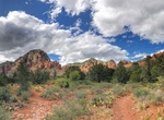
Hike or Mountain Bike Teacup Trail, Sedona, Arizona
The best place to view this Teacup Rock is from the short and scenic Teacup Trail, which crosses the Soldier Pass area before traversing the base of Coffee Pot Rock. -
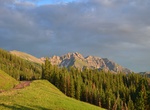
Mountain Bike Telluride Ski Resort, Colorado
Telluride is surrounded by an extensive network of single track bike trails and old mining roads great for every skill level from beginners to the most advanced riders. Push the limits on one of Telluride’s classic single track trails, or take a scenic ride on Telluride’s valley floor alongside the San Miguel River. Telluride is the perfect place to rent a... -
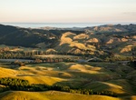
Hike or Mountain Bike Te Mata Peak, New Zealand
Te Mata Peak is a peak south of Hastings rising up to 399m in the Hawke's Bay region of New Zealand. A sealed road leads to the popular lookout at the summit, as well as several trails for hikers and mountain bikers. The Hastings suburb of Havelock North is built on the slopes of the peak. As the highest peak in the area, it offers views over the Heretaunga Plains, an... -
Hike or Bike to Tennessee Beach, Marin Headlands, California
Tennessee Valley is an amazing offshoot of the Marin Headlands, with hiking trails to suit the whole family. The Tennessee Valley Trail is mostly level; it begins at the parking area and travels 1.7 miles to Tennessee Beach. For the more adventurous hiker, there are a number of other trails leading into the hills above Tennessee Valley. In the spring, the vegetation ... -
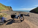
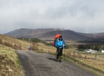
Bike or Hike The Badger Divide, Scotland
The Badger Divide (The Badger) is a 210-mile route that winds, climbs, dips and slaloms through the Scottish Highlands from Inverness to Glasgow. It passes through some of Scotland's greatest natural landmarks including lochs (including Ness and Laggan), glens, moorland, forests and the 25-mile Corrieyairack mountain pass. The surfaces include 80.3 miles of paved and... -
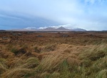
Drive or Cycle The Bog Road (Roundstone Bog), Connemara, Ireland
Driving or Cycling The Bog Road through Roundstone Bog in Connemara, County Galway offers tranquil scenery with the backdrop of the Twelve Bens. Take the R341 towards Ballyconneely, turn left at Ballinaboy before the bridge and you will discover the famous Roundstone Bog conservation area. -
Cycle The Heron Trail, London, UK
The Heron Trail is 15+1⁄2-mile (24.9 km) long cycling trail that links with National Cycle Route 1 between Higham and Strood, then it heads around the Hoo Peninsula via Regional route 18 (now renamed National Cycle Route 179 ) passing through 'Hoo St Werburgh', 'High Halstow' and 'Cliffe' before returning to Higham. It has a mixture of rural and maritime interes... -
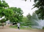
Go on The Lady Bird Lake Hike and Bike Trails, Austin, Texas
The Lady Bird Lake Hike and Bike Trail, formerly the Town Lake Hike and Bike Trail, creates a complete circuit around Lady Bird Lake. It is one of the oldest urban Texas hike and bike paths. The trail is the longest trail designed for non-motorized traffic maintained by the City of Austin Parks and Recreation Department and watched after by a local non-profit named Th... -
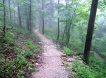
Hike or Ride The Mammoth Cave Railroad Bike & Hike Trail, Kentucky
The Mammoth Cave Railroad Bike and Hike Trail is a 9 miles trail that follows an old railroad corridor around Mammoth Cave National Park, Kentucky. The exact route of the Mammoth Cave Railroad could not be completely duplicated due to the development of state and park roads since the railroad's closure. Your route today will require crossing these roads at several pla... -
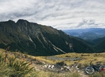
Hike or Mountain Bike The Old Ghost Road, New Zealand
The 85 km Old Ghost Road is located on the west coast of the South Island of New Zealand. It goes from Seddonville to Lyell (Upper Buller Gorge) and takes 2-4 days to complete. This old gold miners’ road has been revived as a mountain biking and trekking trail. The advance trail is 85 km one way and take 4 - 5 days (hiking) or 2 - 3 days (mounting biking). -
Hike or Bike The Old Ingraham Highway, Everglades National Park, Florida
The Old Ingraham Highway opened in 1922 as the first motorway to Flamingo. A new highway opened in the 1960s and now the road is used for biking and hiking. The road is up to 22 miles long. -
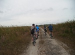
Hike or Mounatin Bike The Queenstown Trail, New Zealand
The Queenstown Trail or Queenstown Trail is a cycle and walking trail funded as one of the projects of the New Zealand Cycle Trail (NZCT) system in Otago, New Zealand. It links the towns of Queenstown, Arrowtown and the area of Gibbston. It is 110 km in length but is not linear and instead follows the terrain and rivers to link key places in a series of tracks that al... -
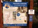
Bike or Hike The Tahoe-Pyramid Trail, Nevada
The Tahoe-Pyramid Trail is based on a vision for a trail that would follow the entire length of the Truckee River, from its source at forested Lake Tahoe (6225′) to the desert terminus of Pyramid Lake (3796′). The current route can be traveled by foot or by bicycle, and when fully completed, will descend over 2000 feet during the entire course of the 114-m... -
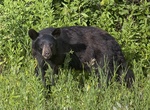
Hike or Mountain Bike Tilson Lake Loop, Riding Mountain National Park, Manitoba, Canada
The Tilson Lake Loop is a multipurpose trail located in the western portion of the park, as that side side of the park is not as heavily forested as the eastern side, and provides views over open meadows and rolling hills for hikers, horseback riders and bikers. Take advantage of the diverse photographic and wildlife viewing opportunities along this trail. Don't forg... -
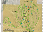
Mountain Bike or Hike Tilted Mesa, Kanab, Utah
The Tilted Mesa trail system consists of three connected mesas. From west to east, these are called First, Second, and Third Mesa. Tilted Mesa is interconnected and in total consists of approximately 13 miles of single-track trail designed specifically for mountain biking, and is located approximately 9.5 miles east of Kanab, Utah. The 400-acre trail system is situa...

Price: $1251.74