Give us feedback!


 See all

Our philosophy is simple. We want to encourage you to dream. BIG! Then we help you plan your trip, get the most out of it while you're traveling and help you share your experience with friends.
Join Now It's FREE
Dream Packages
Duration: 3 days
Price: $499.72
Price: $499.72
Duration: 15 hours
Price: $571.07
Price: $571.07
Duration: 8 hours
Price: $246.07
Price: $246.07
Dreams Still To Do
Checked-Off Dreams
Dreams Still To Do
Checked-Off Dreams
Advertisement
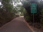
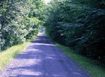
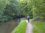
Explore Cycling
-
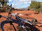
Hike or Mounatin Bike Slim Shady Trail, Sedona, Arizona
Slim Shady is great trail for hilers and Intermediate to advanced rider, nothing too big to overcome and the views are unreal. Park at the southern Bell Rock Trailhead off highway 179. Sedona Is the New Mountain Bike Mecca. One of the best things about Sedona is the variety of rides and how close they are to town - the trails are all close enough to town to ride to. T... -
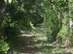
Hike or Ride Snake Bight Trail, Everglades National Park, Florida
The 1.6 miles (2.6 km) one way Snake Bight Trail near Flamingo. Walk through a tropical hardwood hammock with dozens of tropical tree species. There's great bird watching on the boardwalk at the end of the trail if you plan to arrive near high tide. Bikes are allowed except on the boardwalk at the end of the trail. It's located 4 miles (6 km) north of the Flamingo V... -
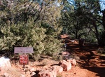
Hike or Ride Soldier Pass Trail, Sedona, Arizona
Soldier Pass Trail wanders through some of Sedona's most iconic red rock country. The trail offers fantastic views of Coffee Pot Rock and surrounding rock formations and cliffs, and passes by Devil's Kitchen, the area's largest natural sinkhole. The trail ascends Brins Mesa, joining Brins Mesa Trail, providing opportunities for longer hikes and loop hikes in the exten... -
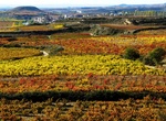
Cycle through Spain's Rioja Vineyards
Take a bike tour through Spain's Rioja Vineyards. Every hue of orange, green and brown as far as the eye can see is the main attraction for those bike tourists that cycle through the Rioja Vineyards between Logroño and Haro in Spain at just the right time of year. The recommendation is to plan this 35 mile (56 km) tour in the northern hemisphere’s fall (i... -
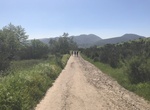
Hike Spring Canyon, California
The hike up Spring Canyon starts at the East Fortuna Staging Area. It's about 0.7 miles to the Route 52 bridge. At this point the trail leaves Mission Trails park. At mile 0.95 the road forks. Take the left fork up the little and then turn right to following the trail up the canyon. There is a single track just before this turn or continue up the initial road to mile... -
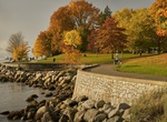
Walk or Ride Stanley Park Seawall Path, Vancouver, Canada
The 10-km or 13,123-step seawall loop around Stanley Park is Vancouver’s most popular fresh-air attraction. The seawall in Vancouver, British Columbia, Canada is a stone wall that was constructed around the perimeter of Stanley Park to prevent the erosion of the park's foreshore. Colloquially, the term also denotes the pedestrian, bicycle, and rollerblading path... -
Ride State Route 56 Bike Path, San Diego, California
The State Route 56 Bike Path in San Diego is free of cars and connects inland and coastal San Diego County. The route gradually inclines traveling inland, so starting at the west and go uphill for the first half, then the second half is all down hill. The path parallels State Route 56 closely for much of the way. Parking is available on the western end of the tra... -
Hike or Ride St John Valley Heritage Trail, Maine
The St. John Valley Trail takes riders 16.5 miles from Fort Kent through St. John to St. Francis. Riders tour the countryside to experience rolling hills, farmland and several miles along the edge of the St. John River. While the trail is located near highways, users get a sense of remoteness. The trail is open year round for multiple use. Enjoy the trail and please ... -
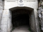
Hike or Mountain Bike Strada delle 52 Gallerie, Italy
The Strada delle 52 Gallerie (Road of 52 tunnels or Strada della Prima Armata – Road of the First Army) is a military mule road built during World War I on the massif Pasubio in Veneto, Italy. The road winds between Bocchetta Campiglia (1,216 m) and the Porte del Pasubio (1,934 m) crossing the southern slope of the mountain, outside of the range of Austro-Hungar... -
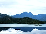
Cycle around Sun Moon Lake, Taiwan
Located in the heart of Taiwan, Sun Moon Lake has long been charming curious foreigners and local visitors alike. Cyclists can tour Around the Sun Moon Lake in Taichung, Taiwan experiencing the calm, turquoise water that has inspired many ancient Chinese poets and painters. The route around the largest lake in Taiwan is a three-hour ride, where visitors can enjoy lake... -
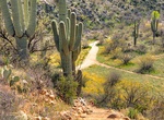
Hike or Ride Sutherland Trail, Catalina State Park, Arizona
Sutherland Trail is a 9.1 miles, one-way trail in Catalina State Park. No dogs in Desert Bighorn Sheep Management Area — no bikes in Wilderness Area The first few miles are easy hiking. Beginning at Trailhead parking lot, the trail gradually climbs 700 feet. Plan on 90 minutes of walking time from the Trailhead to park boundary. After 1-mile trail weaves in and... -
Hike or Ride Sycamore Canyon Road, Mission Trails Regional Park, California
Sycamore Canyon Trailhead is located at Goodan Ranch Staging Area in northern Mission Trails Regional Park. -
Hike or Ride Taff Trail, Wales
The Taff Trail is a popular walking and cycle path that runs for 55 miles (89 km) between Cardiff Bay and Brecon in Wales. It is named so because it follows the course of the River Taff. Along much of its length, it follows the National Cycle Network Route 8 (Lôn Las Cymru) that continues to Holyhead, and is substantially off-road. The trail makes much use of an... -
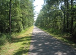
Hike or Ride Tammany Trace, Louisiana
The Tammany Trace is a rail trail in Louisiana occupying a former Illinois Central Railroad corridor. It has been developed into a 31-mile (50 km) asphalt trail for hiking, cycling, and wheelchair use with a parallel equestrian trail. It connects Covington, Abita Springs, Mandeville, Lacombe, and Slidell running along the northshore of Lake Pontchartrain. The trail wa... -
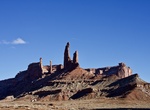
Off-road or Mountain Bike Taylor Canyon Road (White Rim Road), Canyonlands National Park, Utah
Taylor Canyon Road is accessed from White Rim Road (permit required) in Canyonlands National Park.
Price: $1251.74