Give us feedback!


 See all

Our philosophy is simple. We want to encourage you to dream. BIG! Then we help you plan your trip, get the most out of it while you're traveling and help you share your experience with friends.
Join Now It's FREE
Dream Packages
Duration: 3 days
Price: $499.72
Price: $499.72
Duration: 15 hours
Price: $571.07
Price: $571.07
Duration: 8 days
Price: $1251.74
Price: $1251.74
Dreams Still To Do
Checked-Off Dreams
Dreams Still To Do
Checked-Off Dreams
Advertisement
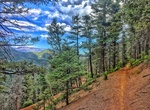
Explore Cycling
-
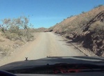
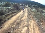
Off-road or Mountain Bike Callville Wash North Trail, Nevada
A fairly easy drive, Callville Wash North Trail gives you the thrill of driving in the wilderness without ever being more than 2 miles from the paved Northshore Road. Although in most conditions, it can probably done in a 2WD vehicle like a Jeep, 4WD is recommended for safety, as the second half of the drive gets rougher and rockier. Always check the weather report be... -
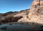
Off-road or Mountain Bike Callville Wash South Trail, Nevada
The Callville Wash South Road is a dirt road along the bed of Callville Wash, running from Northshore Road and featuring 5 miles of rugged desert landscape, including sandstone bluffs and imposing mountains. It is a fairly safe road that ends across the water from Callville Bay, but does have some sections where a 4WD is highly recommended. TIPS: Pay attention t... -
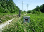
Hike or Bike Calumet Trail, Indiana Dunes National Park, Indiana
The trail follows the South Shore Railroad tracks and NIPSCO power lines. There is no shade. The trail can be impassible (i.e. wet shoes) due to standing water along much of the trail that can be 4-6" deep in spots. The trail is not suitable for road bikes.The Calumet Trail connects to many trail systems. The west trailhead parking lot connects to the Porter Brickyard... -
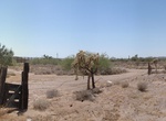
Drive or Mountain Bike Camino de Dos Republicas, Organ Pipe Cactus National Monument, Arizona
Camino de Dos Republicas to Gachado line-shack and Dos Lomitas ranch house goes for 10 miles off of Hwy 85. This road is rough and crosses several washes. Please read the caution signs at the beginning of this road. The Gachado Line Camp main house is a great example of vernacular architecture, which means that the house was entirely built using materials found natur... -
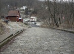
Go up Canton Avenue, Pittsburgh, Pennsylvania
Canton Avenue, in Pittsburgh, Pennsylvania's Beechview neighborhood, is the steepest officially recorded public street in the United States. Canton Avenue is 630 ft (190 m) long (the hill is about 65 meters long) and is claimed to include a 37 percent grade 21 ft (6.4 m) feet long. According to the Guinness Book of World Records, Baldwin Street, in Dunedin, New Zealan... -
Hike or Ride Canyon Loop Trail, Catalina State Park, Arizona
Canyon Loop Trail is an easy 2.3 miles, loop hike through the foothills that begins and ends at the Trailhead parking lot. The loop is created by a link connecting the Romero Canyon Trail and the Sutherland Trail. The trail is relatively flat, but about halfway around there is a slope with approximately 90 stairs. There is a bypass trail around the steps for horses. P... -
Ride Cape Argus Pick 'n Pay Cycle Tour, Cape Town, South Africa
The Cape Argus Pick 'n Pay Cycle Tour (referred to in short as the Argus) is an annual cycle race hosted in Cape Town, South Africa, usually 109 km long. It is the first event outside Europe to be included in the International Cycling Union's Golden Bike Series. South Africa hosts some of the largest, by number of entrants, sporting events in the world with three bein... -
Hike or Mountain Bike Captain Jacks Trail, Colorado
Captain Jacks Trail is a multi-use trail (hiking, mtb, horses, and moto's) located in North Cheyenne Cañon Park near Colorado Springs, Colorado. -
Hike or Ride Cardiac Hill Trail, Sycamore Canyon Reserve, California
The 1.31 miles Cardiac Hill Trail goes through Sycamore Canyon Reserve and Mission Trails Regional Park. The eatern trail head if just east of the Hwy 67 Staging Area. -
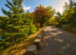
Hike or Ride Carriage Paths & Bridges, Acadia National Park, Maine
John D. Rockefeller Jr. gave the precursor to Acadia National Park much of its land. Like many rusticators, Rockefeller, whose family fortune was derived from the petroleum industry, wanted to keep the island free of automobiles; but local governments allowed the entry of automobiles on the island's roads. Rockefeller then constructed approximately 45 miles of ca... -
Hike or Ride Cassidy Trail, Red Canyon, Utah
Cassidy Trail #33093 begins at the Red Canyon Trailhead. This single track trail extends northerly to the ridge between Red Canyon and Losee Canyon; then northerly to the Casto Canyon Trail in Casto Canyon. The trail travels through spectacular red rock terrain and a variety of vegetation types including stands of old growth ponderosa pine. Special sites along the tra... -
Mountain Bike Cathedral Rock Big Loop, Sedona, Arizona
The 6.2-mile Cathedral Bike Loop takes riders out of Red Rock State Park via the east gate, down Verde Valley School Road, across Oak Creek (no bridge) and back to the park’s entrance on the Upper Loop Road. -
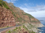
Drive or Cycle Chapman's Peak Drive, South Africa
Chapman's Peak is the name of a mountain on the western side of the Cape Peninsula, about 15 kilometres south of Cape Town, South Africa. It is opposite the inlet on which the town of Hout Bay is centred. The western flank of the mountain falls sharply for hundreds of metres into the Atlantic Ocean. A spectacular road, known as Chapman's Peak Drive, hugs the near-vert... -
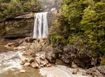
Hike or Mountain Bike Charming Creek Walkway to Mangatini Falls, New Zealand
Hike to Mangatini Falls along Charming Creek Walkway along the Ngakawau river near Ngakawau, New Zealand. Scenery and history combine as you walk on an old railway formation. The Charming Creek Walkway is 19 km out and back and takes about 6 hours to hike. Mountain bike is intermediate grade 3. There are two points of access to the walkway. The southern end is clear... -
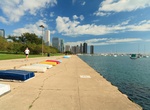
Hike or Bike Chicago Lakefront Trail, Chicago, Illinois
The Chicago Lakefront Trail (abbreviated as LFT) is a foreshoreway for walking and cycling, running 18-mile (29 km) along the coast of Lake Michigan in Chicago, Illinois. The path connects various beaches and recreational amenities located along the lakefront and also serves as a route for bicycle commuters. The trail is located wholly within the Chicago city limits a...


Price: $246.07