Give us feedback!


 See all

Our philosophy is simple. We want to encourage you to dream. BIG! Then we help you plan your trip, get the most out of it while you're traveling and help you share your experience with friends.
Join Now It's FREE
Dream Packages
Duration: 3 days
Price: $499.72
Price: $499.72
Duration: 8 days
Price: $1251.74
Price: $1251.74
Duration: 8 hours
Price: $246.07
Price: $246.07
Dreams Still To Do
Checked-Off Dreams
Dreams Still To Do
Checked-Off Dreams
Advertisement
Explore Cycling
-
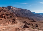
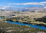
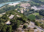
Off-road or Mountain Bike Chicken Corners Safari Trail & Kane Springs Road, Moab, Utah
Chicken Corners Safari Trail is a very popular ATV, UTV and dirt bike area near Moab, Utah. Descend the dramatic west side of Hurrah Pass to the Colorado River. Explore natural caves at Catacomb Rock. From Chicken Corners, look across river to see dramatic Thelma & Louise Point. Camp in designated sites only in Kane Creek Canyon. -
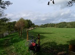
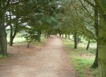
Hike or Ride Chief Ladiga Trail, Alabama
The Chief Ladiga Trail is a rail trail in Alabama. It is the state's first rail trail project. The 33-mile (53 km) trail stretches from the Alabama-Georgia state line to Weaver. The Chief Ladiga is on the same rail corridor as the Silver Comet Trail in Georgia as far as Piedmont, Alabama. From there it parallels an abandoned Southern Railway line for a few miles west ... -
Drive or Ride Chief Mountain Highway, US & Canada
The Chief Mountain Highway offers exhilarating vistas of the Waterton and Blakiston valleys. The Chief Mountain Highway is the primary route between Waterton Lakes National Park and Glacier National Park (U.S). The highway climbs from the grasslands near Maskinonge Lake to a viewpoint which offers a magnificent panorama of the Waterton and Blakiston valleys (Chief Mou... -
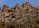
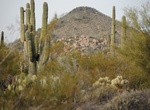
Hike or Ride Cholla Mountain Loop Trail, McDowell Sonoran Preserve, Arizona
The Cholla Mountain Loop Trail starts at the Borown's Ranch Trailhead. It rounds Cholla Mountain and returns, covering a boulder-and-saguaro-dotted landscape. Includes side trails to Balance Rock. -
Hike or Ride Clutha Gold Trail, Central Otago, New Zealand
The 73 km Clutha Gold Trail in Central Otago is one of the ‘Great Rides’ of the Nga Haerenga, New Zealand Cycle Trail, a truly unique heritage experience between Roxburgh and Lawrence. The trail starts at Lake Roxburgh Dam. Either hike or mountain bike the trail along rugged semi-arid dry lands through to lush green contoured farmlands. Almost two thi... -
Hike or Mountain Bike Clyde Walkway, Scotland
The Clyde Walkway is a foot and mountain bike path which runs from Glasgow, Scotland, to just above the UNESCO World Heritage village of New Lanark. The path runs close to the River Clyde for most of its length. It was completed in 2005. Glasgow to Cambuslang Bridge (9.5 miles/15 kilometres) – this section starts at Partick station (which is on a line from Glasg... -
Drive or Ride Col de Turini, France
The Col de Turini (el. 1607 m) is a high mountain pass in the Alps in the department of Alpes-Maritimes in France. It lies near Sospel, between the communes of Moulinet and La Bollène-Vésubie in the Arrondissement of Nice. It is famous for a stage of the Monte Carlo Rally which is held on the tight road with its many hairpin turns. Until a few years ago,... -
Ride or Drive up Col du Grand Colombier, Jura mountains, France
Col du Grand Colombier (el. 1,501 metres or 4,925 feet) is a mountain pass in the Jura mountains in France. This pass lies at the southern extremity of the Jura in the massif of the Grand Colombier. With the Col du Chasseral, it is the highest road pass in the Jura. It passes between the Grand Colombier (el. 1,531 m (5,023 ft)) and the Croix du Colombier (1,525 m (5,0... -
Hike or Ride Cone Mountain Loop Trail, McDowell Sonoran Preserve, Arizona
Cone Mountain Trail Loop is a 3.8 mile trail in McDowell Sonoran Preserve that starts at the Borown's Ranch Trailhead. Take upper ranch trail to the first intersect with Cone Mountain Loop. Go through a terrific rock garden on the north west side of Cone Mountain and right after that is a garden of Saguaro. -
Hike or Ride Corbiere Walk, Jersey (Channel Islands)
The Corbiere walk links St Aubin to La Corbiere on Jersey, and makes a very pleasant 4 mile linear walk. It follows an old railway line which closed in 1946. The path is very popular on the weekends, and has a mixture of families and cyclists. Half way along is the "On the tracks" Cafe. -
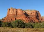
Hike or Mounatin Bike Courthouse Butte Loop Trail, Sedona, Arizona
The moderate 4.5 mile hike on Courthouse Butte Loop Trail provide great view of both Courthouse Butte and Red Rock. Courthouse Butteis a butte just north of the Village of Oak Creek, south of Sedona. Summit elevation is 5,440 feet (1,660 m). It is just east of Bell Rock. The eastern and northern sides are the most scenic, tranquil and upclose views of the trail. On t... -
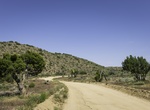
Off-road or Mountain Bike Covington Flats Road, Joshua Tree National Park, California
The dirt roads in the Upper Covington Flats has some of the park's largest Joshua Trees, junipers, and pinyon pines. The landscape is stark along most of Lower Covington Flat Road; the result of several lightning-strike wildfires during the the late 1990s. From Covington Flat picnic area to Eureka Peak is 3.8 miles (6.2 km) one way. The dirt road is steep near the end... -
Hike or Ride Cowichan Valley Trail, British Columbia, Canada
The Cowichan Valley Trail is a spectacular multi-use trail that is an integral part of The Great Trail (Trans Canada Trail) route on Southern Vancouver Island. The Cowichan Valley section runs from the Capital Regional District boundary at the top of the Malahat, north to Shawnigan Lake and the Kinsol Trestle, west to the Town of Lake Cowichan then north to the Nanaim... -
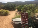
Hike or Mountain Bike Cowles via Big Rock Trail, San Diego, California
A less busy option for hiking up Cowles Mountain. -
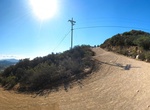
Hike or Mountain Bike Cowles via Mesa Trail (Service Rd), Santee, California
A less busy option for hiking up Cowles Mountain. This route you will also find a different variety in the landscape with a creek crossings, riparian plants, chaparral-shaded trails, and a meadow crossing.

Price: $571.07