Give us feedback!


 See all

Our philosophy is simple. We want to encourage you to dream. BIG! Then we help you plan your trip, get the most out of it while you're traveling and help you share your experience with friends.
Join Now It's FREE
Dream Packages
Duration: 3 days
Price: $499.72
Price: $499.72
Duration: 15 hours
Price: $571.07
Price: $571.07
Duration: 8 hours
Price: $246.07
Price: $246.07
Dreams Still To Do
Checked-Off Dreams
Dreams Still To Do
Checked-Off Dreams
Advertisement
Explore Cycling
-
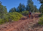
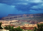
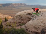
Off-road or Mountain Bike to Gemini Bridges, Moab, Utah
Gemini Bridges is an arch located on the rim of an arm of Bull Canyon along the Gemini Bridges 4x4 Road. From the center of Moab, travel north on Highway 191 for 9.8 miles. Turn left to cross a cattleguard near an old ore car by the railroad tracks, cross the tracks, and turn left to follow the southerly dirt road paralleling the tracks. (Non-licensed vehicles must s... -
Off-road or Mountain Bike Geology Tour & Berdoo Canyon Roads, Joshua Tree National Park, California
Geology Tour Road turns south from the paved road two miles (3.2 km) west of Jumbo Rocks Campground. It's 18 miles (29 km) round trip. It's 5 miles (8 km) one way to Paac Kü̱vü̱hü̱’k. 4-wheel drive is recommended; high clearance necessary beyond Paac Kü̱vü̱hü̱’k. The distance from the junction to Squaw Tank is 5.4 miles (8.8 k... -
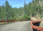
Hike or Mountain Bike George S. Mickelson Trail, South Dakota
The Mickelson Trail follows the abandoned Burlington Northern line that took trains from Edgemont, South Dakota up north to the Black Hills and the gold mines of the Deadwood area. At approximately 110 miles (176 km), cyclists will see a plethora of landscapes, ranging from distinctive granite rock formations to hay bale-dotted farmland. Among the highlights are stret... -
Hike or Mountain Bike Gibbs Hill Track, New Zealand
Hiking and mountain biking the Gibbs Hill Track in Abel Tasman National Park. There are two tracks: Wainui – Gibbs Hill – Totaranui – road back to Wainui: This 23 km track takes 2 1/2 (biking) or 5 hours (walking). If walking, a more pleasant option is to return to Wainui from Totaranui using the Abel Tasman Coast Track. For biking the circuit is... -
Ride Gila Circuit, New Mexico
This 83 mile paved bike loop path from Silver City, New Mexico runs through the pine-scented Pinos Altos Mountains. -
Mountain Bike or Hike Girdner Trail, Coconino National Forest, Arizona
The trail may be hiked one-way with arranged transportation and would be rated moderate. The route north from the Cultural Park Trailhead to the Dry Creek Road Trailhead is described here. The trail begins near the ramada and interpretive signs and descends gradually to the north, then northwest, with good views. At 1 mile, it begins a moderate descent to the west, be... -
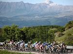
Attend Giro d'Italia, Italy
The Giro d'Italia (Tour of Italy) is an annual multiple stage bicycle race primarily held in Italy, while also occasionally passing through nearby countries. The race was first organized in 1909 to increase the sales for the newspaper La Gazzetta dello Sport; however it's now currently run by RCS Sport. The race has been held annually since its first edition in 1909 e... -
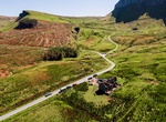
Hike, Ride or Drive Gleniff Horseshoe Drive, Ireland
Gleniff Horseshoe is a 6 mile single lane loop road with spectacular views and dramatic and wild Dartry Mountains. -
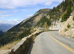
Cycle Going-to-the-Sun Road, Glacier National Park, Montana
Biking the 50 miles (80 km) of the Going-to-the-Sun Road in Glacier National Park in Montana, USA is possibly the most exhilarating and challenging way to see one of the United States' most precious natural wonders. As cyclists pump their legs and wind around curves while climbing up the Continental Divide at Logan Pass they will gain a new found appreciation of the o... -
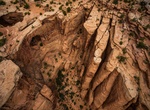
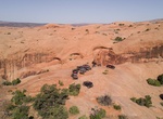
Off-road or Mountain Bike Gold Bar Rim Safari Trail, Moab, Utah
Popular hard-core trail with great view at top from cliff rim that stands about 1200 feet above Highway 191's path in Moab Canyon. Gold Bar Rim Safari Trail connects Golden Spike Safari Trail with Gemini Bridges 4x4 Road. Often driven downhill in opposite direction described here as continuation of Golden Spike. For modified vehicles with very high ground clearance, ... -
Drive or Cycle Gold Belt Tour Scenic and Historic Byway, Colorado
The Gold Belt Tour Scenic and Historic Byway is a National Scenic Byway, a Back Country Byway, and a Colorado Scenic and Historic Byway located in Fremont and Teller counties, Colorado, USA. The byway is named for the Gold Belt mining region. The Cripple Creek Historic District is a National Historic Landmark. The byway forms a three-legged loop with the Phantom Canyo... -
Cycle across Golden Gate Bridge, San Francisco, California
No journey to San Francisco is complete without a trip to the iconic Golden Gate Bridge and there's no better to experience it than by bike. Take your time weaving through the crowds on the eastern sidewalk and enjoy the city views, or speed along on the bike-only western sidewalk and marvel at the engineering and architectural genius behind the bridge. Or better yet,... -
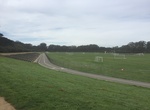
Cycle Golden Gate Park Polo Fields, California
The Polo Fields is a large multi-purpose stadium and sporting field in San Francisco's Golden Gate Park.Despite its name, polo is rarely played on the Polo Fields. The facility has a multitude of uses.There are six regulation soccer fields surrounded by a .67-mile cycle track.Wooden bleachers overlook the field and track.Above the bleachers is a 0.75-mile (1,210 m) di... -
Off-road or Mountain Bike Golden Spike Safari Trail, Moab, Utah
Golden Spike is in the middle of two other difficult trails: Poison Spider and Gold Bar Rim and is one of the toughest and most time-consuming trails in the Moab area.. Golden Spike is a dream trail of challenging obstacles, which include such well-known names as the Launch Pad, Skyline Drive, the Golden Crack, the Golden Stairs, The Wall and Double Whammy. Much of th... -
Mountain Bike Gooseberry Mesa National Recreation Trail, Utah
Gooseberry Mesa National Recreation Trail is located on Gooseberry Mesa in southern Utah's red rock country. At an elevation of 5,200 feet, views from the mesa rims are spectacular. Rising to the north are the massive sandstone sentinels of Zion National Park. Spread out below the west rim is a panorama of colorful desert mesas and water carved canyons. The Gooseberr...


Price: $1251.74