Give us feedback!


 See all

Our philosophy is simple. We want to encourage you to dream. BIG! Then we help you plan your trip, get the most out of it while you're traveling and help you share your experience with friends.
Join Now It's FREE
Dream Packages
Duration: 8 hours
Price: $246.07
Price: $246.07
Duration: 15 hours
Price: $571.07
Price: $571.07
Duration: 3 days
Price: $499.72
Price: $499.72
Dreams Still To Do
Checked-Off Dreams
Dreams Still To Do
Checked-Off Dreams
Advertisement
Explore Cycling
-
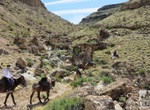
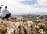
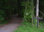
Ride Echo Canyon - Fossil Ridge Loop, Nevada
Blue Diamond Hill, across from the main part of Red Rock Canyon, offers some great hiking trails. Many of these were created by mountain bikers and some were created by the horseback riding concession that operates near the trailhead. Parking for this hike is along SR 159 just outside the entrance to the horseback riding road. The hike takes you in the road and then r... -
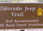
Off-road or Mountain Bike Eldorado Jeep Trail, Arizona
The Eldorado Jeep Trail Road is 13 miles of backcountry trail located in Arizona. It follows washes west from U.S. 93, running through the Black Mountains to the shore of Lake Mohave. The road is mostly smooth and flat (although the word “Jeep” in the name implies otherwise) with a just a few rocky areas. This road is a good 25 miles south of Hoover Dam an... -
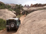
Off-road or Mountain Bike Elephant Hill Road, Canyonlands National Park, Utah
One of the most technical four-wheel-drive roads in Utah, Elephant Hill presents drivers and mountain bikers with steep grades, loose rock, stair-step drops, tight turns and tricky backing. Once over the hill, equally challenging roads lead to various features as well as BLM lands south of the park. No water is available at the campsites, but vault toilets are provide... -
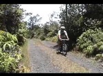
Mountain Bike Escape Road, Hawaii Volcanoes National Park, Big Island, Hawaii
The 8 mile (685 feet elevation gain) Escape Road in Hawaii Volcanoes National Park is a great trail for mountain bikers. The Escape Road was originally built in the 1800's to transport tourists and provisions to the crater from boats on the coast. Now the Escape Road serves as an alternate way out of the Kilauea Crater area in case the Chain of Craters Road gets block... -
Hike, Mountain Bike or Off-road to Eureka Peak, Joshua Tree National Park, California
Eureka Peak is a mountain in the Black Rock Canyon region of Joshua Tree National Park in the U.S. state of California. The peak is the 4th highest summit in the park after Quail Mountain, Queen Mountain and Inspiration Peak. There are great view of the Morongo Basin and Palm Desert, all the way out to Interstate 10 and Mount San Jacinto. Eureka Peak hike from Black R... -
Trek or Cycle Evliya Çelebi Way - Hersek, Turkey to Mecca, Saudi Arabia
The Evliya Çelebi Way is a cultural trekking route celebrating the early stages of the journey made in 1671 to Mecca by the eponymous Ottoman Turkish gentleman-adventurer, Evliya Çelebi. Evliya travelled the Ottoman Empire and beyond for some 40 years, leaving a 10 volume account of his journeys. The Evliya Çelebi Way is a c.600 km-long trail... -
Hike or Ride Father Juniper Serra Trail, Mission Trails Regional Park, California
Hike or ride the 1.8 mile Father Juniper Serra Trail in Mission Trails Regional Park. Cars are allowed on this road (one-way from visitor center to Old Dam). -
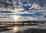
Drive or Cycle Firehole Lake Drive, Yellowstone National Park, Wyoming
Firehole Lake Drive is a 3.3-mile loop drive takes visitors past Great Fountain Geyser, White Dome Geyser and Firehole Lake. From Fountain Paint Pot, drive 1.2 mile (2 km) south (toward Old Faithful) to Firehole Lake Drive. Firehole Lake Drive is a one-way road south of Madison Junction in Yellowstone National Park. -
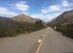
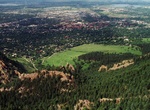
Hike or Bike Flagstaff Mountain, Colorado
Flagstaff Mountain is a foothill on the eastern flank of the Front Range of the Rocky Mountains near Boulder, Colorado. The 6,983-foot (2,128 m) peak is located in Boulder Mountain Park, 3.5 miles (5.6 km) southwest of downtown Boulder. There are several view points with fantastic views of Boulder. The road up the mouintain is a classic road ride for many area cyclis... -
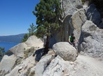
Mountain Bike Flume Trail, Lake Tahoe, Nevada
The Flume Trail in Lake Tahoe area is a moderately difficult one way 14 mile ride at 7000′ to 8000′ feet in elevation with over a 1000′ of climbing in the first four miles and 4.5 miles of single track. The trail traverses above several steep sections, so those afraid of heights be forewarned. The trail starts just north of Spooner Lake. Riders can... -
Ride in Forrest GrapeRide, Marlborough, New Zealand
Combine a love of cycling with a love of fine wines by riding in the Forrest GrapeRide. This event is the South Island’s biggest and most popular recreational road cycling event. The classic course traverses a 101km or 42km circuit through some of the most stunning scenery New Zealand has to offer and has been described as a ride through nature’s photo alb... -
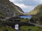
Drive or Cycle Gap of Dunloe, Ireland
The Gap of Dunloe is a narrow mountain pass between Macgillycuddy's Reeks (west) and Purple Mountain (east) in County Kerry, Ireland. It is about 11 km (6.8 mi) from north to south. Within it are five lakes: Coosaun Lough, Black Lake, Cushnavally Lake, Auger Lake, and Black Lough (north to south). These lakes are connected by the River Loe. Between the first two lakes... -
Ride or Hike Garda by Bike, Lake Garda, Italy
This 140 km (87-mile) long bike trail goes around Lake Garda, Italy’s largest lake. The Garda by Bike project has been underway for the past few years, and is scheduled to be completed by 2021. It is using partially existing bike paths with new tracks that will be built. The bike loop is intended for all skill levels. There are no steep grades and the path is p... -
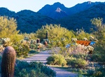
Hike or Ride Gateway Loop Trail, McDowell Sonoran Preserve, Arizona
A 4.5 mile loop that wanders up to a low saddle before winding back to the Gateway Trailhead. The length and grade changes make this a moderately difficult hike, but one worth trying. Make your way at an enjoyable pace while enjoying the wildflowers and wildlife. Kids with hiking experience may be able to enjoy this hike. Follow the main trail from the parking area t... -
Hike or Ride Gatlinburg Trail, Great Smoky Mountains, Tennessee
The Gatlinburg Trail is one of two walking paths on which visitors can walk dogs and bicycle. Pets and bicycles are prohibited on all other park trails. The trail travels 1.9 miles one-way from the Sugarlands Visitor Center to the outskirts of the city of Gatlinburg, TN. It is relatively flat and runs through the forest along side the West Prong of the Little Pigeon R...


Price: $1251.74