Give us feedback!


 See all

Our philosophy is simple. We want to encourage you to dream. BIG! Then we help you plan your trip, get the most out of it while you're traveling and help you share your experience with friends.
Join Now It's FREE
Dream Packages
Duration: 3 days
Price: $499.72
Price: $499.72
Duration: 8 hours
Price: $246.07
Price: $246.07
Duration: 15 hours
Price: $571.07
Price: $571.07
Dreams Still To Do
Checked-Off Dreams
Dreams Still To Do
Checked-Off Dreams
Advertisement
Explore Cycling
-
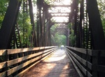
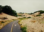
Bike Pine Creek Rail Trail, Pennsylvania
The Pine Creek Rail Trail is a rail trail in the Appalachian Mountains of north-central Pennsylvania. The trail begins just north of Wellsboro, runs south through Pine Creek Gorge (also known as the Grand Canyon of Pennsylvania), and ends in Jersey Shore. A 2001 article in USA Today named the 65-mile (105 km) long trail one of "10 great places to take a bike tour" in ... -
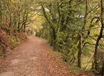
Mountain Bike or Hike Pinhoti National Recreation Trail, Alabama & Georgia
The Pinhoti Trail is a long-distance trail, 335 miles (540 km) long, located in the United States within the states Alabama and Georgia. The trail's southern terminus is on Flagg Mountain (the southern most Appalachian peak that rises over 1,000 feet (300 m) which is located near Weogufka, Alabama. The trail's northern terminus is where it joins the Benton MacKaye Tra... -
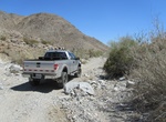
Off-road or Mountain Bike Pinkham Canyon-Thermal Canyon Roads, Joshua Tree National Park, California
Pinkham Canyon-Thermal Canyon Roads is a challenging 20-mile (32.4-km) road begins just south of Cottonwood Visitor Center, travels along Smoke Tree Wash, then cuts down Pinkham Canyon, exiting onto a service road that connects to I-10. Or you can pass Pinkham Canyon and continue on to Thermal Canyon Road. Sections of these roads run through soft sand and rocky flood ... -
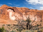
Mountain Bike or Hike Pipe Dream Trail, Moab, Utah
Pipe Dream is a singletrack mountain bike trail in Moab, located along the southwest hills below the rim of Moab Valley parallel to Highway 191. It can be done as an out-and-back of 9.4 miles, or as an 8.2-mile loop ride by including the Pipeline Trail. -
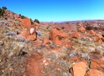
Off-road or Mountain Bike Poison Spider Mesa Safari Trail, Moab, Utah
This is one of the most popular trails in Moab and is often combined with Golden Spike and Gold Bar Rim. (Both available as FunTreks eGuides.) Poison Spider Mesa is a fun-filled combination of challenging obstacles and incredible scenery. This trail is rated as hard. There are sound harder sections but if you have a good spotter you can make it. Don't miss impressive... -
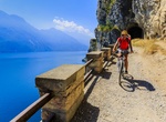
Hike or Ride Ponale Road (Strada del Ponale), Lake Garda, Italy
The Ponale road, Ponale highway or lately Alpine trail D 01 is a former highway that was the first road connection between the Garda Lake area and the Ledro valley. It was constructed by Giacomo Cis between 1848 and 1851 in the steep north-western ranges of the Garda Lake. The road suffered from regular landslides, so a separate road tunnel has been built in 1998. Sin... -
Walk or Cycle the Portuguese Way (Caminho Portugués), Portugal & Spain
The Portuguese Way (Caminho Portugués) is a route for pilgrims looking for a more rural experience on the Camino de Santiago. The full Portuguese Way takes just over 1 month to complete is walking or choose to walk/ride a section. -
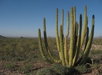
Drive or Mountain Bike Pozo Nuevo Road, Organ Pipe Cactus National Monument, Arizona
Pozo Nuevo Road is a 14 mile road that connects Puerto Blanco Drive with Bates Well Road. Offers views of the Cipriano Hills, the Growler Valley, and the historic Pozo Nuevo line-camp. High clearance or 4x4 recommended. Closed during the winter. Bikes are allowed on all roads open to vehicle traffic. Biking is not allowed on any trails. -
Mountain Bike around Prescott, Arizona
The area around Prescott, Arizona has 250 miles of all types of trails. The Willow Dells Slickrock Trails are some of the most challenging and going through the otherworldly Granite Dells is another great area. -
Ride Province Lands Bike Trail, Cape Cod, Massachusetts
Province Lands Bike Trail starts from Province Lands Visitor Center in Provincetown. The loop route is 5.25 miles long but there are trail extensions to Herring Cove Beach, Race Point Beach and Bennett Pond to add miles. Distance in miles: Loop trail 5.45 Herring Cove Beach spur 1.10 Race Point Beach spur .50 Bennett Pond spur .25 Access points: Beech For... -
Drive or Mountain Bike Puerto Blanco Drive, Organ Pipe Cactus National Monument, Arizona
Puerto Blanco Drive is the other popular road in the park. The 37 mile drive provides access to the Pinkley Peak Picnic Area, Red Tanks trail head, Senita Basin and Quitobaquito Springs. Several stops along the way provide wonderful views and information on the ecology and culture of the Sonoran Desert. The Puerto Blanco Drive was completely reopened in 2014. Be advi... -
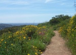
Summit Pyle’s Peak, Mission Trails Park, California
Pyles Peak Trail is a 5.6-6.8 miles out and back trail located in Mission Trails Regional Park. The moderate hike offers scenic views, you can hike or trail run. The trail is open from October until June. The hike allows leashes dogs. This trail is one of the 5-Peak Challenge trails. Take a photo at the summit at each of the trails and show it to the Mission Trails P... -
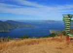
Hike or Mountain Bike Queen Charlotte Track, Marlborough Sounds, New Zealand
The Queen Charlotte Track, located at the top of New Zealands South Island in the Marlborough Sounds is a 71km-long trek (hike) between the Queen Charlotte and Keneperu Sound. The track stretching from Ship Cove to Anakiwa offers lush coastal forest and skyline ridges with unsurpassed views of the islands and bays of the sounds. It can be done in either direction, but... -
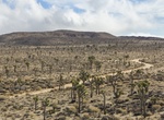
Off-road or Mountain Bike Queen Valley Roads, Joshua Tree National Park, California
Queen Valley Roads is a network of roads in Joshua Tree National Park, totaling 13.4 miles (21.7 km), cross this valley of boulder piles and Joshua trees. A bike trip can begin at Hidden Valley or Big Horn Pass, opposite Geology Tour Road. Bike racks have been placed in this area so visitors can lock their bikes and go hiking. -
Ride in RAGBRAI, Iowa
RAGBRAI is an acronym for Register's Annual Great Bicycle Ride Across Iowa. It is a non-competitive bicycle ride across Iowa that draws recreational riders from across the United States and overseas. Riders begin at a community on Iowa's western border and ride to a community on Iowa's eastern border, stopping in towns across the state. RAGBRAI is limited to 8,500 wee...


Price: $1251.74