Give us feedback!


 See all

Our philosophy is simple. We want to encourage you to dream. BIG! Then we help you plan your trip, get the most out of it while you're traveling and help you share your experience with friends.
Join Now It's FREE
Dream Packages
Duration: 15 hours
Price: $571.07
Price: $571.07
Duration: 8 days
Price: $1251.74
Price: $1251.74
Duration: 8 hours
Price: $246.07
Price: $246.07
Dreams Still To Do
Checked-Off Dreams
Dreams Still To Do
Checked-Off Dreams
Advertisement
Explore Cycling
-
Off-road Old Ore OHV Road, Big Bend National Park, Texas
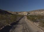
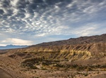
Old Ore OHV Road is a 26 miles (43km) dirt road located in Big Bend National Park between Dagger Flat Road and Rio Grande Village Road. Used in the early 1900s to transport ore from Mexican mines to the railroad station at Marathon, the Old Ore Road generally follows the route used by mule and pack trains a century ago. This road is rough and requires a sturdy vehicle... -
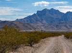
Off-road or Mountain Bike Old Ranger Station Road, Arizona
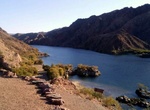
Old Ranger Station Road is 4.26 miles of backcountry road close to the Colorado River and the ruins of the Gauger’s Residence Site. When you reach the end of the road, hike the remaining 0.75 miles to the gauging station and Colorado River. Old Ranger Station Road starts on the west side of Hwy 93 south of Hoover Dam. -
Mountain Bike down Ollagüe Volcano, Chile & Bolivia
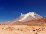
Ollagüe is a massive andesite stratovolcano in the Andes Mountains, on the border between Bolivia and northern Chile. It is located southeast of the village that shares its name. It has a prominence of 1,686 metres (5,531 ft; 1.048 mi), towering over a mile above the surrounding terrain. On the northwest side of the mountain a disused switchback road, whose highe... -
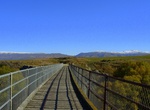
Hike or Ride Olympic Discovery Trail, Washington
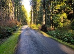
The Olympic Discovery Trail is a designated non-motorized, multi-use trail spanning the north end of the Olympic Peninsula in Washington. The route spans around 140 miles between Port Townsend, Washington and La Push, Washington. As of August 2017, 80 miles of this trail are complete and additional miles under construction. The remainder of the route can be ridden usi... -
Hike or Ride Otago Central Rail Trail, New Zealand
The Otago Central Rail Trail is a 150-kilometre walking, cycling and horse riding track in the South Island of New Zealand. A pioneering project for New Zealand, the successful cycle trail joined the New Zealand Cycle Trail umbrella organisation in 2012, having been one of the inspirations for it. The trail runs in an arc between Middlemarch and Clyde, along the route... -
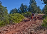
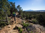
Mountain Bike Outer Limits Trail, Sedona, Arizona
Outer Limits Trail near Sedona is most easily ridden from the Aerie Trailhead to the Girdner trailhead. Mainly flowy and fast wiht a few technical parts, especially the descent down to the creek bed, may require walking for non-experts. -
Bike Paint Gap Road, Big Bend National Park
Park at the junction of the paved road and the Paint Gap Road. The road has a variety of surfaces including sand and rocks, and is especially rough near the end. Return the same way. -
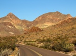
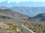
Bike Panther Junction to Castolon via the Ross Maxwell Scenic Drive, Big Bend National Park
This ride travels through some of the most scenic terrain in the park. It skirts the Chisos Mountains and passes interesting geologic features and historic sites. Although the loss of elevation between Panther Junction and Castolon is 1,580ft., the terrain is challenging with many steep hills. -
Bike Panther Junction to Rio Grande Village, Big Bend National Park
Although there are some hills the ride is mostly downhill as the elevation drops 1,900ft. over the course of the ride. Be wary of large motorhomes and trailers travelling this road, especially during fall, winter and spring. For a variation, ride to the Hot Springs Historic District on the 2-mile unpaved spur road 16 miles from Panther Junction. Your shuttle can meet ... -
Bike Panther Junction to Rio Grande Village via the Glenn Springs Road, Big Bend National Park
Ride six miles toward Rio Grande Village on the paved road, then turn onto Glenn Springs Road. Follow it for 15 miles as it skirts the Chisos Mountains and leads to a desert spring before joining the River Road. Turn left and follow the River Road for 9.6 miles to its junction with the paved road. Turn right and ride on the paved road for 4 miles to Rio Grande Village... -
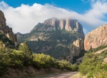
Ride Panther Junction to the Chisos Basin, Big Bend National Park
Ride three miles of gradual uphill west of Panther Junction to the Chisos Basin Junction. Turn left and ride seven miles to the Chisos Basin. The road is very steep, with 15% grades. The elevation gain is 1,650ft. Watch for traffic and be ready to pull off the road if necessary. This ride is an aerobic challenge even for those in excellent physical condition. The ride... -
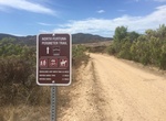
Hide or Ride Perimeter Trail North, Mission Trails Regional Park, California
Hike, mountain bike or ride horses along the Perimeter Trail North in Mission Trails Regional Park. The trailhead starts at East Fortuna Staging Area (Mast Blvd and Route 52). The trail goes West along the southern part of Route 52. -
Mountain Bike Phil’s World, Colorado
The Phil's World 28-mile trail system sits atop a southwest desert mesa approximately four miles from Cortez, Colorado and consists of classic single track riding intermixed with segments of challenging slickrock. Trail difficulty ranges from beginner to intermediate. The majority of trails within the system are mildly technical with limited extended uphill sections. ... -
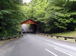
Drive or Bike Pierce Stocking Scenic Drive, Michigan
The Pierce Stocking Scenic Drive is a scenic route within Sleeping Bear Dunes National Lakeshore, in western Northern Michigan in the United States. The roadway, with its "scenic vistas and gentle curves", is located off state highway M-109 between Empire and Glen Arbor. It runs for 7.4 miles (11.9 km) through forest and dunes areas, providing access to scenic overloo... -
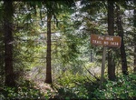
Hike, Ski or Ride Pig Iron Trail, Oregon
This trail is a left-over section of the old Two Rivers trail from Clearwater River over Pig Iron Mountain to the North Umpqua River. A steep hike with challenging terrain, the trail takes hikers through unique and interesting geological areas. At the end of the trail, turn left to hike about 0.25-mile uphill to the Pig Iron Lookout, a secondary lookout which is usual...
Price: $499.72