Give us feedback!


 See all

Our philosophy is simple. We want to encourage you to dream. BIG! Then we help you plan your trip, get the most out of it while you're traveling and help you share your experience with friends.
Join Now It's FREE
Dream Packages
Duration: 8 hours
Price: $246.07
Price: $246.07
Duration: 8 days
Price: $1251.74
Price: $1251.74
Duration: 3 days
Price: $499.72
Price: $499.72
Dreams Still To Do
Checked-Off Dreams
Dreams Still To Do
Checked-Off Dreams
Advertisement
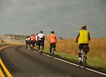
Explore Cycling
-
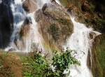
Cycle to Nam Tok Waterfall, Hsipaw, Myanmar
Nam Tok Water fall is close to Hsipaw town. It’s quite impressive and the way to get there is beautiful. Many people go by bicycle for a change from walking. -
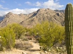
Hike or Ride Nature Trail, Catalina State Park, Arizona
Nature Trail is an easy 1 mile loop begins at the Trailhead parking lot, climbs a hill, then meanders through low foothills with typical desert scrub vegetation. Trailside signs feature local plants and animals, in addition to climate and geology information. Plan on 45 minutes of walking time. -
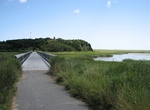
Ride Nauset Bike Trail, Cape Cod, Massachusetts
The Nauset Bike Trail in Cape Cod starts at the Salt Pond Visitor Center and goes for 1.6 miles to Coast Guard Beach. -
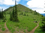
Hike or Mountain Bike Noble Knob, Rainier National Park
This is a great alpine ridge walk just outside of Rainier National Park in the Norse Peak Wilderness. This isn't a killer climb as there is minimal elevation change thus the views are attainable for the whole family. The trail is easy to follow all the way to Noble Knob around Mutton Mountain which you can also run up if you'd like. This trail is open to mountain bike... -
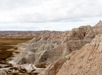
Mountain Bike Northeast-Big Foot Loop, Badlands National Park, South Dakota
A long but fairly easy ride after the initial hill climb, this route takes you through ranch land and badland formations. Starting from the Ben Reifel Visitor Center, ride up the steep Cedar Pass along the Badlands Loop Road. Once at the top of the Pass, turn left on the gravel Old Northeast Road. Follow this road six miles past the park boundary to a junction. Contin... -
Mountain Bike Northeast Loop, Badlands National Park, South Dakota
This is also a fairly easy ride after the initial climb up Cedar Pass. Start from the Ben Reifel Visitor Center, riding up the steep Cedar Pass. Once at the top, turn left on the unpaved Old Northeast Road. Follow this route for 6 miles past the park boundary to a junction. Bear right (east), parallelling Interstate 90 until you reach Cactus Flat. Here you will find a... -
Hike or Ride North Rim Bridle Path, Grand Canyon, Arizona
The North Rim Bridle Path is 1.2 miles (2 km) one-way and 45 minutes one-way, follows the road as it connects Grand Canyon Lodge with North Kaibab Trailhead. Pets on a leash and bicycles are permitted on this hard-packed trail. -
Hike or Ride North Umpqua Trail, Oregon
Hiking, horseback riding, mountain biking, photography, fishing, and sight-seeing opportunites abound in the spectacular settings of the North Umpqua Trail in the Cascade mountains of the Pacific Northwest. The trail is about 79 miles (127 km) long. It is broken up into 12 segments, ranging from 3.5 to 13 miles (21 km) in length. The trail ranges in elevation from 80... -
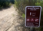
Hike or Mountain Bike Oak Grove Loop Trail, Mission Trails Regional Park, San Diego, California
The Oak Grove Trail leads to a small oak woodland with majestic coast live oaks and rare Engelmann oaks in Mission Trails Regional Park. -
Hike, Mountain Bike or Ski Ochre River Trail, Riding Mountain National Park, Manitoba, Canada
Ochre River Trail is 24.9 km (one-way) and situated deep within Riding Mountain National Park. Beginning just off Highway #10 and then winding its way through thick forest down to a parking lot on the north-eastern boundary of the park. There isn't another experience in Riding Mountain National Park that equals a trip on Ochre River Trail. Highlights along this trail... -
Hike or Ride Oconaluftee River Trail, Great Smoky Mountains, North Carolina
The Oconaluftee River Trail is one of two walking paths on which visitors can walk dogs and bicycle. Pets and bicycles are prohibited on all other park trails. The trail travels 1.5 miles one-way from the Oconaluftee Visitor Center to the outskirts of the city of Cherokee, NC. It is relatively flat, but does have a few small hills. The trail runs through the forest a... -
Hike or Bike Ohio & Erie Canal Towpath Trail, Cuyahoga Valley National Park, Ohio
The multi-purpose Ohio & Erie Canal Towpath trail was developed by the National Park Service and is the major trail through Cuyahoga Valley National Park. From it visitors can make connections to many of the natural and historic sites in the park and to other trails that intersect it along the way. The Towpath Trail follows the historic route of the Ohio & Er... -
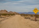
Off-road or Mountain Bike Old Dale Road & Gold Crown Road (Dale Mining District), Joshua Tree National Park, California
Old Dale Road leads to an abundance of mining history in both the Dale and Monte Negras mining districts. This 23-mile (37.3-km) Old Dale Road starts at the same point as Black Eagle Mine Road off the paved Pinto Basin Road. The first 11 miles (17.8 km), cross Pinto Basin, a flat, sandy, dry-lake bed. Leaving the basin, the road climbs a steep hill, then crosses the p... -
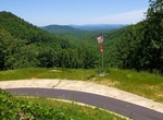
Cycle Old Fort Mountain, North Carolina
While the trail is only 3.6 miles one way (plus another 1/2 mile from the parking area), it climbs 900 feet in elevation from Old Fort to Ridgecrest (near Black Mountain). Begin at the Old Fort entrance to bike the uphill portion first (even, gentle climb), then you can coast down on your bicycle as your reward. It's an eight mile roundtrip from the Pisgah Forest picn... -
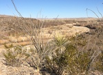
Drive Old Maverick Road, Big Bend National Park, Texas
The Old Maverick Road runs between Maverick Junction and Santa Elena Canyon. It is a 14-mile improved dirt road that passes along the Terlingua Creek badlands on the west side of the park. A number of historic sites are located near the road that you may visit as you gradually descend to the Rio Grande and Santa Elena. While usually passable for most vehicles, this r...
Price: $571.07