Give us feedback!


 See all

Our philosophy is simple. We want to encourage you to dream. BIG! Then we help you plan your trip, get the most out of it while you're traveling and help you share your experience with friends.
Join Now It's FREE
Dream Packages
Duration: 15 hours
Price: $571.07
Price: $571.07
Duration: 8 days
Price: $1251.74
Price: $1251.74
Duration: 3 days
Price: $499.72
Price: $499.72
Dreams Still To Do
Checked-Off Dreams
Dreams Still To Do
Checked-Off Dreams
Advertisement
Explore Cycling
-
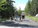
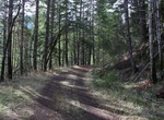
Hike or Ride Rainy Lake Recreation Trail, Voyageurs National Park, Minnesota
This trail offers visitors a wonderful experience as it meanders along the park road, into the woods, and around rock outcrops. Bicyclists, walkers, runners, and snowshoers will be treated to views of forest, lake, and marsh scenery. The 12-mile trail goes from International Falls to Rainy Lake, the northern gateway to Voyageurs National Park -
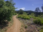
Hike or Mountain Bike Ranch Trail #62, Prescott National Forest, Arizona
Ranch Trail #62 begins in manzanita, pinyon pine, mountain mahogany, and low-growing oak. It climbs considerably to its junction with Boy Scout Trail #126, where Government Canyon lies to the west. From here this trail continues its ascent, offering panoramic views of Lynx Lake, Prescott Valley, Bill Williams Mountain and the San Francisco Peaks. At the trail’s ... -
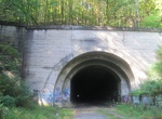
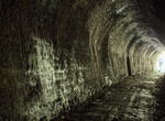
Hike or Ride through Rays Hill Tunnel, Rays Hill, Pennsylvania
Rays Hill Tunnel is one of three original Pennsylvania Turnpike tunnels that were abandoned (this one in 1968) after two massive realignment projects. The others included the Sideling Hill Tunnel, and farther west, the Laurel Hill Tunnel. Rays Hill Tunnel is 3,532 feet (1,077 m) long. It was the shortest of the seven original tunnels on Pennsylvania Turnpike. Due to i... -
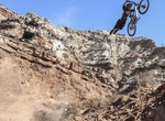
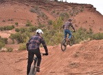
Attend Red Bull Rampage, Utah
The Red Bull Rampage is an invite-only freeride/downhill mountain bike competition held near Zion National Park in Virgin, Utah, USA, just to the north of Gooseberry Mesa. Previously it was held off the Kolob Terrace Road, on the western boundary of Zion National Park. The competition was held from 2001–2004 and then canceled due to the increasing risk competito... -
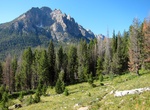
Hike or Mountain Bike Redfish Lake Trail, Redfish Lake, Idaho
Redfish Lake Trail is a 14.9 mile out and back trail located along the western side of Redfish Lake, Idaho. Dogs are also able to use this trail but must be kept on leash. -
Mountain Bike Red Fleet Downhill Flow Trail, Vernal, Utah
Red Fleet Downhill Flow Trail is located near Vernal, Utah. The trail offers a unique experience for visitors looking to hone their mountain bike speed and technical skills. Trail users can select from a green (easy), blue (intermediate), or double black (advanced) course based on their experience, and comfort levels. The trail system is located 12 miles outside of ... -
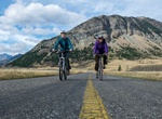
Drive or Bike Red Rock Parkway, Waterton Lakes National Park, Alberta, Canada
The Red Rock Parkway travels 15 km up the Blakiston Valley through rolling grasslands and ends at Red Rock Canyon. It is the best place to experience Waterton's classic prairie meeting mountain landscape. During your trip, be sure to stop at the scenic pulloffs, many of which have interpretive displays. At the end of the parkway, a self-guided trail loops around Red ... -
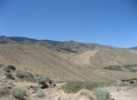
Bike or Hike Reno's Hole-In-The-Wall Trail, Reno, Nevada
Hole in the Wall Trail is a 5 mile out and back trail located near Reno, Nevada. -
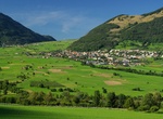
Cycle down Reschen Pass to Merano, Italy
The Reschen Pass is a pass (1504 m) over the Main chain of the Alps, connecting the Inn River valley in the northwest with the Vinschgau valley in the southeast. Since 1919, the border between Italy and Austria runs approximately along the watershed, the pass summit being completely on Italian territory. Begin you ride at the top of the pass and go downhill almost all... -
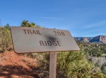
Mountain Bike Ridge Trail, Sedona, Arizona
Despite humble beginnings, this slightly obscure trail offers a breathtaking vantage of Cathedral Rock and Oak Creek Canyon. Along the way, expect shifts in scenery unparalleled by trails of comparable length. The Ridge Trail is a steep climb that culminates in a transcendent view into Red Rock Crossing and back towards Thunder Mountain. Advanced riders may cross the ... -
Hike or Mountain Bike Rimutaka Rail Trail, New Zealand
The Rimutaka Rail Trail is a walking and cycling track in the North Island of New Zealand. It runs between Maymorn and Cross Creek, and follows 22 kilometres (14 mi) of the original route of the Wairarapa Line over the Rimutaka Ranges between the Mangaroa Valley and the Wairarapa, including the world-famous Rimutaka Incline. Parts of the trail are also used by vehicle... -
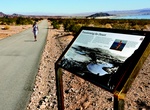
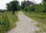
Ride or Walk River Mountains Loop Trail, Nevada
River Mountains Loop Trail is a must-do for cyclists and walkers alike. A 34-mile paved loop trail (16.7 miles of which are in Lake Mead National Recreation Area) boasts scenic views, plentiful wildlife and the vast beauty of the Mojave Desert. This trail has several trailheads and journeys around the river mountains connecting the park, as well as Hoover Dam, Henders... -
Mountain Bike Riverview Trail (Umpqua), Oregon
The original North Umpqua Highway was built in 1926. Today this route is a six-mile side trail (#1530) that offers hikers and mountain bikers a loop opportunity when combined with the Mott Segment of the North Umpqua Trail and Highway 138. Access to the trail is either from Bogus Creek Campground on the west end or just off Highway 138 on Forest Road 38 on the east en... -
Hike or Bike Rock Island Trail State Park, Missouri
The Rock Island Spur of Katy Trail State Park is a state park in the U.S. state of Missouri that is 47-mile (76 km) rails to trails hiking and biking trail. Work on the trail was completed and the trail was opened on December 10, 2016 . The trail provides residents of the Kansas City region direct trail access to the 240 mi (390 km) Katy Trail State Park, the longest ... -
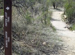
Hike or Ride Romero Canyon Trail, Catalina State Park, Arizona
Romero Canyon Trail is a 7.2 miles, one-way trail in Catalina State Park. No dogs in Desert Bighorn Sheep Management Area, beyond Montrose Pools — no bikes in the Pusch Ridge Wilderness — not recommended for horses beyond Montrose Pools Progressively difficult trail. Montrose Pools and Romeo Pools are shallow catchments on canyon streams that flow seasona...
Price: $246.07