Give us feedback!


 See all

Our philosophy is simple. We want to encourage you to dream. BIG! Then we help you plan your trip, get the most out of it while you're traveling and help you share your experience with friends.
Join Now It's FREE
Dream Packages
Duration: 4 hours 30 minutes
Price: $176.03
Price: $176.03
Duration: 3 hours
Price: $180.00
Price: $180.00
Duration: 4 hours
Price: $120.43
Price: $120.43
Duration: 8 hours
Price: $83.37
Price: $83.37
Dreams Still To Do
Checked-Off Dreams
Dreams Still To Do
Checked-Off Dreams
Advertisement
Explore Adventure Sports
-
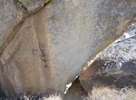
Hike Pictograph Trail, Anza-Borrego Desert State Park, California
The Pictograph Trail in Anza-Borrego Desert State Park is a 1.8-mile out and back hike to see large boulder that was used by Kumeyaay Indian painters who lived in the Anza-Borrego Desert over two thousand years ago. The pictographs are 1 mile from the trailhead. The trail ends 1.5 miles from the trailhead at a 100-ft. (30 m) dry fall in Smugglers Canyon. To get there ... -
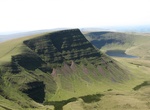
Hike Picws Du, Brecon Beacons National Park, Wales
Picws Du is the second highest peak of the Carmarthen Fans (or, in WelshBannau Sir Gaer) in the Carmarthenshire section of the Black Mountain in the west of the Brecon Beacons National Park in south Wales. The highest peak is Fan Foel immediately next along the ridge and it is a subsidiary summit of Fan Brycheiniog. Picws Du falls within Fforest Fawr Geopark and its p... -
Watch Elephant Seal's at Piedras Blancas State Marine Reserve , San Simeon, California
Piedras Blancas State Marine Reserve (SMR) and Piedras Blancas State Marine Conservation Area (SMCA) are two adjoining marine protected areas that lie offshore of San Luis Obispo County on California’s central coast. The combined area of these marine protected areas is 19.68 square miles (51.0 km2). The SMR protects all marine life within its boundaries. Fishing... -
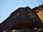
Hike Piedras Marcadas Canyon Trail, Petroglyph National Monument, New Mexico
Located in the north-eastern tip of the monument, this moderate undeveloped trail system is 1.5 miles round-trip. Water is not available. No restroom facilities. No shade. See approximately 300-500 petroglyphs in 1.5 hours. Leashed pets allowed. A free trail guide is available at the visitor center. Located off Golf Course Road at Jill Patricia Street. Parking lot is... -
Hike Piegan Pass Trail via Siyeh Bend Trail, Glacier National Park, Montana
Piegan Pass Trail is a 24.7 mile out and back trail located in Glacier National Park. The trailhead at Siyah Bend is along Going-to-the-Sun Road 2.2 miles east of Logan Pass. Hikers start off at the Siyeh Bend Trailhead and climb up to meet the Continental Divide Trail at about mile 1.1. Going right goes down to the Jackson Glacier Overlook. Turn left to head towards... -
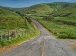
Drive Pierce Point Road, Point Reyes National Seashore, California
Pierce Point Road begins off Sir Francis Drake Blvd near Seahaven and ends at Point Pierce Ranch. Some of the park's roads and parking lots are closed to or do not have space for recreational vehicles (RVs) and vehicles pulling trailers. If you are traveling with a trailer or are driving an RV towing a passenger vehicle, consider unhitching at the bus/RV/trailer-only ... -
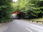
Drive or Bike Pierce Stocking Scenic Drive, Michigan
The Pierce Stocking Scenic Drive is a scenic route within Sleeping Bear Dunes National Lakeshore, in western Northern Michigan in the United States. The roadway, with its "scenic vistas and gentle curves", is located off state highway M-109 between Empire and Glen Arbor. It runs for 7.4 miles (11.9 km) through forest and dunes areas, providing access to scenic overloo... -
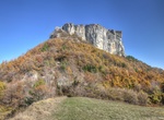
Hike to Pietra di Bismantova, Italy
The Pietra di Bismantova is a geological formation in the Reggiano Apennines, in thecomuneof Castelnovo ne' Monti, province of Reggio Emilia, central Italy, c. 45 km from Reggio Emilia. It has the shape of a narrow, quasi-cylindrical plateau (measuring 1 km x 240 m) whose steep walls emerge c. 300 m as an isolated spur from the nearby hills. The top has an elevat... -
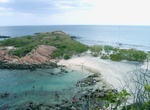
Dive Pigeon Island National Park, Sri Lanka
Pigeon Island National Park is one of the two marine national parks of Sri Lanka. The national park is situated 1 km off the coast of Nilaveli, a coastal town in Eastern Province, encompassing a total area of 471.429 hectares. The island's name derives from the rock pigeon which has colonized it. The national park contains some of the best remaining coral reefs of Sri... -
Windsurf or Kitesurf Pigeon Point, Tobago
Tobago's south-western Pigeon Point peninsula ideal for windsurfing or kitesurfing. It has clear, shallow waters encircled by the Buccoo Reef. Winds are best between December and June. During the rest of the year, the conditions are great for beginners. -
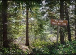
Hike, Ski or Ride Pig Iron Trail, Oregon
This trail is a left-over section of the old Two Rivers trail from Clearwater River over Pig Iron Mountain to the North Umpqua River. A steep hike with challenging terrain, the trail takes hikers through unique and interesting geological areas. At the end of the trail, turn left to hike about 0.25-mile uphill to the Pig Iron Lookout, a secondary lookout which is usual... -
Walk to Pigmy Cabin Site, Holcomb Valley, California
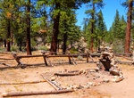
Pigmy Cabin Site is stop #10 of the Gold Fever Trail near Big Bear Lake. It's about 300 yards hike to the remains of this cabin. The cabin originally only was 6 feet tall with a door of only 4 feet - hence the name. -
Swim with Pigs on Big Major Spot Cay (Pig Island), Bahamas
Pig Beach, as the stretch of pristine white sand on Big Major Spot Cay in the Bahamas’ Exuma Cays has come to be known, is a place where swimming porcine encounters are a regular occurrence. Legend has it that some years ago sailors released a once domesticated but now decidedly feral pig couple who subsequently promulgated offspring that enjoy nothing more than... -
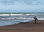
Surf Piha Beach, West Auckland, New Zealand
Piha is a northern New Zealand coastal settlement and is one of the most popular beaches in the area and a major day-trip destination for Aucklanders throughout the year, although especially so in summer. Piha is located 39 kilometres west of Auckland city centre, on the Tasman Sea coast to the north of the Manukau Harbour, on the western edge of the Waitakere Ranges.... -
Hike Pihea Trail & Alaka'i Swamp Trail, Kauai, Hawaii
The Pihea Trail is located in Koke'e State Park on Kauai. The trail starts at the Pu'u o Kila overlook (at the end of Highway 550). This hike combines some of the best features of Kauai into an unforgettable hiking experience. It follows the Kalalau Valley passing through forest of Ohi'a trees, ferns, koa, and other native vegetation. About 2 miles from the trail...


Price: $173.83