Give us feedback!


 See all

Our philosophy is simple. We want to encourage you to dream. BIG! Then we help you plan your trip, get the most out of it while you're traveling and help you share your experience with friends.
Join Now It's FREE
Dream Packages
Duration: 4 hours 30 minutes
Price: $176.03
Price: $176.03
Duration: 7 hours
Price: $179.00
Price: $179.00
Duration: 9 hours
Price: $109.14
Price: $109.14
Duration: 2 days
Price: $469.00
Price: $469.00
Dreams Still To Do
Checked-Off Dreams
Dreams Still To Do
Checked-Off Dreams
Advertisement
Explore Adventure Sports
-
Visit Pindaya Caves, Myanmar (Burma)
The Pindaya Caves, located next to the town of Pindaya, Shan State, Burma (Myanmar) are a Buddhist pilgrimage site and a tourist attraction located on a limestone ridge in the Myelat region. There are three "caves" on the ridge which runs north-south, but only the southern cave can be entered and explored. It is not known whether the other two penetrate for any extend... -
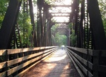
Hike or Ride to Pineapple Dump Bridge, Kauai, Hawaii
The remains of Pineapple Dump Bridge is located on the east side of Kauai north of Keālia Beach and south of Donkey/Paliku Beach. Walk along the Kauai Multiuse Path (Ke Ala Hele Makalae) to reach the bridge. From Kealia Beach the distance about a mile. The bridge was used by Pineapple farmers to dump their wastes into the ocean. -
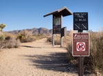
Hike Pine City and Pine City Canyon Trail, Joshua Tree National Park, California
Pine City and Pine City Canyon Trail is a 11 mile out and back trail located in Joshua Tree National Park. The highlight of this fairly flat trail is a dense stand of junipers and pinyon. The trail also goes to an old mining site. Backcountry camping is permitted in areas that are: 1 mile (1.6 km) from roads, 500 feet from trails and water sources, not day-use only a... -
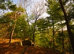
Hike Pine Cliff Trail, Governor Dodge State Park, Wisconsin
This is a wooded 2.5-mile trail which begins at Enee Point picnic area and ends at Lakeview Trail on the southeast side of Cox Hollow Lake. An additional 2-mile self-guided loop interprets area history, wildlife, vegetation and ecology. On this trail, you will encounter several steps, steep grades and rocky surfaces. Hikers will enjoy the scenic views above Cox Hollow... -
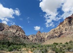
Hike Pine Creek Canyon Trail, Red Rock Canyon, Nevada
Pine Creek Canyon starts at the parking lot, then the trail runs downhill toward the canyon. The trail does get intersected at two points by Fire Ecology Trail and Dale's Trail, then forks near Old Wilson homestead foundation. The trail runs left, goes downhill, crosses a stream, then uphill toward an intersection with Arnight Trail. After crossing a wash, the main tr... -
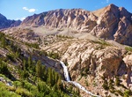
Hike Pine Creek Pass Trail, Bishop, California
Several trails start from the deep canyon cut by Pine Creek between Mount Tom and the Wheeler Crest. The Pine Creek Pass trail gives access to the Pine Lakes, along Pine Creek, and destinations beyond Pine Creek Pass. French Canyon and Humphreys Basin areas are popular destinations for visitors that go over Pine Creek Pass. From Bishop go north on Hwy 395 (approximat... -
Bike Pine Creek Rail Trail, Pennsylvania
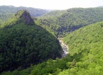
The Pine Creek Rail Trail is a rail trail in the Appalachian Mountains of north-central Pennsylvania. The trail begins just north of Wellsboro, runs south through Pine Creek Gorge (also known as the Grand Canyon of Pennsylvania), and ends in Jersey Shore. A 2001 article in USA Today named the 65-mile (105 km) long trail one of "10 great places to take a bike tour" in ... -
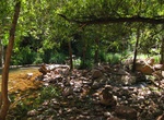
Hike Pine Creek Trail, Tonto Natural Bridge State Park, Arizona
Pine Creek Trail is about ½ mile long (400 feet developed - undeveloped in the creek bottom), leads to the Pine Creek natural area. Hiking shoes are recommended. Follow the arrows. Allow one hour. -
Off-road to Pine Grove, Nevada
Pine Grove is a ghost town in Lyon County, Nevada, United States. In 1866, gold-bearing rock was discovered in the area by William Wilson. The Wheeler Mine was established in the next year. Early settlers named the camp after the nearby Pine Grove Hills. By 1868, a post office had opened, along with a weekly newspaper. The population at the time was 200. Two steam-pow... -
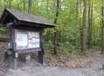
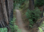
Hike Pine Grove Trail, Cuyahoga Valley National Park, Ohio
The 2.2 mile Pine Grove Trail is located near Ritchie Ledges at the Octagon Picnic Shelter. This kid-friendly route shows off the park’s diverse flora, with wildflowers at ground level and lush green hemlocks and oaks above. The nearby Forest Point Trail is a far easier half-mile and should take up to 30 minutes to trek. -
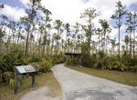
Hike Pineland Trail, Everglades National Park, Florida
This trail loops through a forest of pines, palmettos, and wildflowers. Seven miles (11km) from the main park entrance/ Ernest Coe Visitor Center. Wheelchair Accessible: Yes, though there are narrow and uneven places where roots have pushed the pavement up. -
Hike Pine Mountain State Scenic Trail, Kentucky
Pine Mountain State Scenic Trail is a 120 mi (193 km) trail under development in the U.S. state of Kentucky. Once completed, the trail will wind along Pine Mountain Ridge from the Breaks Interstate Park to Cumberland Gap National Historical Park. The park itself will cover a 1,000 acres (4.0 km2) band along Pine Mountain. As of May 2014, the trail is completed from th... -
Hike Pine Ridge Trail, Los Padres National Forest, California
The Pine Ridge Trail is the most popular hiking trail in the Ventana Wilderness of the Los Padres National Forest, California. The 19.5 miles (31.4 km) trail traverses the Ventana Wilderness from the Big Sur Station near sea level to China Camp on Tassajara Road at 5,000 feet (1,500 m). Built in 1916 by the Post family of Big Sur, the Pine Ridge Trail offers hikers an... -
Mountain Bike or Hike Pinhoti National Recreation Trail, Alabama & Georgia
The Pinhoti Trail is a long-distance trail, 335 miles (540 km) long, located in the United States within the states Alabama and Georgia. The trail's southern terminus is on Flagg Mountain (the southern most Appalachian peak that rises over 1,000 feet (300 m) which is located near Weogufka, Alabama. The trail's northern terminus is where it joins the Benton MacKaye Tra... -
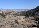
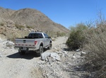
Off-road or Mountain Bike Pinkham Canyon-Thermal Canyon Roads, Joshua Tree National Park, California
Pinkham Canyon-Thermal Canyon Roads is a challenging 20-mile (32.4-km) road begins just south of Cottonwood Visitor Center, travels along Smoke Tree Wash, then cuts down Pinkham Canyon, exiting onto a service road that connects to I-10. Or you can pass Pinkham Canyon and continue on to Thermal Canyon Road. Sections of these roads run through soft sand and rocky flood ...


Price: $149.00