Give us feedback!


 See all

Our philosophy is simple. We want to encourage you to dream. BIG! Then we help you plan your trip, get the most out of it while you're traveling and help you share your experience with friends.
Join Now It's FREE
Dream Packages
Duration: 3 hours 30 minutes
Price: $99.36
Price: $99.36
Duration: 9 hours
Price: $109.14
Price: $109.14
Duration: 8 hours
Price: $83.37
Price: $83.37
Duration: 4 hours
Price: $120.43
Price: $120.43
Dreams Still To Do
Checked-Off Dreams
Dreams Still To Do
Checked-Off Dreams
Advertisement
Explore Adventure Sports
-
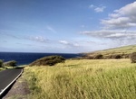
Drive Piilani Highway (Backside) to Hana, Maui, Hawaii
Take road less traveled and steer away from traffic and crowded stopsby taking the back road to Hana - as the locals do. The route starts in Kula and follow the road southwest on Piilani Highway (Hwy 31) toward Kaupo, which leads you east around the backside of Haleakala. Most of the road is desolate but along the way there is a roadside hamburger stand, a couple... -
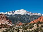
Visit Pikes Peak, Colorado
Pikes Peak (originally Pike's Peak) is a mountain in the Front Range of the Rocky Mountains within Pike National Forest, 10 miles (16 km) west of Colorado Springs, Colorado, in El Paso County in the United States of America. Originally called "El Capitán" by Spanish settlers, the mountain was renamed Pike's Peak after Zebulon Pike, Jr., an explorer who led an e... -
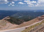
Drive Pikes Peak Highway, Colorado
The Pikes Peak Highway is a 19-mile (31 km) toll road that runs from Cascade, Colorado to the summit of Pikes Peak in El Paso County, Colorado, at an altitude of 14,115 feet (4,302 m). It is at least partially open year-round, "weather permitting",i.e.open up to the altitude where snow removal becomes excessively difficult. The highway has been home to an annual autom... -
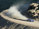
Attend Pikes Peak International Hill Climb, Colorado
The Pikes Peak International Hill Climb (PPIHC), also known as The Race to the Clouds, is an annual automobile and motorcycle hillclimb to the summit of Pikes Peak in Colorado. The track measures 12.42 miles (19.99 km) over 156 turns, climbing 4,720 ft (1,440 m) from the start at Mile 7 on Pikes Peak Highway, to the finish at 14,110 ft (4,300 m), on grades averaging 7... -
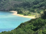
Hike to Pila'a Beach, Kauai
Pilaa Beach is a remote beach on the north shore of Kauai to relax without the crowds. It has gained fame as the beach fronting Mark Zuckerberg's property. The property behind Pilaa is privately owned and there is no direct right-of-way to the beach. The trail from the base of the hill to the west. It leads over the rocky shoreline to the west section of the beach. ... -
Take a Pilates Class
Pilates is a physical fitness system developed in the early 20th century by Joseph Pilates, and popular in many countries, including Germany, the US and the UK. As of 2005, there were 11 million people practicing the discipline regularly and 14,000 instructors in the United States alone. Pilates called his method "Contrology" (from "control" and Greek -λ&omicro... -
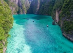
Visit Pileh (Pi Leh) Lagoon, Ko Phi Phi Lee Island, Phi Phi Islands, Thailand
Picturesque swimming inlet known for its clear waters & popular with snorkelers. -
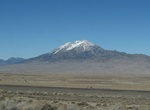
Explore Pilot Peak, Nevada
Pilot Peak (Shoshoni: Waahkai) is the highest mountain in the Pilot Range in extreme eastern Elko County, Nevada, United States. It is the most topographically prominent peak in Elko County and the fourth-most prominent peak in Nevada. The peak is on public land administered by the Bureau of Land Management and thus has no access restrictions. Pilot Peak was named in ... -
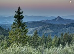
Summit Pilot Rock, Cascade-Siskiyou National Monument, Oregon
Pilot Rock is a prominent volcanic plug located in the western Cascade Range near the east end of the Siskiyou Mountains, just east of the Siskiyou Summit near Ashland, Oregon. Rising thousands of feet above the Shasta and Rogue valleys, it is a landmark distinguishable from over 40 miles (64 km) away. At 25.6 million years old, it is one of the oldest formations of t... -
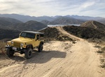
Off-road Pilot Rock OHV Trail, California
Pilot Rock OHV Trail is a 23.2 mile 4WD trail located above Silverwood Lake State Recreation Area, California. The main trail is easy for an high clearance 2WD, however many of the side trails require 4WD. This trail ends up close to Lake Arrowhead. -
Hike Pima Canyon Trails (Phoenix), Arizona
The Pima Canyon trails in the South Mountain Park offer many options. The Canyon area hikes of the park range from easy to moderate. For a challenge, hike up into South Mountain preserve. -
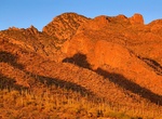
Hike Pima Canyon Trail (Tucson), Arizona
Pima Canyon is a major canyon located in the Santa Catalina Mountains, north of Catalina Foothills and Tucson, Arizona, USA. Pusch Ridge forms the northwestern cliffs of Pima Canyon, dramatically rising from Pima Creek on the canyon floor. Pima Canyon varies greatly in elevation, from 2,900 feet (880 m) above sea level at Pima Creek to 6,350 feet (1,940 m) at Pima Sad... -
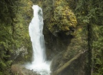
Hike to Pinard Falls, Oregon
Pinard Falls, named for Pinard Butte due east of the falls, is an impressive waterfall that forms when the East Fork of Layng Creek drops over 105-foot tall basalt cliffs. A dense, lush forest surrounds the area and shades the waterfall most of the day; however, during summer afternoons, sunlight cuts through the mist to reach the base of the waterfall. From the trai... -
Fly Fish Piñas Bay, Panama
World class Fly Fishing in an area so remote it is only reachable by boat or plane is what Pinas Bay, Panama offers enthusiasts hoping to explore their passion for catching large pelagics using their chosen equipment. Billfish (including world class Marlin and Sailfish) are the primary prey and the thrill associated with landing one of these monsters with Fly gear can... -
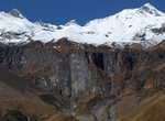
Hike Pindari Glacier, Kumaon Himalayas, India
The Pindari Glacier is a glacier found in the upper reaches of the Kumaon Himalayas, to the southeast of Nanda Devi, Nanda Kot. The glacier flows to the south for a short distance of about 3 km (1.9 mi),0.25 km in breadth and gives rise to the Pindari River which meets the Alakananda at Karnaprayag in the Garhwal district. The trail to reach the glacier crosses the vi...


Price: $469.00