Give us feedback!


 See all

Our philosophy is simple. We want to encourage you to dream. BIG! Then we help you plan your trip, get the most out of it while you're traveling and help you share your experience with friends.
Join Now It's FREE
Dream Packages
Duration: 2 days
Price: $469.00
Price: $469.00
Duration: 5 hours
Price: $106.33
Price: $106.33
Duration: 8 hours
Price: $83.37
Price: $83.37
Duration: 7 hours
Price: $179.00
Price: $179.00
Dreams Still To Do
Checked-Off Dreams
Dreams Still To Do
Checked-Off Dreams
Advertisement
Explore Adventure Sports
-
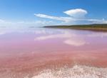
See Pink Lake (Western Australia), Australia
Pink Lake is a salt lake in the Goldfields-Esperance region of Western Australia. During certain time sof the yar the lake turned pink due the algae that live in the lake which gives it unusual complexion. The lake is not always pink in colour but the distinctive colour of the water when the lake is pink is a result of the green alga Dunaliella salina, halobacterium H... -
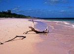
See Pink Sand Beaches on Harbour Island, Bahamas
Harbour Island is an island and administrative district in the Bahamas and is located off the northeast coast of Eleuthera Island. Harbour Island is famous for its pink sand beaches, which are found all along the east side of the island. The island is accessible by airplane through North Eleuthera Airport, followed by a short water taxi ride from neighbouring North El... -
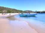
Visit Pink Tangsi Beach, Lombok, Indonesia
Pink Beach (Tangsi Beach) is a remote but stunning beach on Lombok Island in Indonesia. The sand has pink color, making it distinguish than any other beaches. This color is a mixture of white sand and tiny fragments of bright red coral skeletons of organ pipe corals. Tangsi Beach or better known as the Pink Beach is located in the small village Sekaroh, Jerowaru East ... -
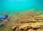
Snorkel Pinnacle Rock, Bartolomé, Galápagos
Snorkel around Pinnacle Rock with the penguins, turtles, white-tipped reef sharks, and other tropical fish. The bay is also an excellent place to go swimming. The twin bays are separated by a narrow isthmus. Galápagos penguins are frequently seen, and a small cave behind Pinnacle Rock houses a breeding colony. Seasonally, Bartolomé is the mating and nes... -
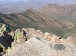
Explore Pinnacles National Park, California
Pinnacles National Park is a protected mountainous area located east of central California's Salinas Valley, about 5 miles (8.0 km) east of Soledad and about 80 miles (130 km) southeast of San Francisco. The park's namesakes are the eroded leftovers of half of an extinct volcano. The national park is divided by the rock formations into East and West Divisions, connect... -
Visit Pinnacles Overlook, Crater Lake National Park, Oregon
On the Crater Lake's southeast slopes, the canyons of Wheeler and Sand Creeks became submerged in a searing pyroclastic flow during the massive blast 7,700 years ago. Gases from the superheated rock below were released to the surface via narrow vents, welding the pyroclastic deposits in their immediate vicinity. They may be viewed from overlooks at the end of the acc... -
Hike Pinnacles Trail to Emory Peak, Big Bend National Park, Texas
Ascend the forested Pinnacles trail for 3.5 miles to the Emory Peak trail junction (on your right). Then take the 1-mile spur trail to the peak which has nice vistas along the way. The last quarter mile or so climbs steeply, and the last 25 feet require a scramble up an exposed rock face, but the 360° view from Emory Peak, the highest point in the park, is superb.... -
Trek Pin Parvati Pass, Himachal Pradesh, India
The Pin Parvati Pass is a mountain pass in Himachal Pradesh, India. It was first crossed in August 1884 by Sir Louis Dane in search of an alternate route to the Spiti valley. This pass connects the fertile and lush Parvati valley on the Kullu side with the Pin valley on the Spiti side. It is a popular trekking route today though still rarely visited. This trans-Himala... -
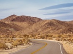
Drive Pinto Basin Road & Cottonwood Springs Road, Joshua Tree National Park, California
Pinto Basin Road and Cottonwood Springs Road act as a continuous roadway which connects the Mojave Desert to the Sonoran Desert. Pinto Basin Road leaves Park Boulevard 4.6 miles from the parks North Entrance and heads south 29.7 mile to the Cottonwood Visitor Center at the foot the Cottonwood Mountains. It's an additional 6.9 miles to the South Entrance at the I-10 fr... -
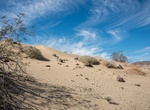
Hike Pinto Basin Sand Dunes Trail, Joshua Tree National Park, California
The Pinto "Sand Dunes" are piles of sand built up against a low-lying ridge of rocky hills. There is no maintained trail leading to the dunes, however the ridge is visible from Turkey Flats and a fairly direct N-NE path can be taken to them. The hike starts at the Turkey Flats Backcountry Board. According to local folklore, an enthusiastic farmer in the 1920s thought... -
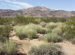
Hike Pinto Mountains thru Turkey Flats, Joshua Tree National Park, California
The Pinto Mountains are found in southern California, USA, at the north-central part of Joshua Tree National Park. The range reaches an elevation of 1,390 meters (4,560 ft) southeast of the city of Twentynine Palms. The range is made up of dark gneiss, and the creosote bush is the dominant plant in the area. The cross-country hiking route starts at Turkey Flats parkin... -
Hike to Pinto Wye Wash, Joshua Tree National Park, California
Off to the west of Pinto Wye is a wash will lead through a pretty neat little canyon, past several mines. -
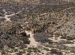
Off-road Pinyon Mountain Road (The Squeeze & Heart Attack Hill), Anza-Borrego Desert State Park, California
Pinyon Mountain Road begins at Highway S-2 (Stagecoach Trails RV Resort) just south of and connect with Hapaha Flat Rd and Fish Creek Wash, it has 3 challenging areas,The Squeeze, Pinyon Drop-off better known as Heart Attack Hill and a short treacherous canyon between them. The trail is one-way once arriving at The Squeeze. -
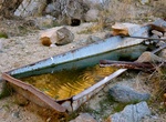
Hike to Pinyon Well, Joshua Tree National Park
Pinyon Well is located 0.7 miles up a canyon off Geology Tour Road in Joshua Tree National Park. Pinyon Well was a small, active community in the late 1890s and up through the 1910s. It was there because of a reliable source of water from three wells in the area, and the steam-powered, two-stamp mill that crushed ore for the nearby mines. A round-trip hike from the tr... -
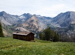
Hike or Mountain Bike Pioneer Cabin Trail, Idaho
One of the best Sun Valley day hikes is to Pioneer Cabin, which rises 2,400 feet in just four miles.There are great views of the Pioneer Mountains, and trail end up at the Pioneer Cabin, which goes all the way back to the ’30s. Hikers can spend the night in the shelter.


Price: $208.72