Give us feedback!

Our philosophy is simple. We want to encourage you to dream. BIG! Then we help you plan your trip, get the most out of it while you're traveling and help you share your experience with friends.
Join Now It's FREE
Related Categories
Dreams Still To Do
Checked-Off Dreams
Dreams Still To Do
Checked-Off Dreams
Advertisement
Explore UNESCO Sites
-
Visit Milecastle 36 King's Hill (Hadrian's Wall), England (UNESCO site)
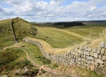
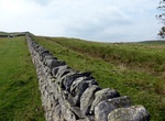
Milecastle 36 (King's Hill) was one of the milecastles on Hadrian's Wall (grid reference NY79726931). There is little to see on the ground as most of the walls have been robbed and quarried away. The site of Milecastle 36 is located on King's Hill, 800 metres northeast of Housesteads Roman Fort. The milecastle was robbed of most of its remaining stone in 1831. Part of... -
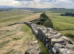
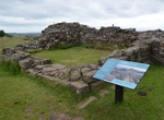
Visit Milecastle 37 (Cuddy's Crags) Hadrian's Wall, England
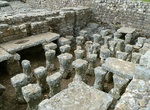
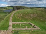
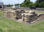
Milecastle 37 is one of the milecastles on Hadrian's Wall. It is immediately west of the Housesteads Roman Fort (grid reference NY78506869). The remains have been partly reconstructed and consolidated; it is now in the care of English Heritage. The wall has a maximum height of 2.2 metres internally. The milecastle has a short axis, with a Type I gateway. The milecastl... -
Visit Milecastle 39 (Castle Nick) & Peel Gap Tower (Hadrian's Wall), England (UNESCO site)
Milecastle 39 (Castle Nick) is a milecastle on Hadrian's Wall (grid reference NY76066773). Milecastle 39 is located northeast of Once Brewed. The excavated stonework has been consolidated, and the walls are up to 1.75 metres high. It measures 19 metres by 15.5 metres. The site was cleared in 1854, and was excavated in 1908-11. It was re-excavated between 1982 and 1987... -
Visit Milecastle 40 Winshields (Hadrian's Wall), England (UNESCO site)
Milecastle 40 (Winshields) was a milecastle on Hadrian's Wall (grid reference NY74566758). Milecastle 40 is located northwest of Twice Brewed, just below the top of Winshields. The milecastle can be seen as turf-covered rubble banks up to 1.0 metre high. The milecastle was excavated in 1908. The remains were greatly disturbed but the south wall was still ten courses h... -
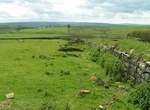
Visit Milecastle 41 Melkridge (Hadrian's Wall), England (UNESCO site)
Milecastle 41 (Melkridge) was a milecastle on Hadrian's Wall (grid reference NY73026705). Milecastle 41 is located to the east of Caw Gap. The milecastle can be seen as turf-covered banks outlined by robber trenches. A cottage, long removed, occupied the site of, and was built from, the materials of milecastle 41. The milecastle was examined in 1946. It was found to h... -
Visit Milecastle 43 Great Chesters (Hadrian's Wall), England (UNESCO site)
Milecastle 43 (Great Chesters) was a milecastle on Hadrian's Wall (grid reference NY70356684). It was obliterated when the fort at Great Chesters (Aesica) was built. Milecastle 43 was situated at Great Chesters, and was destroyed when the Aesica fort was built. The foundations were discovered during an excavation in 1939, and were found beneath the fort wall and rampa... -
Visit Milecastle 44 Allolee (Hadrian's Wall), England (UNESCO site)
Milecastle 44 (Allolee) was a milecastle on Hadrian's Wall (grid reference NY68886694). Milecastle 44 is located about 1.5 kilometres (0.93 mi) west of the Great Chesters fort (Aesica). The milecastle survives as a small number of visible facing stones, and a turf-covered bank. The bank measures 3.5 metres (11 ft) wide and 0.9 metres (3.0 ft) high. It is a long-axis t... -
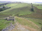
Visit Milecastle 45 Walltown (Hadrian's Wall), Walltown Crags, England (UNESCO site)
Milecastle 45 (Walltown) was a milecastle on Hadrian's Wall (grid reference NY67716657). Milecastle 45 is located on the top of Walltown Crags. The walls have been comprehensively robbed, and little remains but the robber trenches and turf-covered spoil mounds. The site is clearly visible as earthworks on aerial photographs. Each milecastle on Hadrian's Wall had two a... -
Visit Milecastle 7 Benwell Bank (Hadrian's Wall), England (UNESCO site)
Milecastle 7 (Benwell Bank or Benwell Hill) was a milecastle of the Roman Hadrian's Wall. The milecastle itself has not been discovered by archaeologists and its presumed location lies beneath a modern housing development. Roman finds have been made in the area and the associated structure of Turret 7B is a significant surviving structure of the wall. Milecastle 7 has... -
Visit Militello in Val di Catania, Italy (UNESCO site)
Militello in Val di Catania is a town in the province of Catania in the Italian region Sicily, located about 160 km southeast of Palermo and about 35 km southwest of Catania, on the last slopes of the Iblean Mountains. It has a railways station on the line Catania-Gela. Together with other cities of the Val di Noto, Militello has been inscribed in the UNESCO World Her... -
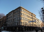
See Milk Processing Company (Pieno centras), Kaunas, Lithuania
The Milk Processing Company (Pieno centras) is a multifunctional building designed by architects Vytautas Landsbergis-Žemkalnis and Karolis Reisonas.It is one of the most prominent examples of modernist architecture in Kaunas. The building was built for the Central Union of Lithuanian Milk Processing Companies "Pienocentras", 1946-2014. The project of the palace in 1... -
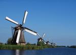
See Mill Network at Kinderdijk-Elshout, Netherlands (UNESCO site)
Kinderdijk is a village in the Netherlands, belonging to the municipality of Nieuw-Lekkerland, in the province South Holland, about 15 km east of Rotterdam. Kinderdijk is situated in a polder at the confluence of the Lek and Noord rivers. To drain the polder, a system of 19 windmills was built around 1740. This group of mills is the largest concentration of old windmi... -
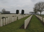
Visit Mill Road Cemetery, Thiepval, France
Mill Road Cemetery is a Commonwealth War Graves Commission burial ground for the dead of World War I situated near the French town of Thiepval. The cemetery was established as a battlefield cemetery for troops killed in the Battle of the Somme. Battlefield clearances of the surrounding area in 1919 significantly increased the size of the cemetery. The cemetery was ext... -
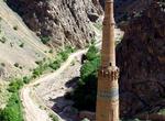
See Minaret of Jam, Afghanistan (UNESCO site)
The Minaret of Jam is a UNESCO World Heritage Site in western Afghanistan. It is located in the Shahrak District, Ghor Province, by the Hari River. The 65-metre high minaret, surrounded by mountains that reach up to 2400m, was built in the 1190s, entirely of baked-bricks. It is famous for its intricate brick, stucco and glazed tile decoration, which consists of altern... -
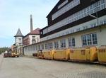
See Mines of Rammelsberg, Germany (UNESCO site)
The Rammelsberg is a mountain, 635 m high, on the northern edge of the Harz, south of the town of Goslar in the north German state of Lower Saxony. The mountain is the location of an important mine, the only mine which had been working continuously for over 1,000 years when it finally closed in 1988. Since 1992, the visitors' mine of Rammelsberg has become a UNESCO Wo...