Give us feedback!

Our philosophy is simple. We want to encourage you to dream. BIG! Then we help you plan your trip, get the most out of it while you're traveling and help you share your experience with friends.
Join Now It's FREE
Related Categories
Dreams Still To Do
Checked-Off Dreams
Dreams Still To Do
Checked-Off Dreams
Advertisement
Explore Viewpoints
-
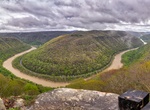
Visit Grandview Main Overlook, Beaver, West Virginia
Perched on the edge of the gorge 1400 feet above the river, Grandview provides some of the best views of the gorge -
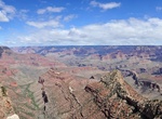
Visit Grandview Point, Grand Canyon National Park, Arizona
Grandview Point (Elevation: 7399 feet / 2256 meters) is a popular viewpoint offers panoramic views of Grand Canyon from east to west, including several bends of the Colorado River to the east.The historic Grandview Trail begins here. This trail is VERY steep! In the summer much of the trail is in full sun. In the winter ice and snow can make hiking treacherous. Always... -
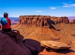
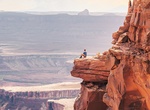
Hike to Grand View Point Overlook, Canyonlands National Park, Utah
Grand View Point Overlook in Canyonlands National Park is an easy 2.0 miles (3.2 km) walk out from parking area and a great view. -
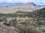
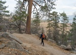
Hike to Granite Mountain Hotshots Memorial Observation Deck, Arizona
Hike the Hotshots Trail from the parking lot trailhead up to the overlook where you'll see sweeping views in every direction, and perhaps leave a memento on our rememberance wall. -
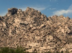
Visit Granite Mountains Viewpoint, California
Pull off on Kelbaker Rd to see Granite Mountains Nature Reserve boulders. -
Hike Grays Peak Trail, Big Bear Lake, California
This trailhead is located on the west side of HWY 38, North Shore Drive. It is 0.6 of a mile west of Fawnskin, across from the Grout Bay Picnic Area. (This trailhead is in the center of a bald eagle wintering habitat area and is closed to all public when nesting occurs, usually from winter to spring, though it can extend into summer.) The trail climbs westerly for 0.... -
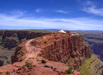
Visit Green River Overlook, Canyonlands National Park, Utah
The Green River Overlook in Canyonlands National Park is located next to Willow Flat Campground. -
Visit Guano Point, Arizona
Guano Point is located on the west rim of the Grand Canyon in Arizona on Hualapai tribe land. Go to the tip of the point and experience a nearly 360 degree canyon view. -
Visit Gudauri Viewpoint, Kazbegi National Park, Georgia
Mountaintop lookout with sweeping views & the painted, concrete Russia-Georgia Friendship Monument. -
Hike to Gümüşlük Flag, Gümüşlük, Bodrum, Muğla Province, Turkey
The Gümüşlük flag hike is a short, uphill walk to a prominent flag on a hilltop with panoramic views of the coast, the village, and the ancient ruins of Myndos. The viewpoint is a popular spot for visitors to see the bay and capture photos of the scenic landscape. -
Visit Haad Rin Rock View Point, Ko Pha Ngan, Thailand
It's a steep climb to this viewpoint but offers great views of Haad Rin and Koh Samui. -
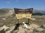
Off-road to Hagerman Pass, Colorado
Hagerman Pass, elevation 11,925 ft (3,635 m), is a high mountain pass that crosses the continental divide in the Rocky Mountains of central Colorado in the United States. The pass traverses the Sawatch Range west of Leadville, connecting the headwaters of the Arkansas River on the east with the upper valley of the Fryingpan River above Basalt, in the basin of the Colo... -
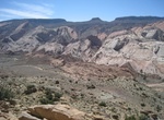
Visit Halls Creek Overlook, Capitol Reef National Park, Utah
Halls Creek Overlook is located on a spur road three miles (4.8 km) west of the Notom-Bullfrog Road. The spur road is rough and sometimes requires high clearance four wheel drive. The Notom-Bullfrog Road is hard-packed dirt, usually passable to passenger cars. Total distance from Hwy 24 is 57.6 miles (92.7 km). -
Visit Hamon Observation Tower, de Young Museum, San Francisco, California
The Hamon Observation Tower stands 144 feet tall. It's part of the de Young Museum. -
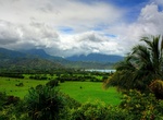
Visit Hanalei Bay Lookout, Kuhio Hwy, Princeville, Hawaii
Viewpoint just outside of Princeville along Kuhio Hwy that overlooks Hanalei Bay.