Give us feedback!

Our philosophy is simple. We want to encourage you to dream. BIG! Then we help you plan your trip, get the most out of it while you're traveling and help you share your experience with friends.
Join Now It's FREE
Related Categories
Dreams Still To Do
Checked-Off Dreams
Dreams Still To Do
Checked-Off Dreams
Advertisement
Explore Viewpoints
-
Hike to Pico de Chinobre, Tenerife Island, Canary Islands
Pico de Chinobre is a viewpoint with a short hike from TF-123. -
Visit Pier C Park, Hoboken, New Jersey
This park with scenic views of NYC features a fishing pier, playground, water play area & promenade. -
View Lisbon from Pilar 7 25 April Bridge, Lisbon, Portugal
25 April Bridge ( port Ponte 25 de Abril ) - a suspension bridge connecting Lisbon , the capital of Portugal with the municipality of Almada on the left (southern) bank of the Tagus river . It was opened for use on August 6, 1966. The railway level was added in 1999. Due to the similarity of form and color, it is often compared to the Golden Gate Bridge in San Francis... -
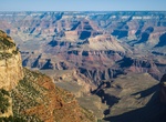
Visit Pima Point, Grand Canyon National Park, Arizona
Pima Point is one of the best places on the rim to see (and sometimes hear) the Colorado River. Pima Point along Hermit Road on the South Rim of Grand Canyon National Park. Hermits Rest is 1.1 miles (1.8 km) west from here on the paved Greenway Trail. Monument Creek Vista is 1.7 miles (2.7 km) east from here on the paved Greenway Trail. -
Visit Pink Cliffs Viewpoint, Bryce Canyon National Park, Utah
Pink Cliffs Viewpoint is along the Bryce Canyon Rim Road. The Pink Cliffs are a series of highly dissected cliffs, approximately 35 mi (56 km) long, along the southeast edge of the Paunsaugunt Plateau in southwestern Utah in the United States. The cliffs form unique rock formations and are largely protected as part of Bryce Canyon National Park. -
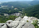
Visit Pinnacle Overlook, Kentucky
Leaving the visitor center, park visitors can drive the winding, four-mile-long Skyland Road up the mountain to the Pinnacle Overlook (elevation 2,440 feet) for a spectacular view into Kentucky, Virginia, and Tennessee. Skyland Road is periodically closed during the winter due to inclement weather. The road is closed to vehicles 20 feet or longer in length. When par... -
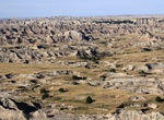
Visit Pinnacles Overlook, Badlands National Park, South Dakota
Pinnacles Overlook is a popular stop along Badlands Loop Road (Hwy 240). -
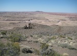
Visit Pintado Point, Petrified Forest National Park, Arizona
Pintado Point overlooks the red part of the Painted Desert. The point is one of eight Painted Desert Overlooks in Petrified Forest National Park. -
Visit Pipe Creek Vista, Grand Canyon National Park, Arizona
The Pipe Creek Vista pullout can be accessed by private vehicle or by using the free Kaibab Rim Route (Orange) Shuttle Bus, departing from the Grand Canyon Visitor Center.The Canyon Rim Trail may be accessed here, with a 1.3 mile / 2.1 km walk on a paved trail west to Mather Point, or a 0.8 mile / 1.3 km walk east to the South Kaibab Trailhead. -
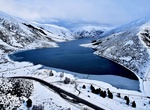
Visit Pippa’s Lookout at Lake Lyndon, Castle Hill, New Zealand
Lake Lyndon is a small lake in the Canterbury region of New Zealand's South Island. It is located near Porters Pass on State Highway 73 after Springfield heading into the Southern Alps. The lake regularly freezes in winter due to its elevation and location on the outer border of the Southern Alps. It is roughly an hour from Christchurch and is a popular site for rainb... -
Snap a Picture at Place du Trocadéro, Paris, France
Place du Trocadéro, an elevated, open space with a stellar view of Paris’s most iconic landmark. -
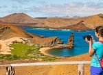
Hike to Playa Dorada Overlook, Bartolomé Island, Galápagos
A planked 114-metre hiking trail leads up the side of Bartolomé's volcanic cone. The summit provides views across the water to other islands in the archipelago. -
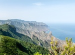
Visit Pointe de Pen-Hir, Camaret-sur-Mer, France
The pointe de Pen-Hir (Breton - Beg Penn Hir) is a promontory of the Crozon peninsula in Brittany, to the south-west of Camaret-sur-Mer. On a clear day there are views to the Pointe du Raz and the islands of Sein and Ouessant and to Pointe Saint-Mathieu. The cliffs can be as tall as 70 metres (230 ft) high. It is the site of the Monument to the Bretons of Free France,... -
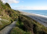
Hike Point Elizabeth Walkway, West Coast, New Zealand
A stunning, well surfaced, coastal walkway. Enjoy walking through varied and interesting forest to a panoramic, cliff top viewing platform. Point Elizabeth track is a perfect walk for families and children. -
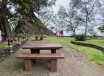
Visit Pointe Tapahi, Tahiti
Point Tapahi is a view point just near the village of Orofara. It's the true start of east coast and the wind that is dramatically different from the North and West Coasts.