Give us feedback!

Our philosophy is simple. We want to encourage you to dream. BIG! Then we help you plan your trip, get the most out of it while you're traveling and help you share your experience with friends.
Join Now It's FREE
Related Categories
Dreams Still To Do
Checked-Off Dreams
Dreams Still To Do
Checked-Off Dreams
Advertisement
Explore Bureau of Land Management (BLM)
-
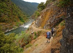
Hike The Rogue River National Recreation Trail, Oregon
TheRogue River National Recreation Trail stretching 40 miles between Grave Creek and Big Bend, offers some of southwestern Oregon's most amazing landscapes and rewarding hiking experiences. The trail traverses the wild section of the Rogue National Wild and Scenic River along its entire length. Along the river you may see deer and otters, or even black bears looking ... -
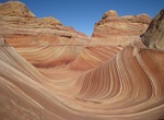
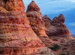
Hike to The Wave (North Coyote Buttes), Utah & Arizona
The Wave is located on the Colorado Plateau, near the Utah and Arizona border. The Wave is a multi-colored chute that has been cut into a sandstone mountain. Swirled bands of color run through the sandstone, which has eroded into interesting shapes. The colors and shapes change with the light as the day progresses. Red, pink, yellow and green rock has been blended tog... -
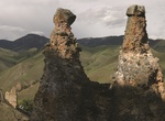
Explore Tower Creek Pyramids, Idaho
Located on the banks of Tower Creek about 12 miles from Salmon, Idaho, this site was homesteaded some years after the Lewis and Clark Expedition visited in 1805 and was donated back to the BLM in 2002. A picnic/day-use area in the homestead’s old apple orchard lies within view of the geologic formations that William Clark phonetically noted in his journal as &ld... -
Drive or Mountain Bike Transcontinental Railroad Backcountry Byway, Utah
The Transcontinental Railroad Backcountry Byway follows almost 90 miles of the Central Pacific Railroad Grade following an old railroad grade and travels through remote settings. Today, cattle graze where thousands of Chinese immigrants labored in 1869 to open the West to industry and commerce. The Transcontinental Railroad Back Country Byway is interpreted at over 20... -
Explore Trapper Creek WSA, Wyoming
The Trapper Creek WSA encompasses 7,200 acres of BLM-administered public land with no private or state inholdings. Trapper Creek is one of the most spectacular canyons on the west slope of the Bighorns. It is characterized by the dramatic vertical relief of the cliffs, spires, and massive rock outcrops of the canyon walls, as well as the presence of a clear cascading ... -
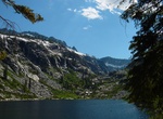
Explore Trinity Alps Wilderness, California
The Trinity Alps Wilderness is a 525,627-acre (212,714 ha) designated wilderness located in northern California, roughly between Eureka and Redding. It is jointly administered by Shasta-Trinity, Klamath, and Six Rivers National Forests. About 4,623 acres (1,871 ha) are administered by the Bureau of Land Management. The wilderness is located in the Salmon and Scott Mou... -
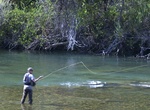
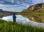
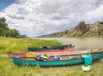
Explore Trinity Wild and Scenic River, California
Popular with fisherman and pleasure boaters alike, the 43 miles of the Wild and Scenic Trinity River from Lewiston to Pigeon Point is a class I and II segment that flows out of the Trinity and Lewiston Lakes. This clear, cold section of the river is world famous for its fly fishing. Paddlers enjoy the narrow valley with Ponderosa Pine, Douglas fir, Oaks, and Madrone t... -
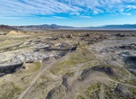
Off-road to Trona Pinnacles, California
The Trona Pinnacles are a very otherworldly place; so-much-so that movies including Star Trek and Planet of the Apes were filmed here to represent alien planets. It's hard to believe this stark area was covered by a large lake during the much wetter pleistocene period more than 10,000 years ago. Over 500 spires formed underwater when the area was covered by a large la... -
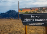
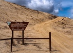
Visit Tumco Historic Mining Town, California
Tumco is an abandoned gold mining town and is also one of the earliest gold mining areas in California. It has a history spanning some 300 years, with several periods of boom and bust. Originally named Hedges, the town was completely abandoned in 1905, victim to speculative over-expansion and increasing debt. Renamed Tumco in 1910 -- after The United Mines Company -- ... -
Explore Tumey Hills, California
The Tumey Hills are a low mountain range in the interior California Coast Ranges, in western Fresno County, California. The Tumey Hills area is part of the U.S. Bureau of Land Management (BLM), which is a division of the United States Department of the Interior. This BLM land is under Fire Season Vehicle Restrictions from mid-April to mid-October. No motorized access ... -
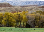
Explore Upper Missouri River Breaks National Monument, Montana
The Missouri Breaks is located in central Montana, U.S. and is managed by the U.S. Bureau of Land Management (BLM) under the full title of Upper Missouri River Breaks National Monument. Called "The Breaks" by locals, it is a series of badland areas characterized by rock outcroppings, steep bluffs and grassy plains. Created on January 17, 2001, it encompasses 377,000 a... -
Explore Upper Missouri Wild and Scenic River, Montana
The Upper Missouri National Wild and Scenic River Management Plan highlights; the uniqueness, special values and wild and scenic qualities that were instrumental in the designation on October 12, 1976. Of special note is the fact that the Upper Missouri contains segments of all three river classifications contained in the Wild and Scenic Rivers Act of 1968. These clas... -
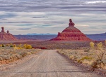
Drive Valley of the Gods Road, Utah
The Valley of the Gods is a scenic sandstone valley near Mexican Hat in San Juan County, southeastern Utah. The beautiful Cedar Mesa sandstone monoliths, pinnacles and other geological features of this enchanting area are known as a Miniature Monument Valley. These sandstone sentinels were eroded by wind and water over millions of years. It is part of Bears Ears Natio... -
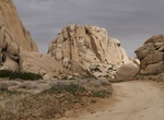
Off-road & Hike Valley of the Moon (Smuggler's Den & Elliot Mine), Jacumba Wilderness, California
Valley of the Moon (Smuggler's Den) is a four-wheel-drive trail with some historical treasureslocated in Jacumba Wilderness just north of the U.S./Mexico border. -
Explore Vermilion Cliffs National Monument, Arizona
Vermilion Cliffs National Monument is located in Arizona, immediately south of the Utah state line. This National Monument, 294,000 acres (1,190 km2) in area, protects the Paria Plateau, Vermilion Cliffs, Coyote Buttes, and Paria Canyon. Elevations in the Monument range from 3,100 feet to 6,500 feet above sea level (944 to 1,981 meters). Established on November 9, 200...