Give us feedback!

Our philosophy is simple. We want to encourage you to dream. BIG! Then we help you plan your trip, get the most out of it while you're traveling and help you share your experience with friends.
Join Now It's FREE
Related Categories
Dreams Still To Do
Checked-Off Dreams
Dreams Still To Do
Checked-Off Dreams
Advertisement
Explore Bureau of Land Management (BLM)
-
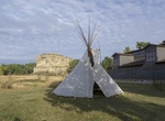
Visit Pompeys Pillar National Monument, Montana
Pompeys Pillar National Monument is a rock formation located in south central Montana, United States. Designated a National Monument on January 17, 2001, and managed by the U.S. Bureau of Land Management, it consists of only 51 acres (21 ha), making it one of the smallest National Monuments in the U.S. It was previously designated a National Historic Landmark on July ... -
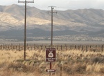
Drive Pony Express Trail Back Country Byway, Utah
Relive a dramatic part of the West's history as you travel the same trail that Pony Express riders covered over 100 years ago. You can stop at stations and modern interpretive sites along the Backcountry Byway where exhausted riders once rested before continuing on to complete their 1,800-mile run. You can extend your visit to the past with a night's stay at the campg... -
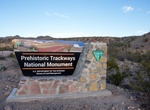
Visit Prehistoric Trackways National Monument, New Mexico
Prehistoric Trackways National Monument is the 100th national monument in The United States of America. The monument is located in the Robledo Mountains, near Las Cruces in the southern region of the U.S. state of New Mexico. The monument's fossilized features are on 5,280 acres of Bureau of Land Management administered land in Doña Ana County. The Prehistoric ... -
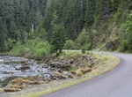
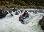
Drive Quartzville Back Country Byway, Oregon
The Quartzville Back Country Byway parallels the winding Quartzville Creek Wild and Scenic River, offering views of old-growth forests and wildlife, and provides easy access to developed and undeveloped picnic and camping sites. The corridor offers a variety of recreational opportunities, such as fishing, camping and boating for skilled whitewater paddlers. Quartzvil... -
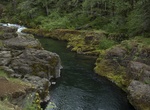
Explore Quartzville Creek Wild and Scenic River, Oregon
Quartzville Creek begins in the Cascade Mountain Range of Oregon. The 12-mile section that was designated in 1988 flows into Green Peter Reservoir near the town of Sweethome. Classified as a recreational section of river, Quartzville Creek is named for the gemstone that has been mined in the area and a ghost town that was once the center of two brief gold mining effor... -
Hike Rainie Falls Trail, Oregon
Rainie Falls Trail is a 3.6 mile out and back trail located near Grants Pass, Oregon that features a waterfall. During spawning season, salmon and steelhead can be seen jumping at the falls. -
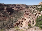
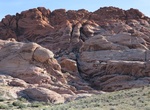
Hike Rattlesnake Canyon (Colorado)
Rattlesnake Canyon is a scenic area within the Black Ridge Canyons Wilderness which in turn forms the core of the Bureau of Land Management administered McInnis Canyons National Conservation Area in west central Colorado. The canyon contains nine natural arches, the second highest concentration of such arches in the United States, after the much better known Arches Na... -
Explore Red Cliffs National Conservation Area, Utah
The Red Cliffs National Conservation Area is a 44,724-acre (180.99 km2) National Conservation Area located in southwest Utah, north of St. George at the northeastern-most edge of the Mojave Desert. It is managed by the Bureau of Land Management as part of the National Landscape Conservation System, and was created as part of the Omnibus Public Land Management Act of 2... -
Mountain Bike Red Fleet Downhill Flow Trail, Vernal, Utah
Red Fleet Downhill Flow Trail is located near Vernal, Utah. The trail offers a unique experience for visitors looking to hone their mountain bike speed and technical skills. Trail users can select from a green (easy), blue (intermediate), or double black (advanced) course based on their experience, and comfort levels. The trail system is located 12 miles outside of ... -
Explore Red Rock Canyon National Conservation Area, Nevada
Red Rock Canyon National Conservation Area in Nevada located about 15 miles (24 km) west of Las Vegas, and easily seen from the Las Vegas Strip. The conservation area showcases a set of large red rock formations: a set of sandstone peaks and walls called the Keystone Thrust. The walls are up to 3,000 feet (910 m) high, making them a popular hiking and rock climbing d... -
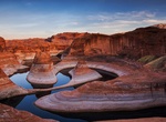
Hike to Reflection Canyon, Grand Escalante Staircase National Monument, Utah
Located in Grand Escalante Staircase National Monument, Reflection Canyon is an extension of Lake Powell. It is usually seen by boat and plane, but there is a challenging 20-mile round-trip hike through the Glen Canyon to see the view into the canyon. Going by boat sounds easy, but to get to the top for this view is extremely difficult. The hike requires a 49-mile d... -
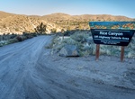
Off-road Rice Canyon OHV Area, Susanville, California
The Rice Canyon off-highway vehicle (OHV) Open area lies within the Antelope/Shaffer/Bald Mountain Special Recreation Area (SRMA). The open area is about 8 miles east of Susanville, California, and consists of 120 acres of public land managed primarily for open OHV use. All OHV use beyond the open area is limited to designated routes and trails. The OHV open area is o... -
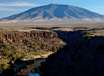
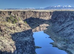
Explore Río Grande del Norte National Monument, Taos County, New Mexico
The Rio Grande del Norte National Monument is an approximately 242,455-acre area of public lands in Taos County, New Mexico, proclaimed as a national monument on March 25, 2013 by President Barack Obama under the provisions of the Antiquities Act. It consists of the Rio Grande Gorge and surrounding lands, managed by the Bureau of Land Management (BLM). The monument in... -
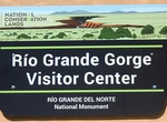
Visit Rio Grande Gorge Visitor Center, Taos, New Mexico
Rio Grande Gorge Visitor Center provides information and interpretive exhibits about the Wild and Scenic Rio Grande and surrounding countryside. In the center's bookstore, operated by the nonprofit Public Lands Interpretive Association, visitors can find books, maps, and educational gifts and toys. Commercial outfitters use the visitor center and its parking lot as a ... -
Explore Rio Grande Wild and Scenic River (New Mexico)
The Rнo Grande Wild and Scenic River, located within the Rнo Grande del Norte National Monument, includes 74 miles of the river as it passes through the 800-foot deep Rнo Grande Gorge. Flowing out of the snowcapped Rocky Mountains in Colorado, the river journeys 1,900 miles to the Gulf of Mexico. Here the river flows in a rugged and scenic part of northern New Mexico....