Give us feedback!

Our philosophy is simple. We want to encourage you to dream. BIG! Then we help you plan your trip, get the most out of it while you're traveling and help you share your experience with friends.
Join Now It's FREE
Related Categories
Dreams Still To Do
Checked-Off Dreams
Dreams Still To Do
Checked-Off Dreams
Advertisement
Explore Bureau of Land Management (BLM)
-
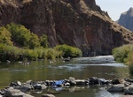
Visit Snively Hot Springs, Oregon
Snively Hot Springs is along the Owyhee River below Owyhee Dam in Eastern Oregon. -
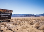
Explore Soda Mountains Wilderness, California
This scenic, horseshoe-shaped range includes the terminus of the great Mojave. Creosote, barrel cacti, cholla, and yuccas can be found along with the unique Crucifixion thorn. Two intermittent lakes, East Cronese and West Cronese, provide habitat for wintering and migrating waterfowl and shorebirds, including the endangered Yuma clapper rail. The unusual concentration... -
Explore Sonoran Desert National Monument, Arizona
The Sonoran Desert National Monument contains magnificent examples of untrammeled Sonoran Desert landscape. This National Monument is the most biologically diverse of the North American deserts, and the monument captures a significant portion of that diversity. The most striking aspect of the plant community within the monument is the extensive saguaro cactus forest. ... -
Explore South Nopah Wilderness, California
Easily rolling alluvial slopes (bajadas) from the east and west sweep gently up to the south end of the rugged folds of the Nopah Mountain Range in the South Nopah Range Wilderness. Shaded with soft colors, the Nopah Range is composed of sedimentary rocks capped at about 4,200 feet. The California Valley extends into the eastern Wilderness. Desert bighorn sheep may be... -
Off-road St. Anthony Sand Dunes, Idaho
Located far from any ocean, the BLM-managed St. Anthony Sand Dunes appears as a rolling sea of sand on the eastern edge of Idaho’s volcanic Snake River Plain. These vast dunes are the largest in Idaho. They blanket an area approximately 35 miles long and 5 wide, and range from 50 to 500 feet high. These white quartz sand dunes are a unique and popular recrea... -
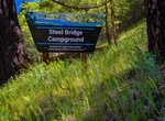
Camp at Steel Bridge Campground, Douglas City, California
The Trinity Wild and Scenic River emerges clear and cold from Lewiston Lake and flows through a deep mountain valley cloaked with conifers. The river is very popular among salmon and steelhead anglers who are often seen on crisp fall and winter mornings fly fishing from drift boats. The area has an abundance of camping places including the BLM-managed Steel Bridge, Do... -
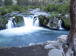
Hike to Steelhead Falls, Oregon
The long narrow canyon that surrounds the Deschutes River in the Steelhead Falls area pulls visitors away from nearby human influences and places them in a spectacular steep-sloped channel of unique character. Noise from human infrastructure is masked by the roar of the river at the falls, and hikers become entranced by the colors of the stream-side vegetation and the... -
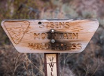
Explore Steens Mountain Wilderness, Oregon
The Steens Mountain Wilderness is a wilderness area surrounding a portion of Steens Mountain of southeastern Oregon in the United States. The reserve falls within the Steens Mountain Cooperative Management and Protection Area (CMPA). Both the reserve and the CMPA are administered by the Bureau of Land Management. The wilderness area encompasses 170,166 acres (68,864 h... -
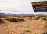
Off-road Stoddard Valley OHV Area, Barstow, California
Located in the Mojave Desert of Southern California, Stoddard Valley OHV Recreation Area offers a diverse landscape for off-highway vehicle recreation. It is characterized by steep rocky mountains, rolling hills, open valleys, and winding sandy washes. Most area visitors ride motorcycles or ATV/UTVs, or tour the area in four-wheel drive vehicles.This 53,000 acre open... -
Camp at Superbowl Campground, Bears Ears National Monument, Utah
Superbowl Campground is a good option for visitors wishing to recreate in the Indian Creek area of Bears Ears National Monument or be close to the Needles District of Canyonlands National Park. The campground is located south off the Needles Highway (accessed from Utah State Route 211), approximately 6.5 miles southeast of Canyonlands National Park and 13.5 miles nort... -
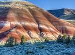
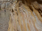
Explore Sutton Mountain Wilderness Study Area, Oregon
The painted hills of the Sutton Mountain Wilderness Study Area in central Oregon. The study area, as described by Bob Wick, BLM photographer, who visited in June of 2016 (edited for brevity, clarity): "It is one of those BLM gems that almost no-one outside the local area has heard about. The lower part of the WSA has exposures of the same clay formations that are fo... -
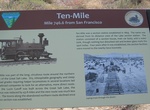
Visit Ten-Mile, Transcontinental Railroad, Utah
Ten-Mile, Utah is a ghost town located in the western part of Box Elder County, Utah. It was established by the Central Pacific Railroad (CPRR) on April 1869. Chinese railroad workers built a small community and facilities to support the track section. The town relied on the railroad through its entire history. In 1904 the site was abandoned when the Lucin Cutoff was ... -
Off-road to The Barracks Trail, Utah
The Barracks Trail is 27 miles that goes through the gorgeous landscape of Southern Utah. The Barracks is a great canyon along the East Virgin River just outside Zion National Park. -
Hike The Chute at Muddy Creek, Utah
Muddy Creek is a stream which drains portions of Emery and Wayne Counties in central Utah, in the western United States. It begins on the eastern slopes of the Wasatch Plateau at elevations above 10,500 feet (3200 m). It turns southward near the town of Emery, then southeastward where it crosses under Interstate 70. It then directly enters the western flank of the San... -
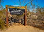
Camp at The Hot Springs LTVA, California
BLM's Long Term Visitor Areas (LTVAs), where visitors can camp for as long as seven months. The Hot Springs LTVA is known for it's historic and still active hot spring attracting both local and winter visitors. Fee season September 15-April 15 $180, $80 4-week stay, $40 2-week stay; 14 day camping free April 16-September 14. You must have a permit to camp in a designa...